Enable Location

We need your location to show you interesting places around you

Discover nearby places

Find interesting locations and hidden gems around you

Precise directions

Get accurate directions and distances to places

Your location is never shared with other users. It's only used when you tap the location button.

Itkillik River

Log in to your account

Start exploring — it's free

Trusted by 62,972 travelers worldwide

Continue with Google
Continue with Apple
or

We will send you a code to connect

By continuing, you accept our Terms and Conditions and our Privacy Policy

Check your inbox

We've sent a pincode in your inbox. Please enter the code below.

Itkillik River
Discussion Reviews 1 Photos
1.2k Popularity

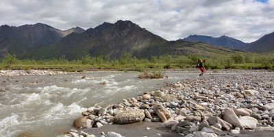
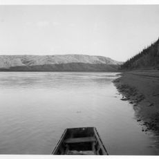
Itkillik River, Remote brook in North Slope, Alaska.

The Itkillik River is a mountain stream in Alaska's North Slope region that flows through the Endicott Mountains toward the Colville River. It cuts through remote terrain characterized by tundra, rocky slopes, and glacial features.

The name comes from the Iñupiaq word 'It-kil-lik' that appeared on maps around 1900. This indigenous term reflects the long-standing presence of native peoples in this area.

The river holds meaning for indigenous communities who fish along its waters using traditional methods passed down through generations. These practices remain central to life in this remote area.

Reaching this remote location requires special transportation since no roads lead to this area. Visitors must arrange air travel to access the river.

The riverbank holds a massive permafrost formation with remains of prehistoric animals frozen within ice cliffs. This natural structure preserves fossils from ancient times.

The community of curious travelers

AroundUs brings together thousands of curated places, local tips, and hidden gems, enriched daily by 60,000 contributors worldwide.

Start exploring
GPS coordinates
69.24551,-150.53656
Latest update
December 14, 2025 18:07
Around this place
Arctic National Wildlife Refuge
United States of America

Arctic National Wildlife Refuge

285.9 km
Kobuk Valley National Park
United States of America

Kobuk Valley National Park

404.6 km
Ivvavik National Park
Canada

Ivvavik National Park

432.1 km
Vuntut National Park
Canada

Vuntut National Park

434.8 km
Mount Isto
United States of America

Mount Isto

265.8 km
Rogers-Post Site
United States of America

Rogers-Post Site

324.5 km
Point Barrow Long Range Radar Site
United States of America

Point Barrow Long Range Radar Site

325.5 km
E. L. Patton Yukon River Bridge
United States of America

E. L. Patton Yukon River Bridge

376.9 km
Gates of the Arctic Wilderness
United States of America

Gates of the Arctic Wilderness

163.5 km
Yukon Flats National Wildlife Refuge
United States of America

Yukon Flats National Wildlife Refuge

376 km
Mount Igikpak
United States of America

Mount Igikpak

273.3 km
Arrigetch Peaks
United States of America

Arrigetch Peaks

252.3 km
White Mountains National Recreation Area
United States of America

White Mountains National Recreation Area

443.6 km
Noatak Wilderness
United States of America

Noatak Wilderness

387.8 km
Kanuti National Wildlife Refuge
United States of America

Kanuti National Wildlife Refuge

319.6 km
John River
United States of America

John River

209.6 km
Birnirk Site
United States of America

Birnirk Site

325.3 km
North Fork Koyukuk River
United States of America

North Fork Koyukuk River

199.1 km
Gallagher Flint Station Archeological Site
United States of America

Gallagher Flint Station Archeological Site

73.5 km
Onion Portage Archeological District
United States of America

Onion Portage Archeological District

400.1 km
Walker Lake
United States of America

Walker Lake

283.9 km
Iñupiat Heritage Center
United States of America

Iñupiat Heritage Center

326.5 km
Kanuti River
United States of America

Kanuti River

338.9 km
Peters Glacier (Brooks Range)
United States of America

Peters Glacier (Brooks Range)

219.9 km
Utqiaġvik Church Manse
United States of America

Utqiaġvik Church Manse

326.8 km
Rampart Canyon
United States of America

Rampart Canyon

434.1 km
Salmon River
United States of America

Salmon River

424.4 km
Dall River
United States of America

Dall River

340.6 km
Show the full map
Reviews
Share your experience

No review yet

Discussions
Start a discussion...

No discussion yet

« Itkillik River - Remote brook in North Slope, Alaska » is provided by Around Us (aroundus.com). Images and texts are derived from Wikimedia project under a Creative Commons license. You are allowed to copy, distribute, and modify copies of this page, under the conditions set by the license, as long as this note is clearly visible.

Discover hidden gems everywhere you go!

From secret cafés to breathtaking viewpoints, skip the crowded tourist spots and find places that match your style. Our app makes it easy with voice search, smart filtering, route optimization, and insider tips from travelers worldwide. Download now for the complete mobile experience.

Around Us App Screenshot

A unique approach to discovering new places

Le Figaro

All the places worth exploring

France Info

A tailor-made excursion in just a few clicks

20 Minutes

Around Us
Travel Guide & Maps
Download

Send to your phone

QR Code
1

Open the camera app on your mobile.

2

Point at the QR code with your camera. A notification will appear.

3

Tap the notification to open the link.