North Fork Koyukuk River

Log in to your account

AroundUs is a community-driven map of interesting places, built by curious explorers like you. It grows with every review, story, and photo you share.
Connect to save your favorite spots, contribute locations, and create personalized routes.
By continuing, you accept our Terms and Conditions and our Privacy Policy

North Fork Koyukuk River

Add to collection
Map
Suggest a change
Share

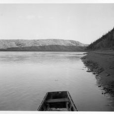
North Fork Koyukuk River, Mountain brook in Gates of The Arctic National Park, Alaska, US

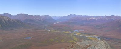
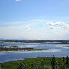
The North Fork Koyukuk River is a waterway that flows about 102 miles through glacially carved valleys in Gates of the Arctic National Park in Alaska. The river originates at the Continental Divide in the Endicott Mountains and runs southward through pristine wilderness.

The river valley contains archaeological sites that show people lived here when the last ice age ended, at a time when parts of the area remained free of glaciers. This early settlement marks one of the oldest known human presences in this region.

The river takes its name from the Koyukuk Athabaskan peoples who have lived in this region for thousands of years and shaped the land through their continuous presence. Visitors can observe traces of this long settlement along the banks and understand the deep connection between people and wilderness that remains visible today.

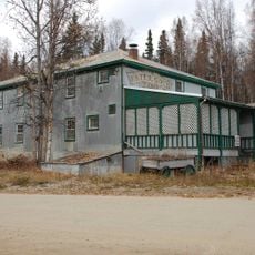
Reaching this river requires using a flight service from Bettles or Coldfoot, as there are no roads to the area. Visitors should come well prepared and understand that boat trips feature varying water conditions, from calm stretches to faster rapids.

The river flows between two distinctive mountain formations, Frigid Crags and Boreal Mountain, with Mount Doonerak reaching about 7,610 feet as the highest peak along its course. These striking summits shape the landscape and serve as notable landmarks for travelers.

GPS coordinates: 67.46062,-150.84786

Latest update: December 14, 2025 15:00

Photos
Around this place
Fairbanks Gold Rush
United States of America

Fairbanks Gold Rush

311.9 km
University of Alaska Museum of the North
United States of America

University of Alaska Museum of the North

319.6 km
E. L. Patton Yukon River Bridge
United States of America

E. L. Patton Yukon River Bridge

183.5 km
Gates of the Arctic Wilderness
United States of America

Gates of the Arctic Wilderness

117.4 km
West Valley High School
United States of America

West Valley High School

320.6 km
Goldstream Dredge No. 8
United States of America

Goldstream Dredge No. 8

315.3 km
Yukon Flats National Wildlife Refuge
United States of America

Yukon Flats National Wildlife Refuge

246 km
Mount Igikpak
United States of America

Mount Igikpak

175.9 km
Arrigetch Peaks
United States of America

Arrigetch Peaks

142.4 km
White Mountains National Recreation Area
United States of America

White Mountains National Recreation Area

266 km
Creamer's Field Migratory Waterfowl Refuge
United States of America

Creamer's Field Migratory Waterfowl Refuge

320.5 km
Kanuti National Wildlife Refuge
United States of America

Kanuti National Wildlife Refuge

123.9 km
John River
United States of America

John River

51.8 km
Georgeson Botanical Garden
United States of America

Georgeson Botanical Garden

319.5 km
Elmer E. Rasmuson Library
United States of America

Elmer E. Rasmuson Library

320.2 km
Gallagher Flint Station Archeological Site
United States of America

Gallagher Flint Station Archeological Site

229.7 km
Itkillik River
United States of America

Itkillik River

199.1 km
Constitution Hall
United States of America

Constitution Hall

320.1 km
Walker Lake
United States of America

Walker Lake

155.5 km
Kanuti River
United States of America

Kanuti River

140.8 km
Peters Glacier (Brooks Range)
United States of America

Peters Glacier (Brooks Range)

315.2 km
Discovery Claim on Pedro Creek
United States of America

Discovery Claim on Pedro Creek

311.5 km
John Trigg Ester Library
United States of America

John Trigg Ester Library

317.7 km
Rainey's Cabin
United States of America

Rainey's Cabin

319.8 km
Rampart Canyon
United States of America

Rampart Canyon

235 km
Dall River
United States of America

Dall River

150.9 km
Tolovana River
United States of America

Tolovana River

268.1 km
Ester Camp Historic District
United States of America

Ester Camp Historic District

317.5 km
Show the full map
Reviews

Visited this place? Tap the stars to rate it and share your experience / photos with the community! Try now! You can cancel it anytime.

« North Fork Koyukuk River - Mountain brook in Gates of The Arctic National Park, Alaska, US » is provided by Around Us (aroundus.com). Images and texts are derived from Wikimedia project under a Creative Commons license. You are allowed to copy, distribute, and modify copies of this page, under the conditions set by the license, as long as this note is clearly visible.

Discover hidden gems everywhere you go!

From secret cafés to breathtaking viewpoints, skip the crowded tourist spots and find places that match your style. Our app makes it easy with voice search, smart filtering, route optimization, and insider tips from travelers worldwide. Download now for the complete mobile experience.

Around Us App Screenshot

A unique approach to discovering new places

Le Figaro

All the places worth exploring

France Info

A tailor-made excursion in just a few clicks

20 Minutes