Enable Location

We need your location to show you interesting places around you

Discover nearby places

Find interesting locations and hidden gems around you

Precise directions

Get accurate directions and distances to places

Your location is never shared with other users. It's only used when you tap the location button.

John River

Log in to your account

Start exploring — it's free

Trusted by 62,290 travelers worldwide

Continue with Google
Continue with Apple
or

We will send you a code to connect

By continuing, you accept our Terms and Conditions and our Privacy Policy

Check your inbox

We've sent a pincode in your inbox. Please enter the code below.

John River

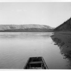
John River, Wild river in Brooks Range, Alaska

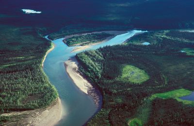
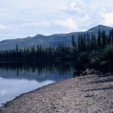
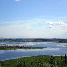
The John River is a waterway in Alaska's Brooks Range that flows for over 200 kilometers from the Endicott Mountains through open tundra and forested valleys until it meets the Koyukuk River near Bettles Field. Along its course, the river carves through varied terrain shaped by glaciation and seasonal weather patterns.

The river valley contains evidence of human settlement spanning multiple periods from the earliest hunting societies to modern times. This long record shows that the region has sustained human communities across countless generations.

The river flows through lands inhabited for thousands of years by Inupiat and Athapaskan peoples. These communities continue to live with the river, using it as a vital corridor through their territory.

Water conditions vary along the river depending on the season and location, with stronger currents in upper sections and calmer stretches downstream. Visitors should prepare for cold water and unpredictable weather typical of the Arctic environment.

The river flows through a notably narrow mountain corridor less than 2 kilometers wide that serves as a critical migration passage for three separate caribou herds. During migration seasons, travelers may witness thousands of these animals moving through the region at once.

The community of curious travelers

AroundUs brings together thousands of curated places, local tips, and hidden gems, enriched daily by 60,000 contributors worldwide.

Start exploring
GPS coordinates
67.44858,-152.06006
Latest update
December 13, 2025 17:05
Around this place
Kobuk Valley National Park
United States of America

Kobuk Valley National Park

307.8 km
Fairbanks Gold Rush
United States of America

Fairbanks Gold Rush

340.4 km
E. L. Patton Yukon River Bridge
United States of America

E. L. Patton Yukon River Bridge

203.5 km
Gates of the Arctic Wilderness
United States of America

Gates of the Arctic Wilderness

84 km
Goldstream Dredge No. 8
United States of America

Goldstream Dredge No. 8

342.4 km
Yukon Flats National Wildlife Refuge
United States of America

Yukon Flats National Wildlife Refuge

292.2 km
Mount Igikpak
United States of America

Mount Igikpak

124.2 km
Arrigetch Peaks
United States of America

Arrigetch Peaks

90.6 km
White Mountains National Recreation Area
United States of America

White Mountains National Recreation Area

296 km
Noatak Wilderness
United States of America

Noatak Wilderness

322.9 km
Kanuti National Wildlife Refuge
United States of America

Kanuti National Wildlife Refuge

115.3 km
Koyukuk National Wildlife Refuge
United States of America

Koyukuk National Wildlife Refuge

286.1 km
Selawik National Wildlife Refuge
United States of America

Selawik National Wildlife Refuge

323.4 km
Nowitna National Wildlife Refuge
United States of America

Nowitna National Wildlife Refuge

321.8 km
Georgeson Botanical Garden
United States of America

Georgeson Botanical Garden

344.9 km
North Fork Koyukuk River
United States of America

North Fork Koyukuk River

51.8 km
Selawik River
United States of America

Selawik River

294.4 km
Gallagher Flint Station Archeological Site
United States of America

Gallagher Flint Station Archeological Site

254 km
Onion Portage Archeological District
United States of America

Onion Portage Archeological District

271 km
Itkillik River
United States of America

Itkillik River

209.6 km
Walker Lake
United States of America

Walker Lake

105.3 km
Kanuti River
United States of America

Kanuti River

138.1 km
Discovery Claim on Pedro Creek
United States of America

Discovery Claim on Pedro Creek

339.9 km
John Trigg Ester Library
United States of America

John Trigg Ester Library

342 km
Rampart Canyon
United States of America

Rampart Canyon

238.3 km
Salmon River
United States of America

Salmon River

328.4 km
Dall River
United States of America

Dall River

177.2 km
Tolovana River
United States of America

Tolovana River

289 km
Show the full map
« John River - Wild river in Brooks Range, Alaska » is provided by Around Us (aroundus.com). Images and texts are derived from Wikimedia project under a Creative Commons license. You are allowed to copy, distribute, and modify copies of this page, under the conditions set by the license, as long as this note is clearly visible.

Discover hidden gems everywhere you go!

From secret cafés to breathtaking viewpoints, skip the crowded tourist spots and find places that match your style. Our app makes it easy with voice search, smart filtering, route optimization, and insider tips from travelers worldwide. Download now for the complete mobile experience.

Around Us App Screenshot

A unique approach to discovering new places

Le Figaro

All the places worth exploring

France Info

A tailor-made excursion in just a few clicks

20 Minutes

Around Us
Travel Guide & Maps
Download

Send to your phone

QR Code
1

Open the camera app on your mobile.

2

Point at the QR code with your camera. A notification will appear.

3

Tap the notification to open the link.