·

Enable Location

We need your location to show you interesting places around you

Discover nearby places

Find interesting locations and hidden gems around you

Precise directions

Get accurate directions and distances to places

Your location is never shared with other users. It's only used when you tap the location button.

Chamisso Wilderness

Log in to your account

Start exploring — it's free

Trusted by 62,654 travelers worldwide

Continue with Google
Continue with Apple
or

We will send you a code to connect

By continuing, you accept our Terms and Conditions and our Privacy Policy

Check your inbox

We've sent a pincode in your inbox. Please enter the code below.

Chamisso Wilderness

Chamisso Wilderness, Protected wilderness area in Kotzebue Sound, Alaska, US.

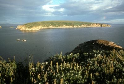
Chamisso Wilderness is a protected area in Kotzebue Sound containing Chamisso Island and Puffin Island, where steep cliffs rise about 226 feet above the Chukchi Sea. The site spans roughly 455 acres and is surrounded by cold Arctic waters.

The area received federal protection as a wilderness section of Alaska Maritime National Wildlife Refuge in 1975. This designation recognized the ecological importance of these remote Arctic islands.

The Inupiat people have used the waters around the islands for generations to gather bird eggs and secure traditional food sources. This practice remains an important part of their way of life and connection to the land today.

Visitors should prepare for extreme weather conditions, as the location receives about 185 centimeters of precipitation annually and winters are very cold. The best time to explore is summer, when temperatures are more moderate.

Horned puffins nest here in large colonies on the steep cliffs, creating an impressive spectacle during breeding season. Divers and birdwatchers come during the warmer months to observe this flurry of bird activity.

The community of curious travelers

AroundUs brings together thousands of curated places, local tips, and hidden gems, enriched daily by 60,000 contributors worldwide.

Start exploring
Location
Inception
1975
GPS coordinates
66.22444,-161.82500
Latest update
December 14, 2025 16:40
Around this place
Kobuk Valley National Park
United States of America

Kobuk Valley National Park

184.7 km
United States of America

Ipiutak Site

318.8 km
Trail Creek Caves
United States of America

Trail Creek Caves

86.7 km
Noatak Wilderness
United States of America

Noatak Wilderness

227.2 km
Koyukuk National Wildlife Refuge
United States of America

Koyukuk National Wildlife Refuge

252.2 km
Selawik National Wildlife Refuge
United States of America

Selawik National Wildlife Refuge

125 km
Cape Nome Mining District Discovery Sites
United States of America

Cape Nome Mining District Discovery Sites

247.3 km
Unalakleet River
United States of America

Unalakleet River

264 km
Old St. Joseph's Catholic Church
United States of America

Old St. Joseph's Catholic Church

253.9 km
Selawik River
United States of America

Selawik River

156.9 km
Nome River
United States of America

Nome River

237.6 km
Snake River
United States of America

Snake River

244.1 km
Onion Portage Archeological District
United States of America

Onion Portage Archeological District

183.3 km
Wales Site
United States of America

Wales Site

292.4 km
Kougarok River
United States of America

Kougarok River

155.7 km
Squirrel River
United States of America

Squirrel River

121.4 km
Kuzitrin River
United States of America

Kuzitrin River

155.2 km
Swanberg Dredge
United States of America

Swanberg Dredge

253.3 km
Solomon Roadhouse
United States of America

Solomon Roadhouse

221.4 km
Niukluk River
United States of America

Niukluk River

173 km
Iyatayet Site
United States of America

Iyatayet Site

202.6 km
Kugruk River
United States of America

Kugruk River

51.8 km
Shishmaref Inlet
United States of America

Shishmaref Inlet

182.3 km
Salmon River
United States of America

Salmon River

169.1 km
Noxapaga River
United States of America

Noxapaga River

123.8 km
Bureau of Indian Affairs Unalakleet School
United States of America

Bureau of Indian Affairs Unalakleet School

266.5 km
Kugururok River
United States of America

Kugururok River

234.5 km
Bering Land Bridge Visitor Center
United States of America

Bering Land Bridge Visitor Center

254.1 km
Show the full map
« Chamisso Wilderness - Protected wilderness area in Kotzebue Sound, Alaska, US » is provided by Around Us (aroundus.com). Images and texts are derived from Wikimedia project under a Creative Commons license. You are allowed to copy, distribute, and modify copies of this page, under the conditions set by the license, as long as this note is clearly visible.

Discover hidden gems everywhere you go!

From secret cafés to breathtaking viewpoints, skip the crowded tourist spots and find places that match your style. Our app makes it easy with voice search, smart filtering, route optimization, and insider tips from travelers worldwide. Download now for the complete mobile experience.

Around Us App Screenshot

A unique approach to discovering new places

Le Figaro

All the places worth exploring

France Info

A tailor-made excursion in just a few clicks

20 Minutes

Around Us
Travel Guide & Maps
Download

Send to your phone

QR Code
1

Open the camera app on your mobile.

2

Point at the QR code with your camera. A notification will appear.

3

Tap the notification to open the link.