Cape Nome Mining District Discovery Sites

Log in to your account

AroundUs is a community-driven map of interesting places, built by curious explorers like you. It grows with every review, story, and photo you share.
Connect to save your favorite spots, contribute locations, and create personalized routes.
Continue with Google
Continue with Apple
Continue with X
Continue with Facebook
Continue with email
By continuing, you accept our Terms and Conditions and our Privacy Policy
Create an account
Add to collection
Map
Suggest a change
Share

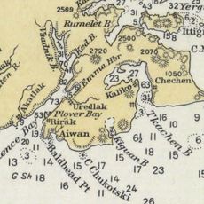
Cape Nome Mining District Discovery Sites, Mining historic district in Nome Census Area, United States.

The Cape Nome Mining District is a gold mining area in western Alaska spanning multiple discovery sites from the late 1800s. The district includes several named claims such as Anvil Creek, Erik Lindblom Placer, Snow Creek Placer, and Nome Beach, each a focal point where prospectors worked the land.

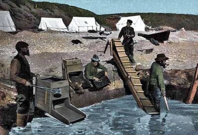
Gold was first discovered at Anvil Creek in September 1898, triggering one of Alaska's largest mining movements. This discovery transformed a remote region into a major gold extraction center that drew prospectors from across North America.

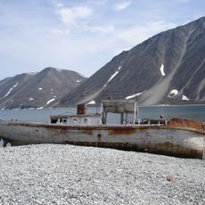
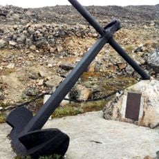
The site shaped Nome's identity as a gold rush town, where visitors today can see old mining equipment and abandoned claims scattered across the landscape. These remnants tell the story of the daily work and harsh conditions prospectors endured while seeking their fortunes.

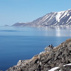
The site sits in a remote part of western Alaska and is accessible on foot, but requires preparation for harsh weather and challenging terrain. Visitors should bring sturdy gear and appropriate clothing since facilities in the area are limited.

The district experienced an unusually brief but intense mining boom, with most deposits exhausted within roughly two decades of discovery. Today it stands as one of few places where visitors can see the physical scars of the gold rush alongside the now-quiet streams and creeks that once flowed with riches.

Location: Nome Census Area

GPS coordinates: 64.56360,-165.37100

Latest update: December 14, 2025 12:21

Photos
Around this place
Whale Bone Alley
Russian Federation

Whale Bone Alley

341.3 km
Beringia National Park
Russian Federation

Beringia National Park

380.9 km
Monument to Semyon Dezhnev
Russian Federation

Monument to Semyon Dezhnev

258.8 km
Innoko National Wildlife Refuge
United States of America

Innoko National Wildlife Refuge

366.3 km
Trail Creek Caves
United States of America

Trail Creek Caves

164.4 km
Selawik National Wildlife Refuge
United States of America

Selawik National Wildlife Refuge

363.2 km
Unalakleet River
United States of America

Unalakleet River

270.1 km
Old St. Joseph's Catholic Church
United States of America

Old St. Joseph's Catholic Church

7.3 km
Nome River
United States of America

Nome River

10.1 km
Snake River
United States of America

Snake River

9.3 km
Chamisso Wilderness
United States of America

Chamisso Wilderness

247.3 km
Wales Site
United States of America

Wales Site

172.3 km
Kougarok River
United States of America

Kougarok River

105.4 km
Squirrel River
United States of America

Squirrel River

358.6 km
Kuzitrin River
United States of America

Kuzitrin River

95.2 km
Christ Church Mission
United States of America

Christ Church Mission

332.4 km
Swanberg Dredge
United States of America

Swanberg Dredge

7.9 km
Solomon Roadhouse
United States of America

Solomon Roadhouse

44.5 km
Niukluk River
United States of America

Niukluk River

80.3 km
Iyatayet Site
United States of America

Iyatayet Site

185.7 km
Kugruk River
United States of America

Kugruk River

195.5 km
Shishmaref Inlet
United States of America

Shishmaref Inlet

191.4 km
Noxapaga River
United States of America

Noxapaga River

130 km
Bureau of Indian Affairs Unalakleet School
United States of America

Bureau of Indian Affairs Unalakleet School

235 km
Slavyanka Cove
Russian Federation

Slavyanka Cove

383 km
Историко-культурный комплекс Пловер
Russian Federation

Историко-культурный комплекс Пловер

383.5 km
Памятный знак в честь 250-летия Первой Камчатской экспедиции (Провидения)
Russian Federation

Памятный знак в честь 250-летия Первой Камчатской экспедиции (Провидения)

377.8 km
Bering Land Bridge Visitor Center
United States of America

Bering Land Bridge Visitor Center

7.5 km
Show the full map
Reviews

Visited this place? Tap the stars to rate it and share your experience / photos with the community! Try now! You can cancel it anytime.

« Cape Nome Mining District Discovery Sites - Mining historic district in Nome Census Area, United States » is provided by Around Us (aroundus.com). Images and texts are derived from Wikimedia project under a Creative Commons license. You are allowed to copy, distribute, and modify copies of this page, under the conditions set by the license, as long as this note is clearly visible.

Discover hidden gems everywhere you go!

From secret cafés to breathtaking viewpoints, skip the crowded tourist spots and find places that match your style. Our app makes it easy with voice search, smart filtering, route optimization, and insider tips from travelers worldwide. Download now for the complete mobile experience.

Around Us App Screenshot

A unique approach to discovering new places

Le Figaro

All the places worth exploring

France Info

A tailor-made excursion in just a few clicks

20 Minutes