Enable Location

We need your location to show you interesting places around you

Discover nearby places

Find interesting locations and hidden gems around you

Precise directions

Get accurate directions and distances to places

Your location is never shared with other users. It's only used when you tap the location button.

Kougarok River

Log in to your account

Start exploring — it's free

Trusted by 61,789 travelers worldwide

Continue with Google
Continue with Apple
or

We will send you a code to connect

By continuing, you accept our Terms and Conditions and our Privacy Policy

Check your inbox

We've sent a pincode in your inbox. Please enter the code below.

Kougarok River

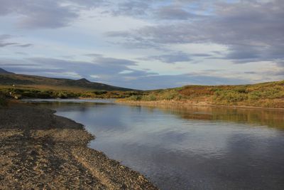
Kougarok River, Small river in Nome, Alaska

Description

The Kougarok River is a river on the Seward Peninsula that flows south and merges with the Kuzitrin River system. The Nome-Taylor Highway runs alongside it, providing access to this remote waterway through the landscape.

History

During the early 1900s, the river attracted gold miners who set up operations along its banks. These mining activities became part of the larger gold rush that shaped Alaska's development.

Culture

The river's name comes from the Inupiaq word "Kuuguraq", showing how indigenous peoples named the waterways around them. Today, this linguistic heritage remains visible in how the region identifies its natural features.

Practical

The Nome-Taylor Highway offers the best viewing access to the river from your vehicle. Visitors should prepare for the remote setting and bring suitable gear for the harsh conditions typical of this region.

Did you know?

The river forms where two creeks meet in elevated terrain and gradually descends until reaching near sea level. This change in elevation creates different landscapes and water conditions throughout its entire course.

Location
GPS coordinates
65.46692,-164.69798
Latest update
December 14, 2025 18:04

AroundUs brings together thousands of curated places, local tips, and hidden gems, enriched daily by 60,000 contributors worldwide. Discover all places nearby (Nome).

Around this place
Kobuk Valley National Park
United States of America

Kobuk Valley National Park

333.7 km
United States of America

Ipiutak Site

333.3 km
Monument to Semyon Dezhnev
Russian Federation

Monument to Semyon Dezhnev

237.2 km
Trail Creek Caves
United States of America

Trail Creek Caves

69.1 km
Noatak Wilderness
United States of America

Noatak Wilderness

366.8 km
Selawik National Wildlife Refuge
United States of America

Selawik National Wildlife Refuge

279.2 km
Cape Nome Mining District Discovery Sites
United States of America

Cape Nome Mining District Discovery Sites

105.4 km
Unalakleet River
United States of America

Unalakleet River

279.6 km
Old St. Joseph's Catholic Church
United States of America

Old St. Joseph's Catholic Church

112.7 km
Selawik River
United States of America

Selawik River

308.5 km
Nome River
United States of America

Nome River

95.5 km
Snake River
United States of America

Snake River

99.2 km
Chamisso Wilderness
United States of America

Chamisso Wilderness

155.7 km
Onion Portage Archeological District
United States of America

Onion Portage Archeological District

338.9 km
Wales Site
United States of America

Wales Site

156.9 km
Squirrel River
United States of America

Squirrel River

257.3 km
Kuzitrin River
United States of America

Kuzitrin River

22.3 km
Swanberg Dredge
United States of America

Swanberg Dredge

112.9 km
Solomon Roadhouse
United States of America

Solomon Roadhouse

101.7 km
Niukluk River
United States of America

Niukluk River

69.4 km
Iyatayet Site
United States of America

Iyatayet Site

190.8 km
Kugruk River
United States of America

Kugruk River

106.4 km
Shishmaref Inlet
United States of America

Shishmaref Inlet

104.5 km
Salmon River
United States of America

Salmon River

315.6 km
Noxapaga River
United States of America

Noxapaga River

32.2 km
Bureau of Indian Affairs Unalakleet School
United States of America

Bureau of Indian Affairs Unalakleet School

257.4 km
Kugururok River
United States of America

Kugururok River

349.7 km
Bering Land Bridge Visitor Center
United States of America

Bering Land Bridge Visitor Center

112.9 km
Show the full map
« Kougarok River - Small river in Nome, Alaska » is provided by Around Us (aroundus.com). Images and texts are derived from Wikimedia project under a Creative Commons license. You are allowed to copy, distribute, and modify copies of this page, under the conditions set by the license, as long as this note is clearly visible.

Discover hidden gems everywhere you go!

From secret cafés to breathtaking viewpoints, skip the crowded tourist spots and find places that match your style. Our app makes it easy with voice search, smart filtering, route optimization, and insider tips from travelers worldwide. Download now for the complete mobile experience.

Around Us App Screenshot

A unique approach to discovering new places

Le Figaro

All the places worth exploring

France Info

A tailor-made excursion in just a few clicks

20 Minutes

Around Us
Travel Guide & Maps
Download

Send to your phone

QR Code
1

Open the camera app on your mobile.

2

Point at the QR code with your camera. A notification will appear.

3

Tap the notification to open the link.