Chest opened
+${chestReward.xp} XP
Explorer
NOUVEAU ×${chestReward.collectible.quantity}
tapez pour fermer
Chest locked

Open chests in the app

Around Us is built for your phone — chests unlock when you walk, explore and capture nearby places.

Enable Location

We need your location to show you interesting places around you

Discover nearby places

Find interesting locations and hidden gems around you

Precise directions

Get accurate directions and distances to places

Your location is never shared with other users. It's only used when you tap the location button.

Lavrentiya

Log in to your account

Start exploring — it's free

Trusted by 72,932 travelers worldwide

Continue with Google
Continue with Apple
or

We will send you a code to connect

By continuing, you accept our Terms and Conditions and our Privacy Policy

Check your inbox

We've sent a pincode in your inbox. Please enter the code below.

Discussion Reviews 2 Photos
24.5k Popularity

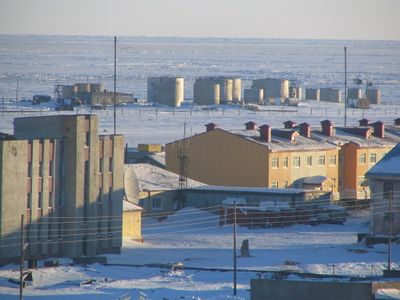
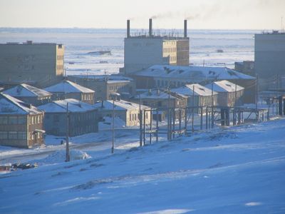
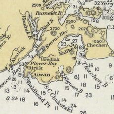
Lavrentiya, Administrative center in Chukotsky District, Russia

Lavrentiya is an administrative center situated on a bay of the same name near the Bering Strait. The settlement includes a district court, hospital, school, telecommunications center, and serves as a regional hub for air transport.

The settlement was established in 1928 when a cultural center was built to provide education to the area's indigenous population. This early institution shaped its development as an administrative and educational hub.

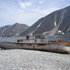
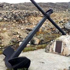
The village hosts an annual celebration of whales and traditional skin boats that ties residents to their maritime past through friendly competitions. These events show how deeply water-based traditions remain part of daily life here.

The village is in a remote location and is best reached by air transport. Visitors should prepare for harsh weather conditions and check ahead before traveling, as access can be seasonal.

The bay was named after Saint Lawrence because British Captain James Cook reached the region on that saint's feast day in 1778. This naming by a foreign explorer connects local history to broader voyages of discovery.

The community of curious travelers

AroundUs brings together thousands of curated places, local tips, and hidden gems, enriched daily by 60,000 contributors worldwide.

Start exploring
Inception
1928
GPS coordinates
65.58415,-170.98890
Latest update
December 20, 2025 12:36
Around this place
Whale Bone Alley
Russian Federation

Whale Bone Alley

127.1 km
Beringia National Park
Russian Federation

Beringia National Park

173.8 km
United States of America

Ipiutak Site

356.6 km
Monument to Semyon Dezhnev
Russian Federation

Monument to Semyon Dezhnev

75.9 km
Trail Creek Caves
United States of America

Trail Creek Caves

347.6 km
Pilgrim Hot Springs
United States of America

Pilgrim Hot Springs

286.9 km
Cape Nome Mining District Discovery Sites
United States of America

Cape Nome Mining District Discovery Sites

286.9 km
Old St. Joseph's Catholic Church
United States of America

Old St. Joseph's Catholic Church

288.5 km
Nome River
United States of America

Nome River

287.1 km
Snake River
United States of America

Snake River

279.4 km
Chamisso Wilderness
United States of America

Chamisso Wilderness

422.1 km
Wales Site
United States of America

Wales Site

133.6 km
Kougarok River
United States of America

Kougarok River

290.3 km
Squirrel River
United States of America

Squirrel River

477.7 km
Kuzitrin River
United States of America

Kuzitrin River

306.4 km
Swanberg Dredge
United States of America

Swanberg Dredge

290.6 km
Solomon Roadhouse
United States of America

Solomon Roadhouse

327.6 km
Niukluk River
United States of America

Niukluk River

336.9 km
Iyatayet Site
United States of America

Iyatayet Site

464.1 km
Kugruk River
United States of America

Kugruk River

384.4 km
Shishmaref Inlet
United States of America

Shishmaref Inlet

243.7 km
Noxapaga River
United States of America

Noxapaga River

318.1 km
Bureau of Indian Affairs Unalakleet School
United States of America

Bureau of Indian Affairs Unalakleet School

520.4 km
Slavyanka Cove
Russian Federation

Slavyanka Cove

175.1 km
Историко-культурный комплекс Пловер
Russian Federation

Историко-культурный комплекс Пловер

175.9 km
Kugururok River
United States of America

Kugururok River

517.8 km
Памятный знак в честь 250-летия Первой Камчатской экспедиции (Провидения)
Russian Federation

Памятный знак в честь 250-летия Первой Камчатской экспедиции (Провидения)

167.7 km
Памятник «Авиаторам — первопроходцам и защитникам неба Чукотки» (Угольные Копи)
Russian Federation

Памятник «Авиаторам — первопроходцам и защитникам неба Чукотки» (Угольные Копи)

536.8 km
Show the full map
Reviews
Share your experience

No review yet

Discussions
Start a discussion...

No discussion yet

« Lavrentiya - Administrative center in Chukotsky District, Russia » is provided by Around Us (aroundus.com). Images and texts are derived from Wikimedia project under a Creative Commons license. You are allowed to copy, distribute, and modify copies of this page, under the conditions set by the license, as long as this note is clearly visible.

Discover hidden gems everywhere you go!

From secret cafés to breathtaking viewpoints, skip the crowded tourist spots and find places that match your style. Our app makes it easy with voice search, smart filtering, route optimization, and insider tips from travelers worldwide. Download now for the complete mobile experience.

Around Us App Screenshot

A unique approach to discovering new places

Le Figaro

All the places worth exploring

France Info

A tailor-made excursion in just a few clicks

20 Minutes

Around Us
Travel Guide & Maps
Download

Send to your phone

QR Code
1

Open the camera app on your mobile.

2

Point at the QR code with your camera. A notification will appear.

3

Tap the notification to open the link.