Enable Location

We need your location to show you interesting places around you

Discover nearby places

Find interesting locations and hidden gems around you

Precise directions

Get accurate directions and distances to places

Your location is never shared with other users. It's only used when you tap the location button.

Twentieth Street Historic District

Log in to your account

Start exploring — it's free

Trusted by 61,368 travelers worldwide

Continue with Google
Continue with Apple
or

We will send you a code to connect

By continuing, you accept our Terms and Conditions and our Privacy Policy

Check your inbox

We've sent a pincode in your inbox. Please enter the code below.

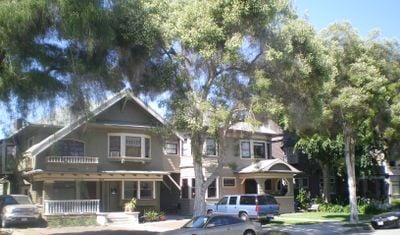
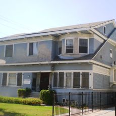
Twentieth Street Historic District, Historic district in West Adams, Los Angeles, California, US.

Description

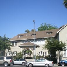
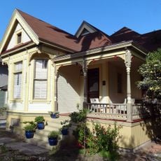
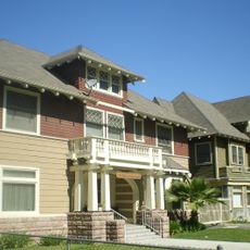
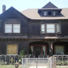
Twentieth Street Historic District is a collection of residential buildings in Craftsman and Prairie styles lining the 900 block in West Adams. The area contains houses from different building phases, each showing distinctive features from its era.

History

Developers began constructing the houses between 1900 and 1908, creating a residential neighborhood that grew in importance. The district gained recognition in 1991 when it was added to the National Register of Historic Places.

Culture

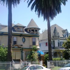
The street displays a blend of Prairie, Craftsman, and Victorian design elements that reflect local building traditions. Visitors can see today how different architectural approaches coexist harmoniously along the block.

Practical

The district sits about 0.75 mile (1.2 kilometers) north of the University of Southern California, positioned between Washington Boulevard and Toberman and Oak Streets. The area is easy to walk through and offers good views of the house facades from the street.

Did you know?

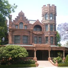
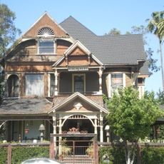
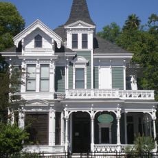
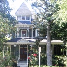
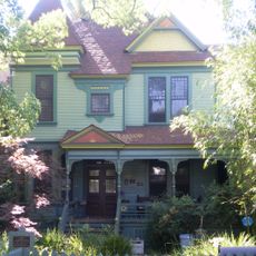
One residence stands out for its unusual Transitional Victorian architecture featuring an innovative overlapping board frame design. The building also displays a distinctive hip-roofed turret with tent-like configuration, making it a noteworthy architectural study.

Location
GPS coordinates
34.03583,-118.27889
Latest update
December 14, 2025 16:48

AroundUs brings together thousands of curated places, local tips, and hidden gems, enriched daily by 60,000 contributors worldwide. Discover all places nearby (California).

Around this place
Peacock Theater
United States of America

Peacock Theater

1.4 km
Shrine Auditorium
United States of America

Shrine Auditorium

1.4 km
Grand Olympic Auditorium
United States of America

Grand Olympic Auditorium

1 km
Bob Hope Patriotic Hall
United States of America

Bob Hope Patriotic Hall

731 m
Stimson House
United States of America

Stimson House

769 m
Casa de Rosas
United States of America

Casa de Rosas

708 m
Uytengsu Aquatics Center
United States of America

Uytengsu Aquatics Center

1.6 km
ONE National Gay & Lesbian Archives
United States of America

ONE National Gay & Lesbian Archives

586 m
Conga Room
United States of America

Conga Room

1.6 km
AT&T Center
United States of America

AT&T Center

1.6 km
North University Park Historic District
United States of America

North University Park Historic District

803 m
Velaslavasay Panorama
United States of America

Velaslavasay Panorama

563 m
South Bonnie Brae Tract Historic District
United States of America

South Bonnie Brae Tract Historic District

1.6 km
Second Church of Christ, Scientist
United States of America

Second Church of Christ, Scientist

846 m
First Church of Christ, Scientist
United States of America

First Church of Christ, Scientist

1.1 km
John B. Kane Residence
United States of America

John B. Kane Residence

366 m
St. James Park Historic District
United States of America

St. James Park Historic District

297 m
Leavey Library
United States of America

Leavey Library

1.6 km
Forthmann House
United States of America

Forthmann House

893 m
Miller and Herriott House
United States of America

Miller and Herriott House

832 m
Menlo Avenue-West Twenty-ninth Street Historic District
United States of America

Menlo Avenue-West Twenty-ninth Street Historic District

1.1 km
Machell-Seaman House
United States of America

Machell-Seaman House

436 m
Edward Alexander Kelley Hackett House
United States of America

Edward Alexander Kelley Hackett House

1.1 km
Birthplace of Adlai E. Stevenson II
United States of America

Birthplace of Adlai E. Stevenson II

785 m
Ritz-Carlton/Marriott Marquis Los Angeles
United States of America

Ritz-Carlton/Marriott Marquis Los Angeles

1.5 km
Oceanwide Plaza I
United States of America

Oceanwide Plaza I

1.5 km
Oceanwide Plaza II
United States of America

Oceanwide Plaza II

1.5 km
Oceanwide Plaza III
United States of America

Oceanwide Plaza III

1.4 km
Show the full map
« Twentieth Street Historic District - Historic district in West Adams, Los Angeles, California, US » is provided by Around Us (aroundus.com). Images and texts are derived from Wikimedia project under a Creative Commons license. You are allowed to copy, distribute, and modify copies of this page, under the conditions set by the license, as long as this note is clearly visible.

Discover hidden gems everywhere you go!

From secret cafés to breathtaking viewpoints, skip the crowded tourist spots and find places that match your style. Our app makes it easy with voice search, smart filtering, route optimization, and insider tips from travelers worldwide. Download now for the complete mobile experience.

Around Us App Screenshot

A unique approach to discovering new places

Le Figaro

All the places worth exploring

France Info

A tailor-made excursion in just a few clicks

20 Minutes

Around Us
Travel Guide & Maps
Download

Send to your phone

QR Code
1

Open the camera app on your mobile.

2

Point at the QR code with your camera. A notification will appear.

3

Tap the notification to open the link.