Enable Location

We need your location to show you interesting places around you

Discover nearby places

Find interesting locations and hidden gems around you

Precise directions

Get accurate directions and distances to places

Your location is never shared with other users. It's only used when you tap the location button.

Interstate 405

Log in to your account

Start exploring — it's free

Trusted by 63,047 travelers worldwide

Continue with Google
Continue with Apple
or

We will send you a code to connect

By continuing, you accept our Terms and Conditions and our Privacy Policy

Check your inbox

We've sent a pincode in your inbox. Please enter the code below.

Interstate 405
Discussion Reviews 1 Photos
111k Popularity

Interstate 405, Interstate bypass in Los Angeles and Orange Counties, United States.

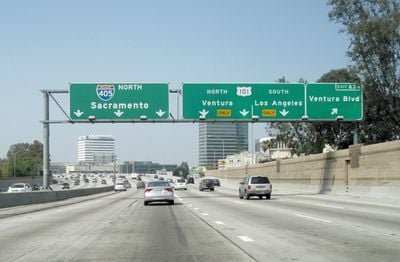
Interstate 405 is a road in Los Angeles County and Orange County, California, stretching roughly 72 miles (116 km) through Southern California. It links residential neighborhoods with business districts, universities, and three major airports along its path.

Work on the road began in 1954, and the first sections opened in 1957 under the name Route 7. The designation changed later to reflect its role as an Interstate Highway.

Many commuters plan their day around traffic patterns on this road, checking conditions before leaving home or work. Radio stations dedicate regular segments to reporting delays and incidents along its length.

Express lanes run between Costa Mesa and the county line, with pricing that adjusts according to current traffic levels. These lanes offer an alternative when congestion builds up during peak hours.

The stretch between the Seal Beach exits sees about 374,000 vehicles pass through each day. This makes it one of the most traveled freeway sections in the entire country.

The community of curious travelers

AroundUs brings together thousands of curated places, local tips, and hidden gems, enriched daily by 60,000 contributors worldwide.

Start exploring
Location
Inception
1964
GPS coordinates
33.82550,-118.22500
Latest update
December 12, 2025 22:42
Around this place
Mulholland Drive
United States of America

Mulholland Drive

41.9 km
Getty Center
United States of America

Getty Center

36.3 km
J. Paul Getty Museum
United States of America

J. Paul Getty Museum

36.2 km
Chartwell Mansion
United States of America

Chartwell Mansion

35.4 km
Pickfair
United States of America

Pickfair

34.5 km
Harold Lloyd Estate
United States of America

Harold Lloyd Estate

34.7 km
Sheats Goldstein Residence
United States of America

Sheats Goldstein Residence

35.6 km
Carolwood Pacific Railroad
United States of America

Carolwood Pacific Railroad

34.5 km
Sepulveda Dam
United States of America

Sepulveda Dam

44.3 km
Radford Studio Center
United States of America

Radford Studio Center

38.7 km
United States of America

Franklin Canyon Park

35.4 km
The Great Wall of Los Angeles
United States of America

The Great Wall of Los Angeles

43.1 km
Bel-Air Country Club
United States of America

Bel-Air Country Club

35 km
Coldwater Canyon
United States of America

Coldwater Canyon

35.5 km
Beverly Hills Women's Club
United States of America

Beverly Hills Women's Club

34.6 km
Bel Air Presbyterian Church
United States of America

Bel Air Presbyterian Church

41.6 km
The Japanese Garden
United States of America

The Japanese Garden

46.3 km
Bailey House – Case Study House
United States of America

Bailey House – Case Study House

35.9 km
Los Encinos State Historic Park
United States of America

Los Encinos State Historic Park

45 km
Virginia Robinson Gardens
United States of America

Virginia Robinson Gardens

34 km
United States of America

Van Nuys City Hall

44.9 km
Valley Beth Shalom
United States of America

Valley Beth Shalom

43.5 km
Cathedral of St. Mary Byzantine Catholic Church
United States of America

Cathedral of St. Mary Byzantine Catholic Church

44.1 km
North Hollywood Amelia Earhart Regional Library
United States of America

North Hollywood Amelia Earhart Regional Library

40.5 km
Saint Saviour's Chapel
United States of America

Saint Saviour's Chapel

39.1 km
Van Nuys Branch
United States of America

Van Nuys Branch

45 km
Valley Relics Museum
United States of America

Valley Relics Museum

50.1 km
UCLA University Residence
United States of America

UCLA University Residence

34.4 km
Show the full map
Reviews
Share your experience

No review yet

Discussions
Start a discussion...

No discussion yet

« Interstate 405 - Interstate bypass in Los Angeles and Orange Counties, United States » is provided by Around Us (aroundus.com). Images and texts are derived from Wikimedia project under a Creative Commons license. You are allowed to copy, distribute, and modify copies of this page, under the conditions set by the license, as long as this note is clearly visible.

Discover hidden gems everywhere you go!

From secret cafés to breathtaking viewpoints, skip the crowded tourist spots and find places that match your style. Our app makes it easy with voice search, smart filtering, route optimization, and insider tips from travelers worldwide. Download now for the complete mobile experience.

Around Us App Screenshot

A unique approach to discovering new places

Le Figaro

All the places worth exploring

France Info

A tailor-made excursion in just a few clicks

20 Minutes

Around Us
Travel Guide & Maps
Download

Send to your phone

QR Code
1

Open the camera app on your mobile.

2

Point at the QR code with your camera. A notification will appear.

3

Tap the notification to open the link.