Pacoima Dam

Log in to your account

AroundUs is a community-driven map of interesting places, built by curious explorers like you. It grows with every review, story, and photo you share.
Connect to save your favorite spots, contribute locations, and create personalized routes.
By continuing, you accept our Terms and Conditions and our Privacy Policy
Add to collection
Map
Suggest a change
Share

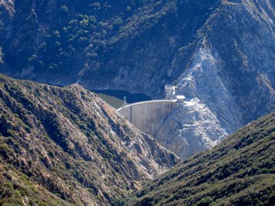
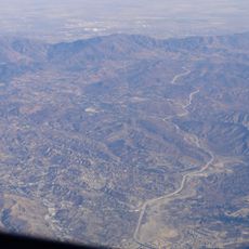
Pacoima Dam, Concrete arch dam in San Gabriel Mountains, USA.

Pacoima Dam is a concrete arch dam that spans a mountain creek valley in the San Gabriel range. Its curved structure is wedged between canyon walls to hold back water and provide storage for the surrounding region.

The dam was completed in 1928 as one of the tallest arch structures of its kind in the nation at that time. This construction marked an important step forward in how the region managed its water supply.

The structure represents an engineering milestone in California water management, connecting multiple generations of Los Angeles County residents to their water resources.

The mountain location means visitors should expect winding roads to reach the site. Spring and autumn offer the best conditions for seeing the structure and the landscape around it.

The dam is monitored by seismic sensors that track its movements and have recorded how it responds to earthquakes. This data has become valuable for understanding how arch dams behave during shaking.

Location: Los Angeles County

GPS coordinates: 34.33470,-118.39600

Latest update: December 10, 2025 20:07

Photos
Around this place
Mission San Fernando Rey de España
United States of America

Mission San Fernando Rey de España

9.1 km
Golden Oak Ranch
United States of America

Golden Oak Ranch

8.7 km
The Master's Seminary
United States of America

The Master's Seminary

12.9 km
Nethercutt Collection
United States of America

Nethercutt Collection

7 km
Mount Lukens, California
United States of America

Mount Lukens, California

16.2 km
Placerita Canyon State Park
United States of America

Placerita Canyon State Park

6.5 km
Soledad Canyon
United States of America

Soledad Canyon

16.6 km
Shepherd of the Hills Church
United States of America

Shepherd of the Hills Church

16.9 km
Portal of the Folded Wings Shrine to Aviation
United States of America

Portal of the Folded Wings Shrine to Aviation

16.4 km
Matadome
United States of America

Matadome

15.8 km
Rómulo Pico Adobe
United States of America

Rómulo Pico Adobe

9.8 km
Van Nuys City Hall
United States of America

Van Nuys City Hall

17.4 km
Convento Building
United States of America

Convento Building

9.1 km
Bolton Hall
United States of America

Bolton Hall

13.5 km
O'Melveny Park
United States of America

O'Melveny Park

11.8 km
San Fernando Gardens
United States of America

San Fernando Gardens

7.6 km
Sylmar Converter Station
United States of America

Sylmar Converter Station

8.2 km
California State University Northridge Botanic Garden
United States of America

California State University Northridge Botanic Garden

16.1 km
Lopez Adobe
United States of America

Lopez Adobe

7.3 km
Oviatt Library
United States of America

Oviatt Library

16.2 km
San Fernando Pioneer Memorial Cemetery
United States of America

San Fernando Pioneer Memorial Cemetery

5 km
St. Leon Cathedral
United States of America

St. Leon Cathedral

15.2 km
Valley Relics Museum
United States of America

Valley Relics Museum

16.5 km
William S. Hart Museum
United States of America

William S. Hart Museum

12.8 km
Playtime Co.
United States of America

Playtime Co.

17 km
Griffith Ranch Historical Monument
United States of America

Griffith Ranch Historical Monument

5.2 km
Chandler Valley Center Studios
United States of America

Chandler Valley Center Studios

14.3 km
Nature Center [Placerita State Park]
United States of America

Nature Center [Placerita State Park]

8.2 km
Show the full map
Reviews

Visited this place? Tap the stars to rate it and share your experience / photos with the community! Try now! You can cancel it anytime.

« Pacoima Dam - Concrete arch dam in San Gabriel Mountains, USA » is provided by Around Us (aroundus.com). Images and texts are derived from Wikimedia project under a Creative Commons license. You are allowed to copy, distribute, and modify copies of this page, under the conditions set by the license, as long as this note is clearly visible.

Discover hidden gems everywhere you go!

From secret cafés to breathtaking viewpoints, skip the crowded tourist spots and find places that match your style. Our app makes it easy with voice search, smart filtering, route optimization, and insider tips from travelers worldwide. Download now for the complete mobile experience.

Around Us App Screenshot

A unique approach to discovering new places

Le Figaro

All the places worth exploring

France Info

A tailor-made excursion in just a few clicks

20 Minutes