
Sylmar Converter Station, HVDC converter station in Sylmar, California, US
The Sylmar Converter Station is an HVDC converter station in the Sylmar neighborhood of Los Angeles, California. It converts direct current arriving from the Pacific Northwest into alternating current for distribution across the greater Los Angeles area.
The station opened in 1970 as part of one of the first major HVDC transmission projects in the US. The 1971 earthquake heavily damaged the facility, and after repairs it was later expanded to meet growing demand in the region.
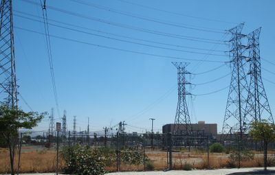
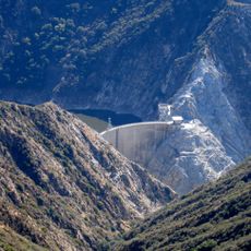
The station sits at the southern end of the Pacific DC Intertie, a long transmission line linking Southern California with the Pacific Northwest. Driving past, you can see the large outdoor transformers and towers that give a sense of how power moves across long distances.
The facility is closed to the public and cannot be visited directly. From nearby public roads, it is possible to see the outdoor equipment and get a sense of the overall scale of the installation.
One detail that surprises many people is that the transmission line connected here can move power in both directions, north to south and south to north, depending on where it is needed. This means the Pacific Northwest can send power to Los Angeles during dry seasons in the south, and the flow can reverse when conditions change.
The community of curious travelers
AroundUs brings together thousands of curated places, local tips, and hidden gems, enriched daily by 60,000 contributors worldwide.


![Nature Center [Placerita State Park]](https://img9.digsty.com/aUXxkLNKKsOqG0cCoGfQjUqw0qr3lud0HH33qdm8vTY/rs:fill:230:230:1/g:fp:0.5:0.5/czM6Ly9hcm91bmR1cy8xNC8xNjUwOTUwODEtMzA4MTBmM2UuanBn.jpg)
