Enable Location

We need your location to show you interesting places around you

Discover nearby places

Find interesting locations and hidden gems around you

Precise directions

Get accurate directions and distances to places

Your location is never shared with other users. It's only used when you tap the location button.

Soledad Canyon

Log in to your account

Start exploring — it's free

Trusted by 65,736 travelers worldwide

Continue with Google
Continue with Apple
or

We will send you a code to connect

By continuing, you accept our Terms and Conditions and our Privacy Policy

Check your inbox

We've sent a pincode in your inbox. Please enter the code below.

Soledad Canyon
Discussion Reviews 1 Photos
8.3k Popularity

Soledad Canyon, Natural canyon in Los Angeles County, California.

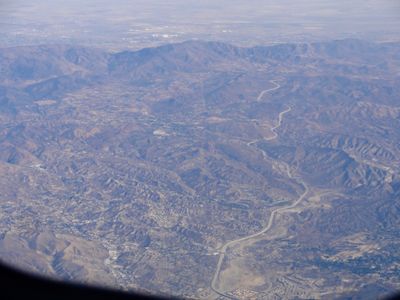
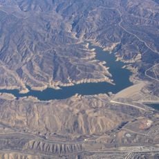
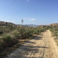
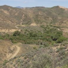
Soledad Canyon is a mountain passage in southern California, cutting between the Sierra Pelona Mountains and the San Gabriel Mountains through the Santa Clara River Valley. Steep rock walls rise on both sides of the canyon floor, where a road and a river run side by side through the narrow gap.

In 1876, the Southern Pacific Railroad laid tracks through Soledad Canyon, creating the first direct rail link between Los Angeles and San Francisco. The route opened up this difficult mountain crossing to regular freight and passenger traffic for the first time.

The name Soledad comes from the Spanish word for solitude, reflecting how isolated this passage felt to early settlers moving through the mountains. That sense of remoteness is still easy to feel today, with bare rock faces and sparse shrubs stretching along both sides of the road.

Soledad Canyon Road connects Santa Clarita to Acton and is the main road through the canyon, meeting State Route 14 at one end. Visiting in the cooler months is more comfortable, as the canyon gets very hot and exposed in summer with little shade along the way.

Sand and gravel mining ran through this canyon from 1921 to 1989, cutting deep into the hillsides and changing the shape of the terrain in ways that are still visible today. Because of this, parts of the canyon floor look quite different from a natural mountain valley, with flat terraces and exposed slopes left behind by the excavations.

The community of curious travelers

AroundUs brings together thousands of curated places, local tips, and hidden gems, enriched daily by 60,000 contributors worldwide.

Start exploring
Location
GPS coordinates
34.42420,-118.54100
Latest update
March 3, 2026 10:11
Reviews
Share your experience

No review yet

Discussions
Start a discussion...

No discussion yet

« Soledad Canyon - Natural canyon in Los Angeles County, California » is provided by Around Us (aroundus.com). Images and texts are derived from Wikimedia project under a Creative Commons license. You are allowed to copy, distribute, and modify copies of this page, under the conditions set by the license, as long as this note is clearly visible.

Discover hidden gems everywhere you go!

From secret cafés to breathtaking viewpoints, skip the crowded tourist spots and find places that match your style. Our app makes it easy with voice search, smart filtering, route optimization, and insider tips from travelers worldwide. Download now for the complete mobile experience.

Around Us App Screenshot

A unique approach to discovering new places

Le Figaro

All the places worth exploring

France Info

A tailor-made excursion in just a few clicks

20 Minutes

Around Us
Travel Guide & Maps
Download

Send to your phone

QR Code
1

Open the camera app on your mobile.

2

Point at the QR code with your camera. A notification will appear.

3

Tap the notification to open the link.