Enable Location

We need your location to show you interesting places around you

Discover nearby places

Find interesting locations and hidden gems around you

Precise directions

Get accurate directions and distances to places

Your location is never shared with other users. It's only used when you tap the location button.

Log in to your account

Save your favorite places
Create custom travel routes
Rate and review places
Access the full interactive map
Continue with Google
Continue with Apple
Continue with email
By continuing, you accept our Terms and Conditions and our Privacy Policy
Create an account

Martha McLean – Anza Narrows

Add to collection
Map
Suggest a change
Share

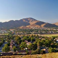
Martha McLean – Anza Narrows, Regional park by Santa Ana River in Riverside, California.

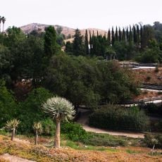
Martha McLean - Anza Narrows is a regional park along the Santa Ana River spanning 40 acres with trails and recreational areas positioned on a shaded bluff. The elevated terrain offers various activity zones including disc golf, hiking routes, and equestrian pathways.

The grounds mark where Juan Bautista de Anza's expeditions crossed the Santa Ana River in 1774 and 1776, establishing the first European passage through Riverside. This crossing became a key route for early settlement and development in the region.

The grounds connect visitors to the Juan Bautista de Anza National Historic Trail extending across Southern California through an on-site commemorative marker. The location reflects the early importance of this passage for European exploration in the region.

The park offers hiking, cycling, and equestrian trails suitable for different activity levels. An 18-hole disc golf course and reserved group picnic areas make it easy to spend half a day or a full day exploring.

The park is named after environmental activist Martha McLean, who worked with Ruth Anderson in the 1960s to fight river channelization. Their effort preserved this stretch from concrete barriers and created the open recreation space visitors enjoy today.

Location: California

GPS coordinates: 33.96280,-117.42800

Latest update: December 14, 2025 13:06

Photos
Around this place
Riverside International Raceway
United States of America

Riverside International Raceway

14.6 km
Auto Club Speedway
United States of America

Auto Club Speedway

15.5 km
Mission Inn
United States of America

Mission Inn

5.6 km
Mount Rubidoux
United States of America

Mount Rubidoux

4 km
Lake Mathews
United States of America

Lake Mathews

13.5 km
United States of America

Jurupa Oak

8.5 km
Lake Norconian Club
United States of America

Lake Norconian Club

13.6 km
Castle Park
United States of America

Castle Park

7.6 km
California Citrus State Historic Park
United States of America

California Citrus State Historic Park

7.5 km
Riverside Fox Theater
United States of America

Riverside Fox Theater

5.4 km
Harada House
United States of America

Harada House

6 km
University of California, Riverside Citrus Variety Collection
United States of America

University of California, Riverside Citrus Variety Collection

9 km
Riverside International Automotive Museum
United States of America

Riverside International Automotive Museum

10 km
Riverside Art Museum
United States of America

Riverside Art Museum

5.7 km
Riverside Municipal Auditorium
United States of America

Riverside Municipal Auditorium

5.7 km
University of California, Riverside Botanic Gardens
United States of America

University of California, Riverside Botanic Gardens

10 km
Jensen Alvarado Ranch
United States of America

Jensen Alvarado Ranch

3.5 km
Slover Mountain
United States of America

Slover Mountain

13.9 km
Heritage House
United States of America

Heritage House

3.2 km
UCR Soccer Stadium
United States of America

UCR Soccer Stadium

9.3 km
Victoria Avenue
United States of America

Victoria Avenue

4.9 km
Grand Boulevard
United States of America

Grand Boulevard

16.1 km
Fiesta Village Family Fun Park
United States of America

Fiesta Village Family Fun Park

15 km
Entomology Research Museum
United States of America

Entomology Research Museum

9.5 km
Museum of Riverside
United States of America

Museum of Riverside

5.5 km
First Congregational Church of Riverside
United States of America

First Congregational Church of Riverside

5.7 km
Mount Jurupa
United States of America

Mount Jurupa

7.9 km
Colton Carnegie Library
United States of America

Colton Carnegie Library

15.3 km
Show the full map
Reviews

Visited this place? Tap the stars to rate it and share your experience / photos with the community! Try now! You can cancel it anytime.

« Martha McLean – Anza Narrows - Regional park by Santa Ana River in Riverside, California » is provided by Around Us (aroundus.com). Images and texts are derived from Wikimedia project under a Creative Commons license. You are allowed to copy, distribute, and modify copies of this page, under the conditions set by the license, as long as this note is clearly visible.

Discover hidden gems everywhere you go!

From secret cafés to breathtaking viewpoints, skip the crowded tourist spots and find places that match your style. Our app makes it easy with voice search, smart filtering, route optimization, and insider tips from travelers worldwide. Download now for the complete mobile experience.

Around Us App Screenshot

A unique approach to discovering new places

Le Figaro

All the places worth exploring

France Info

A tailor-made excursion in just a few clicks

20 Minutes