Enable Location

We need your location to show you interesting places around you

Discover nearby places

Find interesting locations and hidden gems around you

Precise directions

Get accurate directions and distances to places

Your location is never shared with other users. It's only used when you tap the location button.

Niland Geyser

Log in to your account

Start exploring — it's free

Trusted by 63,022 travelers worldwide

Continue with Google
Continue with Apple
or

We will send you a code to connect

By continuing, you accept our Terms and Conditions and our Privacy Policy

Check your inbox

We've sent a pincode in your inbox. Please enter the code below.

Niland Geyser
Discussion Reviews 1 Photos
11.3k Popularity

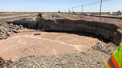
Niland Geyser, Moving mud volcano in Imperial County, United States.

Niland Geyser is a mud volcano in Imperial County that regularly releases hot water, steam, and gases, continuously creating bubbling mud pools and muddy vents. The site is characterized by these active mud sources, which produce an unusual geological display with visible boiling and steam rising from the ground.

This geological formation emerged in 1953 and remained stationary for decades until shifting westward starting in 2007. The movement prompted significant infrastructure adjustments in the surrounding area.

Local engineers and geologists study the geyser's movement patterns to develop protection strategies for nearby transportation routes and communication networks.

Access is restricted because of hazardous gases and unstable ground, so visitors should keep their distance from the active areas. Follow any instructions provided at the site and pay attention to marked boundaries.

This is the only known mud formation worldwide that measurably moves and shifts railways and roads in its path. Its moving nature makes it a remarkable geological occurrence.

The community of curious travelers

AroundUs brings together thousands of curated places, local tips, and hidden gems, enriched daily by 60,000 contributors worldwide.

Start exploring
Location
Inception
1953
GPS coordinates
33.28499,-115.57692
Latest update
December 8, 2025 13:42
Around this place
Salvation Mountain
United States of America

Salvation Mountain

10.3 km
Anza-Borrego Desert State Park
United States of America

Anza-Borrego Desert State Park

76.6 km
Algodones Dunes
United States of America

Algodones Dunes

58.6 km
United States of America

Humana Challenge

74.7 km
United States of America

California State Prison, Centinela

55.1 km
Chuckawalla Valley State Prison
United States of America

Chuckawalla Valley State Prison

69.4 km
Salton Buttes
United States of America

Salton Buttes

10.3 km
Tahquitz Canyon
United States of America

Tahquitz Canyon

72.1 km
Spotlight 29 Casino
United States of America

Spotlight 29 Casino

73.6 km
General George S. Patton Memorial Museum
United States of America

General George S. Patton Memorial Museum

44 km
Sonny Bono Salton Sea National Wildlife Refuge
United States of America

Sonny Bono Salton Sea National Wildlife Refuge

20.9 km
Galleta Meadows Estate
United States of America

Galleta Meadows Estate

74.3 km
Salton Sea State Recreation Area
United States of America

Salton Sea State Recreation Area

35.9 km
North Shore Beach and Yacht Club
United States of America

North Shore Beach and Yacht Club

41.3 km
Mud Caves
United States of America

Mud Caves

69.8 km
Shields Date Gardens
United States of America

Shields Date Gardens

79.4 km
Santa Rosa Wilderness
United States of America

Santa Rosa Wilderness

73.3 km
Fish Creek Mountains Wilderness
United States of America

Fish Creek Mountains Wilderness

53.3 km
Corn Springs
United States of America

Corn Springs

44.6 km
Museo Sol del Niño
Mexico

Museo Sol del Niño

71 km
Calexico Carnegie Library
United States of America

Calexico Carnegie Library

69 km
Martinez Canyon Rockhouse
United States of America

Martinez Canyon Rockhouse

73.8 km
Ruby Lee Mill Site
United States of America

Ruby Lee Mill Site

65.8 km
Jack Nicklaus Resort Golf Course
United States of America

Jack Nicklaus Resort Golf Course

74.6 km
Cottonwood Visitor Center
United States of America

Cottonwood Visitor Center

56.5 km
Punta Este Corporativo

Punta Este Corporativo

72.3 km
Cottonwood Campground Amphitheater
United States of America

Cottonwood Campground Amphitheater

55.6 km
Cottonwood Campground
United States of America

Cottonwood Campground

55.5 km
Show the full map
Reviews
Share your experience

No review yet

Discussions
Start a discussion...

No discussion yet

« Niland Geyser - Moving mud volcano in Imperial County, United States » is provided by Around Us (aroundus.com). Images and texts are derived from Wikimedia project under a Creative Commons license. You are allowed to copy, distribute, and modify copies of this page, under the conditions set by the license, as long as this note is clearly visible.

Discover hidden gems everywhere you go!

From secret cafés to breathtaking viewpoints, skip the crowded tourist spots and find places that match your style. Our app makes it easy with voice search, smart filtering, route optimization, and insider tips from travelers worldwide. Download now for the complete mobile experience.

Around Us App Screenshot

A unique approach to discovering new places

Le Figaro

All the places worth exploring

France Info

A tailor-made excursion in just a few clicks

20 Minutes

Around Us
Travel Guide & Maps
Download

Send to your phone

QR Code
1

Open the camera app on your mobile.

2

Point at the QR code with your camera. A notification will appear.

3

Tap the notification to open the link.