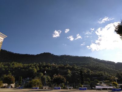
Sierra Madre del Sur pine-oak forests, Subtropical coniferous forest in Sierra Madre del Sur, Mexico.
The Sierra Madre del Sur pine-oak forests stretch across multiple states along Mexico's Pacific coast and form an extensive woodland ecosystem with mixed conifer and oak stands. The terrain is mountainous with varied forest types depending on elevation, ranging from denser vegetation in lower areas to more open stands at higher altitudes.
The forest formation began millions of years ago when tectonic movements created the Sierra Madre del Sur mountain range running parallel to the Pacific coast. This geological history continues to shape the landscape structure and conditions that support the woodland ecosystem today.
Indigenous communities in the region have harvested medicinal plants and managed forests sustainably for generations, practices that remain visible in how the land is used today. This relationship between people and the forest shapes the landscape and reflects deep local knowledge of the ecosystem.
Visitors can explore the forest through established trails in protected areas like Omiltemi State Ecological Park, where guided nature walks are available. Sturdy footwear and preparation for mountainous terrain are important since many paths cross steep or uneven ground.
The forest is home to around 160 bird species, including the short-crested coquette hummingbird found only in a small pocket of this ecosystem. This narrow geographic range makes this tiny bird a rare discovery for those watching birds.
GPS coordinates: 17.55000,-100.30000
Latest update: December 6, 2025 17:44
Guerrero brings together Pacific coastline, colonial towns, and archaeological sites from pre-Hispanic civilizations. The landscape ranges from sandy beaches and offshore islands to cave systems and waterfalls in the mountainous interior of the Sierra Madre del Sur. Taxco displays baroque churches and silver mining heritage, while Acapulco combines modern resort areas with historical fortifications. The region preserves traces of different eras: Tehuacalco and Teopantecuanitlan document indigenous settlements, Santa Prisca Church showcases eighteenth-century colonial architecture, and Fort San Diego recalls the defensive structures of the colonial period. Natural spaces such as Cacahuamilpa Caves, the botanical garden in Acapulco, and remote beaches near Troncones or Barra de Potosí offer contrast to the cultural sites. The cliffs at La Quebrada and the bays around Zihuatanejo rank among the better-known coastal points, while smaller places like Ixcateopan present local history and rural life.
La Quebrada, Mexico
88.4 km
Acapulco Diamante
95.5 km
Fort San Diego
88.7 km
Capilla Ecuménica La Paz
88.4 km
Xochipala
75.4 km
El Veladero National Park
83.5 km
Tehuacalco
93.8 km
Playa Langosta
88.8 km
Fuente de la Diana cazadora (Acapulco)
89.3 km
Playa Tlacopanocha
88.8 km
Chilpancingo Cathedral
84.8 km
Puerto Transatlántico Internacional Teniente José Azueta
88.7 km
Our Lady of Solitude Cathedral, Acapulco
88.4 km
Plaza Álvarez
88.4 km
Oceanic 2000
91.7 km
Crowne Plaza Acapulco
89 km
Fortín Álvarez
87.8 km
Torres Gemelas
90 km
Cañón del Zopilote
84.1 km
Sunset Chapel
93.9 km
Acapulco Botanical Garden
93.7 km
San Francisco
79.6 km
Scenic viewpoint
88.5 km
Museo Interactivo "La Avispa"
85.5 km
La Roqueta Island Lighthouse
91.4 km
Sinfonía del Mar
88.6 km
Playa Pie de La Cuesta
80.5 km
Mirador de la Bahía
88.5 kmReviews
Visited this place? Tap the stars to rate it and share your experience / photos with the community! Try now! You can cancel it anytime.
Discover hidden gems everywhere you go!
From secret cafés to breathtaking viewpoints, skip the crowded tourist spots and find places that match your style. Our app makes it easy with voice search, smart filtering, route optimization, and insider tips from travelers worldwide. Download now for the complete mobile experience.
A unique approach to discovering new places❞
— Le Figaro
All the places worth exploring❞
— France Info
A tailor-made excursion in just a few clicks❞
— 20 Minutes