Chest opened
+${chestReward.xp} XP
Explorer
NOUVEAU ×${chestReward.collectible.quantity}
tapez pour fermer
Chest locked

Open chests in the app

Around Us is built for your phone — chests unlock when you walk, explore and capture nearby places.

Enable Location

We need your location to show you interesting places around you

Discover nearby places

Find interesting locations and hidden gems around you

Precise directions

Get accurate directions and distances to places

Your location is never shared with other users. It's only used when you tap the location button.

Log in to your account

Start exploring — it's free

Trusted by 73,082 travelers worldwide

Continue with Google
Continue with Apple
or

We will send you a code to connect

By continuing, you accept our Terms and Conditions and our Privacy Policy

Check your inbox

We've sent a pincode in your inbox. Please enter the code below.

Woman Hollering Creek
Discussion Reviews Photo
17.3k Popularity

Woman Hollering Creek, Creek in Bexar County, Texas.

Woman Hollering Creek is a waterway in Bexar County that flows between San Antonio and Seguin, crossing Interstate 10 before merging with Martinez Creek. It eventually continues toward the San Antonio River, connecting different areas across south Texas.

Spanish maps from the 1830s recorded this waterway as Arroyo de la Llorona, showing how Spanish colonial names shaped local geography. The creek has retained echoes of this heritage in its identity.

The creek's name inspired Sandra Cisneros to publish a short story collection in 1991, reflecting local Mexican folklore and the voices heard in this region.

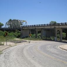
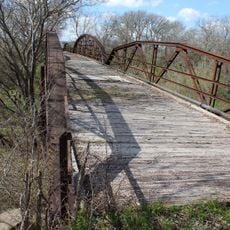
The creek is easy to spot near Interstate 10, where a bridge and road sign mark it clearly at Exit 591 on Farm to Market Road 1518. This location makes it simple to see and access from the highway.

Local folklore connects the name to sounds described as a woman's cries, linking the geography to Mexican legend and cultural memory. This connection between landscape and story makes the spot memorable for those interested in regional traditions.

The community of curious travelers

AroundUs brings together thousands of curated places, local tips, and hidden gems, enriched daily by 60,000 contributors worldwide.

Start exploring
Location
GPS coordinates
29.44800,-98.18880
Latest update
December 7, 2025 19:25
Around this place
Fort Sam Houston
United States of America

Fort Sam Houston

24.4 km
Morgan's Wonderland
United States of America

Morgan's Wonderland

22.1 km
Toyota Field
United States of America

Toyota Field

22.4 km
McNay Art Museum
United States of America

McNay Art Museum

26.3 km
Magnolia Hotel
United States of America

Magnolia Hotel

25.7 km
Calaveras Lake
United States of America

Calaveras Lake

22.2 km
Heroes Stadium
United States of America

Heroes Stadium

22.5 km
San Antonio Botanical Garden
United States of America

San Antonio Botanical Garden

26.2 km
Calaveras Power Station
United States of America

Calaveras Power Station

20.4 km
ZDT's Amusement Park
United States of America

ZDT's Amusement Park

26 km
United States Army Medical Department Museum
United States of America

United States Army Medical Department Museum

24.2 km
Verizon Wireless Amphitheater
United States of America

Verizon Wireless Amphitheater

20.9 km
Morgan's Inspiration Island
United States of America

Morgan's Inspiration Island

22.3 km
Administration Building
United States of America

Administration Building

13.3 km
Los Nogales
United States of America

Los Nogales

25.5 km
Sebastopol House State Historic Site
United States of America

Sebastopol House State Historic Site

24.9 km
Saffold Dam
United States of America

Saffold Dam

24.1 km
Randolph Field Historic District
United States of America

Randolph Field Historic District

12.9 km
Seguin Walnut Springs Park
United States of America

Seguin Walnut Springs Park

25.2 km
Monastery of Our Lady of Charity
United States of America

Monastery of Our Lady of Charity

25.4 km
State Highway 3-A Bridge at Cibolo Creek
United States of America

State Highway 3-A Bridge at Cibolo Creek

5.9 km
Mueller Bridge
United States of America

Mueller Bridge

15.3 km
Robert Hall House
United States of America

Robert Hall House

25.4 km
Palace Theatre
United States of America

Palace Theatre

25.4 km
Texas Theatre
United States of America

Texas Theatre

25.8 km
Brooke Army Medical Center
United States of America

Brooke Army Medical Center

25.3 km
Quadrangle, The
United States of America

Quadrangle, The

26.5 km
Warncke Family Cemetery
United States of America

Warncke Family Cemetery

9.3 km
Show the full map
Reviews
Share your experience

No review yet

Discussions
Start a discussion...

No discussion yet

« Woman Hollering Creek - Creek in Bexar County, Texas » is provided by Around Us (aroundus.com). Images and texts are derived from Wikimedia project under a Creative Commons license. You are allowed to copy, distribute, and modify copies of this page, under the conditions set by the license, as long as this note is clearly visible.

Discover hidden gems everywhere you go!

From secret cafés to breathtaking viewpoints, skip the crowded tourist spots and find places that match your style. Our app makes it easy with voice search, smart filtering, route optimization, and insider tips from travelers worldwide. Download now for the complete mobile experience.

Around Us App Screenshot

A unique approach to discovering new places

Le Figaro

All the places worth exploring

France Info

A tailor-made excursion in just a few clicks

20 Minutes

Around Us
Travel Guide & Maps
Download

Send to your phone

QR Code
1

Open the camera app on your mobile.

2

Point at the QR code with your camera. A notification will appear.

3

Tap the notification to open the link.