Upper Las Virgenes Canyon Open Space Preserve

Log in to your account

AroundUs is a community-driven map of interesting places, built by curious explorers like you. It grows with every review, story, and photo you share.
Connect to save your favorite spots, contribute locations, and create personalized routes.
Continue with Google
Continue with Apple
Continue with X
Continue with Facebook
Continue with email
By continuing, you accept our Terms and Conditions and our Privacy Policy
Create an account

Upper Las Virgenes Canyon Open Space Preserve

Add to collection
Map
Suggest a change
Share

Upper Las Virgenes Canyon Open Space Preserve, Regional park in San Fernando Valley, US

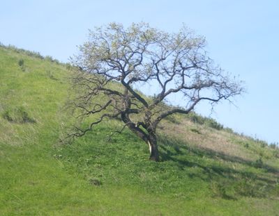
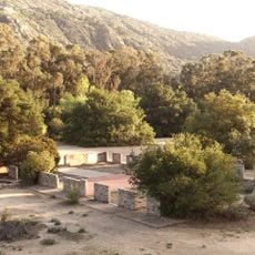
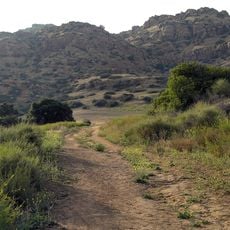
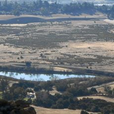
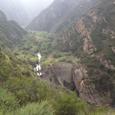
Upper Las Virgenes Canyon Open Space Preserve is a regional park spread across rolling hills dotted with oak trees and canyons lined with sycamores. It sits at the western edge of San Fernando Valley and protects varied natural habitats.

The land was once managed as Ahmanson Ranch before being purchased in 2003 by the Santa Monica Mountains Conservancy to protect it from residential development. This transition turned the property into protected public parkland.

The area was once home to the Chumash, Tongva, and Tataviam peoples, who established a village called Huwam near Bell Creek within these lands. Today, visitors walk through a landscape that held deep meaning for these communities.

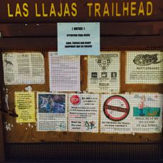
The preserve can be accessed from two main trailheads: Victory Trailhead at Victory Boulevard in West Hills, or Upper Las Virgenes Canyon Trailhead at Las Virgenes Canyon Road in Calabasas. Both entry points provide good starting spots for exploring the area on foot.

The area functions as an ecological corridor connecting the Santa Monica Mountains to ranges further north, serving as refuge for endangered species like the California red-legged frog. This role makes it a critical wildlife haven within an otherwise developed region.

Website: http://ahmanson.org

GPS coordinates: 34.18420,-118.70200

Latest update: December 9, 2025 18:42

Photos
Around this place
Ronald Reagan Presidential Library
United States of America

Ronald Reagan Presidential Library

13.7 km
William Howard Taft Charter High School
United States of America

William Howard Taft Charter High School

12 km
Malibu Creek State Park
United States of America

Malibu Creek State Park

9.3 km
Corriganville Movie Ranch
United States of America

Corriganville Movie Ranch

10.4 km
Leonis Adobe
United States of America

Leonis Adobe

6.4 km
Malibu Hindu Temple
United States of America

Malibu Hindu Temple

9.9 km
Jungleland USA
United States of America

Jungleland USA

13.5 km
Santa Susana Pass State Historic Park
United States of America

Santa Susana Pass State Historic Park

11 km
Topanga State Park
United States of America

Topanga State Park

17.2 km
Grandma Prisbrey's Bottle Village
United States of America

Grandma Prisbrey's Bottle Village

10.6 km
Orcutt Ranch Horticulture Center
United States of America

Orcutt Ranch Horticulture Center

6.8 km
Thousand Oaks Civic Arts Plaza
United States of America

Thousand Oaks Civic Arts Plaza

13.5 km
Chatsworth Nature Preserve
United States of America

Chatsworth Nature Preserve

8.6 km
The Rock Store
United States of America

The Rock Store

11.5 km
Gardens of the World
United States of America

Gardens of the World

13.5 km
Topanga Canyon
United States of America

Topanga Canyon

12.8 km
Shadow Ranch
United States of America

Shadow Ranch

7.6 km
Grant R. Brimhall Library
United States of America

Grant R. Brimhall Library

13.4 km
Mount McCoy
United States of America

Mount McCoy

12.8 km
Minnie Hill Palmer House
United States of America

Minnie Hill Palmer House

11.7 km
Simi Adobe-Strathearn House
United States of America

Simi Adobe-Strathearn House

13.6 km
Las Llajas Canyon
United States of America

Las Llajas Canyon

12.7 km
Castro Peak
United States of America

Castro Peak

13.4 km
Old Trapper's Lodge
United States of America

Old Trapper's Lodge

10.9 km
Colony House
United States of America

Colony House

13.6 km
South Malibu Canyon Road
United States of America

South Malibu Canyon Road

13.4 km
Santa Susana Railroad Depot & Museum
United States of America

Santa Susana Railroad Depot & Museum

9.3 km
Leonis Adobe
United States of America

Leonis Adobe

6.4 km
Show the full map
Reviews

Visited this place? Tap the stars to rate it and share your experience / photos with the community! Try now! You can cancel it anytime.

« Upper Las Virgenes Canyon Open Space Preserve - Regional park in San Fernando Valley, US » is provided by Around Us (aroundus.com). Images and texts are derived from Wikimedia project under a Creative Commons license. You are allowed to copy, distribute, and modify copies of this page, under the conditions set by the license, as long as this note is clearly visible.

Discover hidden gems everywhere you go!

From secret cafés to breathtaking viewpoints, skip the crowded tourist spots and find places that match your style. Our app makes it easy with voice search, smart filtering, route optimization, and insider tips from travelers worldwide. Download now for the complete mobile experience.

Around Us App Screenshot

A unique approach to discovering new places

Le Figaro

All the places worth exploring

France Info

A tailor-made excursion in just a few clicks

20 Minutes