Enable Location

We need your location to show you interesting places around you

Discover nearby places

Find interesting locations and hidden gems around you

Precise directions

Get accurate directions and distances to places

Your location is never shared with other users. It's only used when you tap the location button.

South Serrano Avenue Historic District

Log in to your account

Start exploring — it's free

Trusted by 61,909 travelers worldwide

Continue with Google
Continue with Apple
or

We will send you a code to connect

By continuing, you accept our Terms and Conditions and our Privacy Policy

Check your inbox

We've sent a pincode in your inbox. Please enter the code below.

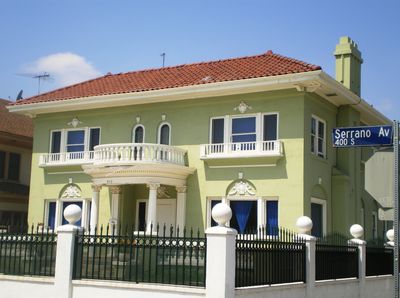
South Serrano Avenue Historic District, Historic residential district in Mid-City, Los Angeles, United States.

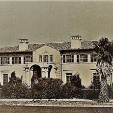
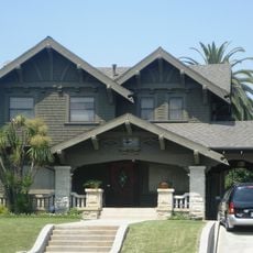
The South Serrano Avenue Historic District is a residential area in central Los Angeles featuring early 20th-century houses along the 400 block between 4th and 5th Streets. The collection comprises 17 buildings constructed between 1912 and 1921 that remain intact today.

The houses were built during a period of rapid residential growth in Los Angeles during the 1910s. The district was added to the National Register of Historic Places in 1988, recognizing its importance as a well-preserved example of the city's early residential culture.

The homes showcase late revival architectural styles shaped by local architects such as Frank Tyler and Harry Whiteley. Residents valued these dwellings as expressions of their prosperity and social standing in the rapidly expanding city.

The district lies in an urban area with limited parking, so visitors should arrive early or use nearby parking options. Since these are private homes, visitors must explore the neighborhood from public streets and respect the privacy of residents.

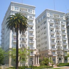
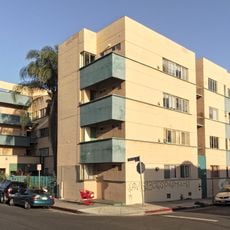
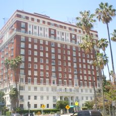
This is one of the few complete blocks of original single-family homes that remains surrounded by modern apartment buildings. This contrasting landscape reveals the dramatic transformation of the area from the 1910s to today.

The community of curious travelers

AroundUs brings together thousands of curated places, local tips, and hidden gems, enriched daily by 60,000 contributors worldwide.

Start exploring
Location
GPS coordinates
34.06639,-118.30556
Latest update
December 14, 2025 13:07
Around this place
Getty House
United States of America

Getty House

1.3 km
Oasis Church
United States of America

Oasis Church

695 m
Pellissier Building and Wiltern Theatre
United States of America

Pellissier Building and Wiltern Theatre

622 m
Bullock’s Wilshire
United States of America

Bullock’s Wilshire

1.7 km
Wilshire Boulevard Temple
United States of America

Wilshire Boulevard Temple

490 m
Rancho La Brea
United States of America

Rancho La Brea

651 m
El Royale
United States of America

El Royale

2.4 km
Ebell of Los Angeles
United States of America

Ebell of Los Angeles

1.8 km
Wilshire Country Club
United States of America

Wilshire Country Club

2.3 km
William O. Jenkins House
United States of America

William O. Jenkins House

1.3 km
Immanuel Presbyterian Church
United States of America

Immanuel Presbyterian Church

1.2 km
Los Altos Apartments
United States of America

Los Altos Apartments

1.1 km
Marciano Art Foundation
United States of America

Marciano Art Foundation

1.7 km
Hayworth Theatre
United States of America

Hayworth Theatre

2.4 km
Bryson Apartment Hotel
United States of America

Bryson Apartment Hotel

2.3 km
Islamic Center of Southern California
United States of America

Islamic Center of Southern California

1.3 km
Equitable Life Building
United States of America

Equitable Life Building

815 m
Jardinette Apartments
United States of America

Jardinette Apartments

2.1 km
The Town House
United States of America

The Town House

2 km
Wilton Historic District
United States of America

Wilton Historic District

869 m
Hollywood Melrose Hotel
United States of America

Hollywood Melrose Hotel

2 km
Scottish Rite Masonic Temple
United States of America

Scottish Rite Masonic Temple

1.7 km
Hotel Chancellor
United States of America

Hotel Chancellor

1.3 km
Petitfils-Boos House
United States of America

Petitfils-Boos House

1.5 km
Felipe De Neve Branch
United States of America

Felipe De Neve Branch

2 km
Pro-Cathedral of Saint Vladimir
United States of America

Pro-Cathedral of Saint Vladimir

2.5 km
Wilshire Branch
United States of America

Wilshire Branch

1.1 km
Saint George Bulgarian Eastern Orthodox Church (Los Angeles)
United States of America

Saint George Bulgarian Eastern Orthodox Church (Los Angeles)

884 m
Show the full map
« South Serrano Avenue Historic District - Historic residential district in Mid-City, Los Angeles, United States » is provided by Around Us (aroundus.com). Images and texts are derived from Wikimedia project under a Creative Commons license. You are allowed to copy, distribute, and modify copies of this page, under the conditions set by the license, as long as this note is clearly visible.

Discover hidden gems everywhere you go!

From secret cafés to breathtaking viewpoints, skip the crowded tourist spots and find places that match your style. Our app makes it easy with voice search, smart filtering, route optimization, and insider tips from travelers worldwide. Download now for the complete mobile experience.

Around Us App Screenshot

A unique approach to discovering new places

Le Figaro

All the places worth exploring

France Info

A tailor-made excursion in just a few clicks

20 Minutes

Around Us
Travel Guide & Maps
Download

Send to your phone

QR Code
1

Open the camera app on your mobile.

2

Point at the QR code with your camera. A notification will appear.

3

Tap the notification to open the link.