Enable Location

We need your location to show you interesting places around you

Discover nearby places

Find interesting locations and hidden gems around you

Precise directions

Get accurate directions and distances to places

Your location is never shared with other users. It's only used when you tap the location button.

St. Johns River Veterans Memorial Bridge

Log in to your account

Start exploring — it's free

Trusted by 62,942 travelers worldwide

Continue with Google
Continue with Apple
or

We will send you a code to connect

By continuing, you accept our Terms and Conditions and our Privacy Policy

Check your inbox

We've sent a pincode in your inbox. Please enter the code below.

St. Johns River Veterans Memorial Bridge
Discussion Reviews 1 Photos
2.6k Popularity

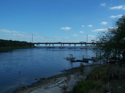
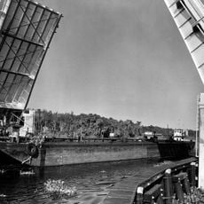
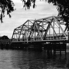
St. Johns River Veterans Memorial Bridge, Road bridge in Sanford, United States.

The St. Johns River Veterans Memorial Bridge extends across the water to link Sanford with DeBary on the opposite side. The structure consists of two separate roadways, each with three lanes and wide shoulders for safe passage.

The structure was completed in 1960 as a four-lane concrete construction to provide a stable link across the water. In the early 2000s, it underwent major renovation to handle increased traffic flow.

The name honors military veterans and serves as a daily connection between two communities across the river. For local people, it is more than just a bridge - it is a vital link that binds the region together.

The bridge is best experienced during daylight when visibility across the water is clearest. Crossing is straightforward, though peak travel times can bring congestion.

The bridge was specifically designed to allow boats and ships to pass underneath, which is especially important in this region of waterways. This clearance keeps the river a living waterway for local boaters and recreational users.

The community of curious travelers

AroundUs brings together thousands of curated places, local tips, and hidden gems, enriched daily by 60,000 contributors worldwide.

Start exploring
Location
Inception
1960
Official opening
1960
GPS coordinates
28.83580,-81.31920
Latest update
December 12, 2025 16:40
Around this place
Majesty Building
United States of America

Majesty Building

19.5 km
The Senator
United States of America

The Senator

13 km
Blue Spring State Park
United States of America

Blue Spring State Park

12.7 km
Central Florida Zoo and Botanical Gardens
United States of America

Central Florida Zoo and Botanical Gardens

937 m
Spec Martin Stadium
United States of America

Spec Martin Stadium

20.6 km
Hontoon Island State Park
United States of America

Hontoon Island State Park

15.2 km
John B. Stetson House
United States of America

John B. Stetson House

20.9 km
DeBary Hall
United States of America

DeBary Hall

4.8 km
Louis P. Thursby House
United States of America

Louis P. Thursby House

12.1 km
Wayne Densch Performing Arts Center
United States of America

Wayne Densch Performing Arts Center

5.8 km
Southern Cassadaga Spiritualist Camp Historic District
United States of America

Southern Cassadaga Spiritualist Camp Historic District

16.4 km
Bradlee-McIntyre House
United States of America

Bradlee-McIntyre House

19.7 km
Francis P. Whitehair Bridge
United States of America

Francis P. Whitehair Bridge

20.2 km
Lake Monroe Bridge
United States of America

Lake Monroe Bridge

494 m
Lake Helen Historic District
United States of America

Lake Helen Historic District

18.9 km
St. James A. M. E. Church
United States of America

St. James A. M. E. Church

6.4 km
Orange City Historic District
United States of America

Orange City Historic District

12.7 km
Ann Stevens House
United States of America

Ann Stevens House

17.1 km
Longwood Historic District
United States of America

Longwood Historic District

15.5 km
Stockton-Lindquist House
United States of America

Stockton-Lindquist House

19.9 km
Orange City Town Hall
United States of America

Orange City Town Hall

12.8 km
Lake Mary Chamber of Commerce Building
United States of America

Lake Mary Chamber of Commerce Building

8.7 km
Hopper Academy
United States of America

Hopper Academy

6.7 km
Seth French House
United States of America

Seth French House

13.2 km
Sanford Residential Historic District
United States of America

Sanford Residential Historic District

6 km
Seminole County Home
United States of America

Seminole County Home

10.5 km
Sanford Commercial District
United States of America

Sanford Commercial District

5.7 km
Wekiwa Springs State Park
United States of America

Wekiwa Springs State Park

19.2 km
Show the full map
Reviews
Share your experience

No review yet

Discussions
Start a discussion...

No discussion yet

« St. Johns River Veterans Memorial Bridge - Road bridge in Sanford, United States » is provided by Around Us (aroundus.com). Images and texts are derived from Wikimedia project under a Creative Commons license. You are allowed to copy, distribute, and modify copies of this page, under the conditions set by the license, as long as this note is clearly visible.

Discover hidden gems everywhere you go!

From secret cafés to breathtaking viewpoints, skip the crowded tourist spots and find places that match your style. Our app makes it easy with voice search, smart filtering, route optimization, and insider tips from travelers worldwide. Download now for the complete mobile experience.

Around Us App Screenshot

A unique approach to discovering new places

Le Figaro

All the places worth exploring

France Info

A tailor-made excursion in just a few clicks

20 Minutes

Around Us
Travel Guide & Maps
Download

Send to your phone

QR Code
1

Open the camera app on your mobile.

2

Point at the QR code with your camera. A notification will appear.

3

Tap the notification to open the link.