Chest opened
+${chestReward.xp} XP
Explorer
NOUVEAU ×${chestReward.collectible.quantity}
tapez pour fermer
Chest locked

Open chests in the app

Around Us is built for your phone — chests unlock when you walk, explore and capture nearby places.

Enable Location

We need your location to show you interesting places around you

Discover nearby places

Find interesting locations and hidden gems around you

Precise directions

Get accurate directions and distances to places

Your location is never shared with other users. It's only used when you tap the location button.

Log in to your account

Start exploring — it's free

Trusted by 72,990 travelers worldwide

Continue with Google
Continue with Apple
or

We will send you a code to connect

By continuing, you accept our Terms and Conditions and our Privacy Policy

Check your inbox

We've sent a pincode in your inbox. Please enter the code below.

McKinley Washington, Jr. Bridge
Discussion Reviews Photo
1.2k Popularity

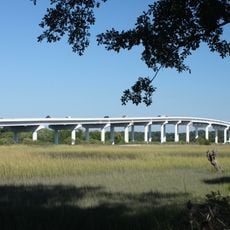
McKinley Washington, Jr. Bridge, Road bridge near Edisto Island, South Carolina, US.

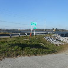
The McKinley Washington Jr. Bridge is a road bridge spanning the Dawhoo River and connecting Edisto Island to the mainland. The structure carries traffic on South Carolina Highway 174 across multiple steel spans.

The current bridge opened in 1993, replacing two earlier structures built in 1920 and 1950. This replacement improved traffic capacity and allowed greater clearance for passing vessels.

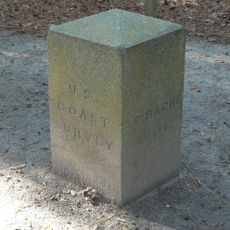
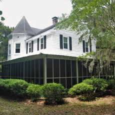
The bridge is named after Reverend McKinley Washington Jr., a community leader who played a significant role in South Carolina politics. His name reflects the importance the region places on his legacy.

The bridge serves as a main connection for daily traffic between the island and the mainland. Access is available year-round, and parking is available on both sides.

The structure features an elevated section that provides sufficient height for ships passing underneath. This design allows both road traffic and maritime passage to coexist without interference.

The community of curious travelers

AroundUs brings together thousands of curated places, local tips, and hidden gems, enriched daily by 60,000 contributors worldwide.

Start exploring
Location
GPS coordinates
32.63720,-80.34030
Latest update
December 14, 2025 18:46
Around this place
United States of America

Charleston Tea Plantation

14.6 km
Botany Bay Plantation Wildlife Management Area
United States of America

Botany Bay Plantation Wildlife Management Area

13.7 km
Edisto Beach State Park
United States of America

Edisto Beach State Park

14.4 km
William Seabrook House
United States of America

William Seabrook House

6.8 km
Hutchinson House
United States of America

Hutchinson House

10.8 km
Brick House Ruins
United States of America

Brick House Ruins

4.2 km
Coffin Point Plantation
United States of America

Coffin Point Plantation

26.1 km
John F. Limehouse Memorial Bridge
United States of America

John F. Limehouse Memorial Bridge

27.3 km
Oak Island
United States of America

Oak Island

9.6 km
Cassina Point
United States of America

Cassina Point

9.8 km
Grove Plantation
United States of America

Grove Plantation

5.9 km
Charleston Tea Garden
United States of America

Charleston Tea Garden

14.7 km
Pon Pon Chapel
United States of America

Pon Pon Chapel

23.8 km
Prospect Hill
United States of America

Prospect Hill

7.4 km
Seaside Plantation House
United States of America

Seaside Plantation House

13.8 km
John's Island Presbyterian Church
United States of America

John's Island Presbyterian Church

24.8 km
Edisto Island Presbyterian Church
United States of America

Edisto Island Presbyterian Church

7.7 km
The Progressive Club
United States of America

The Progressive Club

28.3 km
Summit Plantation House
United States of America

Summit Plantation House

8.1 km
Sunnyside
United States of America

Sunnyside

8.9 km
Edisto Island Baptist Church
United States of America

Edisto Island Baptist Church

8.9 km
Alexander Bache U.S. Coast Survey Line
United States of America

Alexander Bache U.S. Coast Survey Line

14.9 km
Spanish Mount Point
United States of America

Spanish Mount Point

15.5 km
Stono River Slave Rebellion Site
United States of America

Stono River Slave Rebellion Site

24.7 km
Coffin Point Plantation Caretaker's House
United States of America

Coffin Point Plantation Caretaker's House

25.7 km
Trinity Episcopal Church
United States of America

Trinity Episcopal Church

9.2 km
Wilkinson-Boineau House
United States of America

Wilkinson-Boineau House

9.2 km
Seabrook Beach
United States of America

Seabrook Beach

18.6 km
Show the full map
Reviews
Share your experience

No review yet

Discussions
Start a discussion...

No discussion yet

« McKinley Washington, Jr. Bridge - Road bridge near Edisto Island, South Carolina, US » is provided by Around Us (aroundus.com). Images and texts are derived from Wikimedia project under a Creative Commons license. You are allowed to copy, distribute, and modify copies of this page, under the conditions set by the license, as long as this note is clearly visible.

Discover hidden gems everywhere you go!

From secret cafés to breathtaking viewpoints, skip the crowded tourist spots and find places that match your style. Our app makes it easy with voice search, smart filtering, route optimization, and insider tips from travelers worldwide. Download now for the complete mobile experience.

Around Us App Screenshot

A unique approach to discovering new places

Le Figaro

All the places worth exploring

France Info

A tailor-made excursion in just a few clicks

20 Minutes

Around Us
Travel Guide & Maps
Download

Send to your phone

QR Code
1

Open the camera app on your mobile.

2

Point at the QR code with your camera. A notification will appear.

3

Tap the notification to open the link.