Chest opened
+${chestReward.xp} XP
Explorer
NOUVEAU ×${chestReward.collectible.quantity}
tapez pour fermer
Chest locked

Open chests in the app

Around Us is built for your phone — chests unlock when you walk, explore and capture nearby places.

Enable Location

We need your location to show you interesting places around you

Discover nearby places

Find interesting locations and hidden gems around you

Precise directions

Get accurate directions and distances to places

Your location is never shared with other users. It's only used when you tap the location button.

Log in to your account

Start exploring — it's free

Trusted by 72,891 travelers worldwide

Continue with Google
Continue with Apple
or

We will send you a code to connect

By continuing, you accept our Terms and Conditions and our Privacy Policy

Check your inbox

We've sent a pincode in your inbox. Please enter the code below.

Fourteenth Air Force
Discussion Reviews Photo
27.1k Popularity

Fourteenth Air Force, Military air unit in California, United States

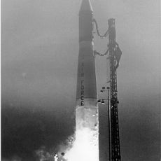
The Fourteenth Air Force is a numbered air unit of the United States Air Force focused on space operations and satellite control. It operates from a base in California and coordinates its activities with the United States Strategic Command.

The unit was established in 1943 under General Claire Chennault and played a major role in combat missions during World War II. After the war, it evolved from air combat duties to modern space operations.

The unit evolved from traditional air combat to space operations, marking a transition in military capabilities and technological advancement.

Visitors can learn about the unit's history and mission through available documentation and public records. Most information is accessible, though some aspects of space operations remain restricted for security reasons.

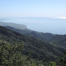
The unit was known for its missions over difficult terrain in Southeast Asia, using narrow mountain passes as flight routes. These geographical challenges led to innovative flying strategies that were later applied in modern air operations.

The community of curious travelers

AroundUs brings together thousands of curated places, local tips, and hidden gems, enriched daily by 60,000 contributors worldwide.

Start exploring
Inception
1943
GPS coordinates
34.73250,-120.56806
Latest update
December 20, 2025 14:09
Around this place
Neverland Ranch
United States of America

Neverland Ranch

43.9 km
Rancho del Cielo
United States of America

Rancho del Cielo

50.4 km
Mission Santa Inés
United States of America

Mission Santa Inés

42.4 km
Guadalupe-Nipomo Dunes
United States of America

Guadalupe-Nipomo Dunes

28.1 km
Gaviota State Park
United States of America

Gaviota State Park

41.1 km
Nojoqui Falls
United States of America

Nojoqui Falls

42.8 km
Pismo State Beach
United States of America

Pismo State Beach

42.4 km
Point Sal State Beach
United States of America

Point Sal State Beach

20.2 km
Point Conception Light
United States of America

Point Conception Light

32.8 km
OstrichLand USA
United States of America

OstrichLand USA

38.5 km
Guadalupe-Nipomo Dunes National Wildlife Refuge
United States of America

Guadalupe-Nipomo Dunes National Wildlife Refuge

30.5 km
Twitchell Reservoir
United States of America

Twitchell Reservoir

36.5 km
Point Arguello Light
United States of America

Point Arguello Light

18.8 km
Pismo Beach
United States of America

Pismo Beach

43.3 km
La Purisima Mission
United States of America

La Purisima Mission

15.1 km
Dana Adobe
United States of America

Dana Adobe

34.1 km
Solvang Vintage Motorcycle Museum
United States of America

Solvang Vintage Motorcycle Museum

42.2 km
Vandenberg Space Force Base Space Launch Complex 10
United States of America

Vandenberg Space Force Base Space Launch Complex 10

6.1 km
Gaviota Peak
United States of America

Gaviota Peak

42.5 km
Los Alamos Ranch House
United States of America

Los Alamos Ranch House

22.6 km
Chapel of San Ramon
United States of America

Chapel of San Ramon

32.5 km
Arroyo Grande IOOF Hall
United States of America

Arroyo Grande IOOF Hall

43.4 km
John Price House
United States of America

John Price House

46.7 km
Elverhøj Museum of History and Art
United States of America

Elverhøj Museum of History and Art

41.9 km
Solvang Park
United States of America

Solvang Park

42.1 km
Espada Bluff
United States of America

Espada Bluff

22.7 km
Solvang Festival Theater
United States of America

Solvang Festival Theater

42 km
Gaviota Beach
United States of America

Gaviota Beach

42.9 km
Show the full map
Reviews
Share your experience

No review yet

Discussions
Start a discussion...

No discussion yet

« Fourteenth Air Force - Military air unit in California, United States » is provided by Around Us (aroundus.com). Images and texts are derived from Wikimedia project under a Creative Commons license. You are allowed to copy, distribute, and modify copies of this page, under the conditions set by the license, as long as this note is clearly visible.

Discover hidden gems everywhere you go!

From secret cafés to breathtaking viewpoints, skip the crowded tourist spots and find places that match your style. Our app makes it easy with voice search, smart filtering, route optimization, and insider tips from travelers worldwide. Download now for the complete mobile experience.

Around Us App Screenshot

A unique approach to discovering new places

Le Figaro

All the places worth exploring

France Info

A tailor-made excursion in just a few clicks

20 Minutes

Around Us
Travel Guide & Maps
Download

Send to your phone

QR Code
1

Open the camera app on your mobile.

2

Point at the QR code with your camera. A notification will appear.

3

Tap the notification to open the link.