Chest opened
+${chestReward.xp} XP
Explorer
NOUVEAU ×${chestReward.collectible.quantity}
tapez pour fermer
Chest locked

Open chests in the app

Around Us is built for your phone — chests unlock when you walk, explore and capture nearby places.

Enable Location

We need your location to show you interesting places around you

Discover nearby places

Find interesting locations and hidden gems around you

Precise directions

Get accurate directions and distances to places

Your location is never shared with other users. It's only used when you tap the location button.

Log in to your account

Start exploring — it's free

Trusted by 72,894 travelers worldwide

Continue with Google
Continue with Apple
or

We will send you a code to connect

By continuing, you accept our Terms and Conditions and our Privacy Policy

Check your inbox

We've sent a pincode in your inbox. Please enter the code below.

Salinian Block
Discussion Reviews Photo
5.8k Popularity

Salinian Block, Geologic terrane west of San Andreas Fault in California, United States

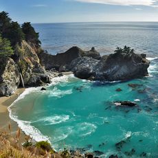
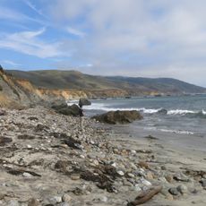
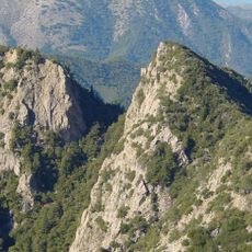
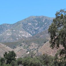
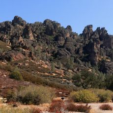
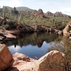
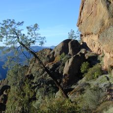
The Salinian Block is a geologic region west of the San Andreas Fault extending from Bodega Head to Mount Pinos, featuring granite and metamorphic rocks throughout. The landscape displays coastal cliffs, forested slopes, and mountainous terrain shaped by this ancient stone foundation.

Roughly 30 million years ago, transform faulting moved massive granite sections northwest to their current position within this region. This tectonic activity created the geological boundary that defines it today.

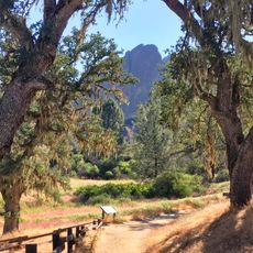
The area supports specialized plants and animals adapted to rocky coastal conditions that visitors can observe in protected zones. These habitats reflect how life has organized itself around the unique geology over time.

The region is accessible through multiple national forests and state parks with established trails at locations like Julia Pfeiffer Burns State Park and the Monterey Peninsula. Visitors should wear sturdy footwear and prepare for steep paths and variable coastal weather.

The granitic core contains rock fragments that originated from batholith systems far to the south and arrived here through ancient tectonic movement. This unusual composition makes it geologically distinct from the surrounding regions.

The community of curious travelers

AroundUs brings together thousands of curated places, local tips, and hidden gems, enriched daily by 60,000 contributors worldwide.

Start exploring
Location
GPS coordinates
36.40500,-121.49200
Latest update
December 10, 2025 16:23
Around this place
WeatherTech Raceway Laguna Seca
United States of America

WeatherTech Raceway Laguna Seca

30.7 km
McWay Falls
United States of America

McWay Falls

31.8 km
Julia Pfeiffer Burns State Park
United States of America

Julia Pfeiffer Burns State Park

30.8 km
Pfeiffer Big Sur State Park
United States of America

Pfeiffer Big Sur State Park

31.4 km
Mission Nuestra Señora de la Soledad
United States of America

Mission Nuestra Señora de la Soledad

12.2 km
Tassajara Zen Mountain Center
United States of America

Tassajara Zen Mountain Center

9.7 km
Tassajara Hot Springs
United States of America

Tassajara Hot Springs

19.8 km
Andrew Molera State Park
United States of America

Andrew Molera State Park

33.4 km
Ventana Wilderness
United States of America

Ventana Wilderness

23.3 km
National Steinbeck Center
United States of America

National Steinbeck Center

33.6 km
Junipero Serra Peak
United States of America

Junipero Serra Peak

29.6 km
Deetjen's Big Sur Inn
United States of America

Deetjen's Big Sur Inn

31.2 km
San Clemente Dam
United States of America

San Clemente Dam

19.7 km
Monterey County Jail
United States of America

Monterey County Jail

33.4 km
Rancho Las Palmas
United States of America

Rancho Las Palmas

28.9 km
Monterey County Court House
United States of America

Monterey County Court House

33.4 km
Krough House
United States of America

Krough House

33.8 km
Pinnacles National Forest
United States of America

Pinnacles National Forest

28.2 km
Sheriff William Joseph Nesbitt House
United States of America

Sheriff William Joseph Nesbitt House

33.8 km
Samuel M. Black House
United States of America

Samuel M. Black House

32.9 km
Monterey Zoo
United States of America

Monterey Zoo

24.2 km
B. V. Sargent House
United States of America

B. V. Sargent House

33.7 km
Berwick Manor and Orchard
United States of America

Berwick Manor and Orchard

31.6 km
Odd Fellows Hall
United States of America

Odd Fellows Hall

12.3 km
Mission Soledad Museum
United States of America

Mission Soledad Museum

12.2 km
Bear Gulch Reservoir
United States of America

Bear Gulch Reservoir

28.1 km
Juniper Canyon Trail
United States of America

Juniper Canyon Trail

27.4 km
Balconies Trail
United States of America

Balconies Trail

27.6 km
Show the full map
Reviews
Share your experience

No review yet

Discussions
Start a discussion...

No discussion yet

« Salinian Block - Geologic terrane west of San Andreas Fault in California, United States » is provided by Around Us (aroundus.com). Images and texts are derived from Wikimedia project under a Creative Commons license. You are allowed to copy, distribute, and modify copies of this page, under the conditions set by the license, as long as this note is clearly visible.

Discover hidden gems everywhere you go!

From secret cafés to breathtaking viewpoints, skip the crowded tourist spots and find places that match your style. Our app makes it easy with voice search, smart filtering, route optimization, and insider tips from travelers worldwide. Download now for the complete mobile experience.

Around Us App Screenshot

A unique approach to discovering new places

Le Figaro

All the places worth exploring

France Info

A tailor-made excursion in just a few clicks

20 Minutes

Around Us
Travel Guide & Maps
Download

Send to your phone

QR Code
1

Open the camera app on your mobile.

2

Point at the QR code with your camera. A notification will appear.

3

Tap the notification to open the link.