Enable Location

We need your location to show you interesting places around you

Discover nearby places

Find interesting locations and hidden gems around you

Precise directions

Get accurate directions and distances to places

Your location is never shared with other users. It's only used when you tap the location button.

Lewiston Lake

Log in to your account

Start exploring — it's free

Trusted by 63,005 travelers worldwide

Continue with Google
Continue with Apple
or

We will send you a code to connect

By continuing, you accept our Terms and Conditions and our Privacy Policy

Check your inbox

We've sent a pincode in your inbox. Please enter the code below.

Lewiston Lake
Discussion Reviews 1 Photos
2.3k Popularity

Lewiston Lake, body of water

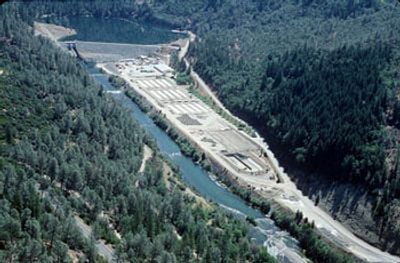
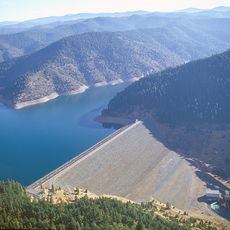
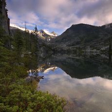
Lewiston Lake is a reservoir in California, held back by a dam on the Trinity River that collects cold, clear water from the surrounding mountains. The lake stretches for several miles with shallow flats and deeper channels where trout congregate throughout the year.

The lake was created in 1963 when a dam was built on the Trinity River to control water flow and generate power. Water enters from Trinity Lake upstream and part of it is diverted through pipes to other waterways in the region.

The lake has a 10 miles per hour speed limit and jet skis are not allowed, though life jackets are required when on the water. A public boat ramp at Pine Cove Marina provides access, and several nearby campgrounds offer facilities like restrooms and picnic areas.

The lake is regularly stocked by California wildlife officials, ensuring a reliable fish population year-round for anglers. Many visitors report catching rainbow trout weighing over 5 pounds, which speaks to the consistency of good catches at this location.

The community of curious travelers

AroundUs brings together thousands of curated places, local tips, and hidden gems, enriched daily by 60,000 contributors worldwide.

Start exploring
Location
GPS coordinates
40.72626,-122.79252
Latest update
February 9, 2026 08:21
Around this place
Shasta Lake
United States of America

Shasta Lake

35.7 km
Sundial Bridge at Turtle Bay
United States of America

Sundial Bridge at Turtle Bay

38.1 km
Castle Crags
United States of America

Castle Crags

62.9 km
Trinity Lake
United States of America

Trinity Lake

11 km
Whiskeytown Lake
United States of America

Whiskeytown Lake

25.5 km
Lake Shasta Caverns
United States of America

Lake Shasta Caverns

42.1 km
Trinity Alps Wilderness
United States of America

Trinity Alps Wilderness

40.7 km
Saint Herman of Alaska Brotherhood
United States of America

Saint Herman of Alaska Brotherhood

43.2 km
Russian Wilderness
United States of America

Russian Wilderness

66 km
Pit River Bridge
United States of America

Pit River Bridge

40.1 km
Turtle Bay Exploration Park
United States of America

Turtle Bay Exploration Park

38.4 km
Castle Crags Wilderness
United States of America

Castle Crags Wilderness

62.5 km
Keswick Dam
United States of America

Keswick Dam

31.9 km
Thompson Peak
United States of America

Thompson Peak

37.4 km
North Yolla Bolly Mountain
United States of America

North Yolla Bolly Mountain

61 km
Russian Peak
United States of America

Russian Peak

63.4 km
Castle Crags State Park
United States of America

Castle Crags State Park

61.9 km
Spring Creek Reservoir
United States of America

Spring Creek Reservoir

29 km
McConnell Arboretum & Botanical Gardens
United States of America

McConnell Arboretum & Botanical Gardens

37.7 km
Cottonwood Historic District
United States of America

Cottonwood Historic District

57.8 km
Bowerman Barn
United States of America

Bowerman Barn

19.5 km
Edward Frisbie House
United States of America

Edward Frisbie House

37.5 km
French Gulch Historic District
United States of America

French Gulch Historic District

13.2 km
Weaverville Joss House State Historic Park
United States of America

Weaverville Joss House State Historic Park

12.5 km
Reading Adobe Site
United States of America

Reading Adobe Site

62.5 km
Lower Pollard Flat Bridge
United States of America

Lower Pollard Flat Bridge

43.4 km
Diestelhorst Bridge
United States of America

Diestelhorst Bridge

36.2 km
UP Sacramento River Bridge
United States of America

UP Sacramento River Bridge

54.4 km
Show the full map
Reviews
Share your experience

No review yet

Discussions
Start a discussion...

No discussion yet

« Lewiston Lake - body of water » is provided by Around Us (aroundus.com). Images and texts are derived from Wikimedia project under a Creative Commons license. You are allowed to copy, distribute, and modify copies of this page, under the conditions set by the license, as long as this note is clearly visible.

Discover hidden gems everywhere you go!

From secret cafés to breathtaking viewpoints, skip the crowded tourist spots and find places that match your style. Our app makes it easy with voice search, smart filtering, route optimization, and insider tips from travelers worldwide. Download now for the complete mobile experience.

Around Us App Screenshot

A unique approach to discovering new places

Le Figaro

All the places worth exploring

France Info

A tailor-made excursion in just a few clicks

20 Minutes

Around Us
Travel Guide & Maps
Download

Send to your phone

QR Code
1

Open the camera app on your mobile.

2

Point at the QR code with your camera. A notification will appear.

3

Tap the notification to open the link.