Chest opened
+${chestReward.xp} XP
Explorer
NOUVEAU ×${chestReward.collectible.quantity}
tapez pour fermer
Chest locked

Open chests in the app

Around Us is built for your phone — chests unlock when you walk, explore and capture nearby places.

Enable Location

We need your location to show you interesting places around you

Discover nearby places

Find interesting locations and hidden gems around you

Precise directions

Get accurate directions and distances to places

Your location is never shared with other users. It's only used when you tap the location button.

Phantom Ship

Log in to your account

Start exploring — it's free

Trusted by 72,892 travelers worldwide

Continue with Google
Continue with Apple
or

We will send you a code to connect

By continuing, you accept our Terms and Conditions and our Privacy Policy

Check your inbox

We've sent a pincode in your inbox. Please enter the code below.

Discussion Reviews 1 Photos
19.2k Popularity

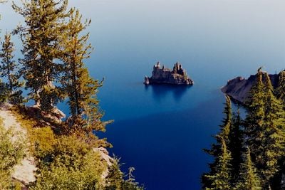
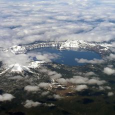
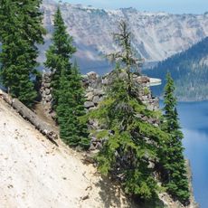
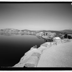
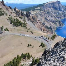
Phantom Ship, Volcanic island in Crater Lake, Oregon

Phantom Ship is a volcanic island that rises about 170 feet (52 m) above Crater Lake's surface with jagged rock formations resembling ship masts and sails. The island sits roughly 300 feet (91 m) from the eastern shore and remains visible from several viewing areas along the rim.

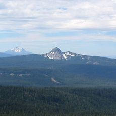
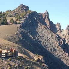
This rock formation emerged roughly 400,000 years ago as part of Mount Mazama's volcanic system, long before the mountain collapsed to create the lake. The island therefore represents one of the oldest exposed features in the basin today.

Local tribes incorporated this rock formation into their oral traditions and spiritual beliefs about the lake. The connection between the place and indigenous stories remains visible in how the landscape shapes regional identity.

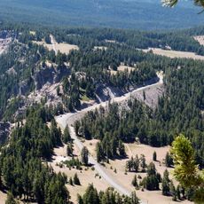
The Phantom Ship Overlook and points along East Rim Drive offer the clearest views of the island. Visit during clear weather for the best visibility, and explore the rim trails to discover different viewing angles from around the lake.

The island contains some of the oldest exposed rock formations in the Crater Lake basin, featuring dark andesite altered by hydrothermal activity. This ancient composition makes it a window into the region's early volcanic history.

The community of curious travelers

AroundUs brings together thousands of curated places, local tips, and hidden gems, enriched daily by 60,000 contributors worldwide.

Start exploring
Location
Width
61 m
GPS coordinates
42.91120,-122.09200
Latest update
December 7, 2025 10:07
Around this place
Old Man of the Lake
United States of America

Old Man of the Lake

4.4 km
Mount Mazama
United States of America

Mount Mazama

3.1 km
Mount Thielsen
United States of America

Mount Thielsen

27 km
Crater Lake Lodge
United States of America

Crater Lake Lodge

4 km
Mount Scott
United States of America

Mount Scott

6.3 km
Rim Drive
United States of America

Rim Drive

4.7 km
Fort Klamath
United States of America

Fort Klamath

26.3 km
Rim Village Historic District
United States of America

Rim Village Historic District

4.2 km
Sun Pass State Forest
United States of America

Sun Pass State Forest

26.3 km
Jackson F. Kimball State Recreation Site
United States of America

Jackson F. Kimball State Recreation Site

21.3 km
Watchman Lookout Station
United States of America

Watchman Lookout Station

7.4 km
Union Peak
United States of America

Union Peak

13.9 km
Sinnott Memorial Observation Station
United States of America

Sinnott Memorial Observation Station

4.2 km
Comfort Station No. 72
United States of America

Comfort Station No. 72

4.5 km
Crater Lake Superintendent's Residence
United States of America

Crater Lake Superintendent's Residence

3.9 km
Comfort Station No. 68
United States of America

Comfort Station No. 68

4.4 km
Munson Valley Historic District
United States of America

Munson Valley Historic District

3.8 km
Plaikni Falls
United States of America

Plaikni Falls

3.5 km
Lathrop Glacier
United States of America

Lathrop Glacier

27.1 km
Rim Drive Historic District
United States of America

Rim Drive Historic District

7.5 km
Castle Crest Wildflower Trail
United States of America

Castle Crest Wildflower Trail

3.8 km
Administration Building
United States of America

Administration Building

3.7 km
Rim Visitor Center
United States of America

Rim Visitor Center

4.2 km
Watchman Peak Trail
United States of America

Watchman Peak Trail

7.5 km
Steel Visitor Center
United States of America

Steel Visitor Center

3.8 km
Mount Scott Trail
United States of America

Mount Scott Trail

5.6 km
Watchman Overlook
United States of America

Watchman Overlook

7.3 km
Devil's Backbone Viewpoint
United States of America

Devil's Backbone Viewpoint

7.7 km
Show the full map
Reviews
Share your experience

No review yet

Discussions
Start a discussion...

No discussion yet

« Phantom Ship - Volcanic island in Crater Lake, Oregon » is provided by Around Us (aroundus.com). Images and texts are derived from Wikimedia project under a Creative Commons license. You are allowed to copy, distribute, and modify copies of this page, under the conditions set by the license, as long as this note is clearly visible.

Discover hidden gems everywhere you go!

From secret cafés to breathtaking viewpoints, skip the crowded tourist spots and find places that match your style. Our app makes it easy with voice search, smart filtering, route optimization, and insider tips from travelers worldwide. Download now for the complete mobile experience.

Around Us App Screenshot

A unique approach to discovering new places

Le Figaro

All the places worth exploring

France Info

A tailor-made excursion in just a few clicks

20 Minutes

Around Us
Travel Guide & Maps
Download

Send to your phone

QR Code
1

Open the camera app on your mobile.

2

Point at the QR code with your camera. A notification will appear.

3

Tap the notification to open the link.