Enable Location

We need your location to show you interesting places around you

Discover nearby places

Find interesting locations and hidden gems around you

Precise directions

Get accurate directions and distances to places

Your location is never shared with other users. It's only used when you tap the location button.

Mount Bailey

Log in to your account

Start exploring — it's free

Trusted by 64,530 travelers worldwide

Continue with Google
Continue with Apple
or

We will send you a code to connect

By continuing, you accept our Terms and Conditions and our Privacy Policy

Check your inbox

We've sent a pincode in your inbox. Please enter the code below.

Mount Bailey
Discussion Reviews 1 Photos
5.7k Popularity

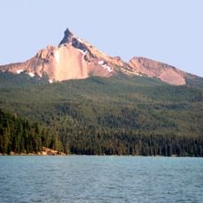
Mount Bailey, Volcanic summit in Douglas County, Oregon, US

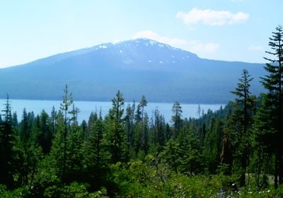
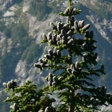
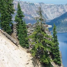
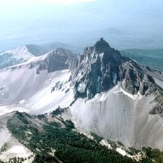
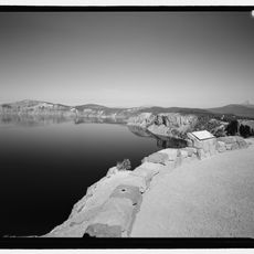
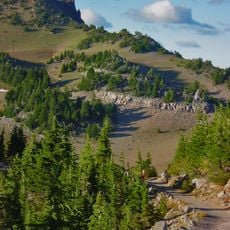
Mount Bailey is a volcanic summit in Douglas County, Oregon, located near Diamond Lake, with slopes covered in mountain hemlock, western white pine, and Shasta fir. Above the treeline the terrain opens up into bare andesite rock, and the highest point holds a snow-filled crater.

The summit was originally known as Mount Baldy, a name that described its bare, treeless top. A cartographer misread a surveyor's handwritten notes and recorded it as Bailey instead, and that mistake has stayed on maps ever since.

The mountain carries the name Youxlokes in the Klamath language, and the Klamath people gathered here for ceremonies long before European settlers arrived. Visitors who reach the summit today are standing on ground that has held meaning for generations of people in this region.

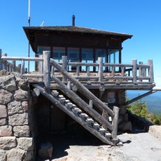
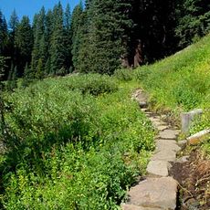
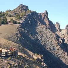
The summit is reached by a hiking trail that starts from the Fox Spring trailhead near Oregon Route 230 and passes through forested terrain before opening onto the upper slopes. Winter conditions can be demanding, so visitors should check the weather carefully and come prepared before setting out.

In winter, snowcat vehicles carry skiers up to the summit, making this one of the few places in North America where you can ski from a volcanic peak without a chairlift. The snowcat service opens up terrain that most mountain resorts simply cannot reach.

The community of curious travelers

AroundUs brings together thousands of curated places, local tips, and hidden gems, enriched daily by 60,000 contributors worldwide.

Start exploring
Location
Elevation above the sea
2,553 m
Made from material
andesite
GPS coordinates
43.15510,-122.22001
Latest update
March 3, 2026 08:16
Around this place
Old Man of the Lake
United States of America

Old Man of the Lake

24.8 km
Mount Mazama
United States of America

Mount Mazama

26 km
Mount Thielsen
United States of America

Mount Thielsen

12.5 km
Toketee Falls
United States of America

Toketee Falls

21 km
Crater Lake Lodge
United States of America

Crater Lake Lodge

28.1 km
Rim Village Historic District
United States of America

Rim Village Historic District

28 km
Watson Falls
United States of America

Watson Falls

16.8 km
Mount Thielsen Wilderness
United States of America

Mount Thielsen Wilderness

17.9 km
Watchman Lookout Station
United States of America

Watchman Lookout Station

23.9 km
Rogue–Umpqua Divide Wilderness
United States of America

Rogue–Umpqua Divide Wilderness

22.1 km
Sinnott Memorial Observation Station
United States of America

Sinnott Memorial Observation Station

27.8 km
Comfort Station No. 72
United States of America

Comfort Station No. 72

27.8 km
Crater Lake Superintendent's Residence
United States of America

Crater Lake Superintendent's Residence

29.2 km
Comfort Station No. 68
United States of America

Comfort Station No. 68

27.8 km
Munson Valley Historic District
United States of America

Munson Valley Historic District

29.5 km
Plaikni Falls
United States of America

Plaikni Falls

30.7 km
Lathrop Glacier
United States of America

Lathrop Glacier

12.4 km
Hershberger Mountain Lookout
United States of America

Hershberger Mountain Lookout

23.4 km
Rim Drive Historic District
United States of America

Rim Drive Historic District

23.9 km
Castle Crest Wildflower Trail
United States of America

Castle Crest Wildflower Trail

29.7 km
Administration Building
United States of America

Administration Building

29.6 km
Rim Visitor Center
United States of America

Rim Visitor Center

27.9 km
Watchman Peak Trail
United States of America

Watchman Peak Trail

23.9 km
Steel Visitor Center
United States of America

Steel Visitor Center

29.6 km
Watchman Overlook
United States of America

Watchman Overlook

23.7 km
Devil's Backbone Viewpoint
United States of America

Devil's Backbone Viewpoint

22.1 km
Discovery Point
United States of America

Discovery Point

26.5 km
Mess Hall
United States of America

Mess Hall

29.6 km
Show the full map
Reviews
Share your experience

No review yet

Discussions
Start a discussion...

No discussion yet

« Mount Bailey - Volcanic summit in Douglas County, Oregon, US » is provided by Around Us (aroundus.com). Images and texts are derived from Wikimedia project under a Creative Commons license. You are allowed to copy, distribute, and modify copies of this page, under the conditions set by the license, as long as this note is clearly visible.

Discover hidden gems everywhere you go!

From secret cafés to breathtaking viewpoints, skip the crowded tourist spots and find places that match your style. Our app makes it easy with voice search, smart filtering, route optimization, and insider tips from travelers worldwide. Download now for the complete mobile experience.

Around Us App Screenshot

A unique approach to discovering new places

Le Figaro

All the places worth exploring

France Info

A tailor-made excursion in just a few clicks

20 Minutes

Around Us
Travel Guide & Maps
Download

Send to your phone

QR Code
1

Open the camera app on your mobile.

2

Point at the QR code with your camera. A notification will appear.

3

Tap the notification to open the link.