Watson Falls

Log in to your account

AroundUs is a community-driven map of interesting places, built by curious explorers like you. It grows with every review, story, and photo you share.
Connect to save your favorite spots, contribute locations, and create personalized routes.
Continue with Google
Continue with Apple
Continue with X
Continue with Facebook
Continue with email
By continuing, you accept our Terms and Conditions and our Privacy Policy
Create an account
Add to collection
Map
Suggest a change
Share

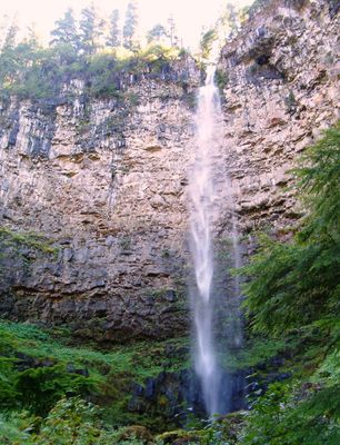
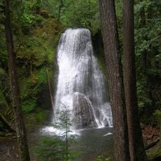
Watson Falls, Waterfall in Umpqua National Forest, Oregon.

Watson Falls is a waterfall in Umpqua National Forest where water drops roughly 90 meters straight down a black basalt cliff face, creating a white curtain of water. The water flows over several tiers and hits rocks at the cliff base before continuing into a stream below.

The waterfall takes its name from an early settler family who established their homestead near the North Umpqua River in the 1800s. The family settled in this region, which later became protected forest land.

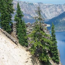
The falls draw visitors interested in geology and natural processes, offering chances to experience how water shapes volcanic landscapes over time. People visit to witness the power of flowing water against the dark stone formations that define this part of Oregon.

A maintained hiking trail of about 1.6 kilometers round trip leads visitors through forest with multiple viewing platforms near the waterfall base. The path is relatively flat and offers several spots to stop and look around.

During winter months, water flowing from the falls partially freezes and creates natural ice formations extending from cliff to ground. These frozen structures give the location a different appearance and attract visitors wanting to see the seasonal transformation.

Location: Oregon

Part of: Clearwater River

GPS coordinates: 43.24151,-122.39004

Latest update: December 11, 2025 18:01

Photos
Around this place
Old Man of the Lake
United States of America

Old Man of the Lake

40.1 km
Mount Mazama
United States of America

Mount Mazama

41 km
Mount Thielsen
United States of America

Mount Thielsen

28 km
Toketee Falls
United States of America

Toketee Falls

4.2 km
Crater Lake Lodge
United States of America

Crater Lake Lodge

42.1 km
Diamond Peak
United States of America

Diamond Peak

36.7 km
Mount Bailey
United States of America

Mount Bailey

16.8 km
Rim Village Historic District
United States of America

Rim Village Historic District

42 km
Mount Thielsen Wilderness
United States of America

Mount Thielsen Wilderness

30.8 km
Diamond Peak Wilderness
United States of America

Diamond Peak Wilderness

36.3 km
Boulder Creek Wilderness
United States of America

Boulder Creek Wilderness

15.9 km
Watchman Lookout Station
United States of America

Watchman Lookout Station

37.7 km
Rogue–Umpqua Divide Wilderness
United States of America

Rogue–Umpqua Divide Wilderness

20.4 km
Sinnott Memorial Observation Station
United States of America

Sinnott Memorial Observation Station

41.9 km
Comfort Station No. 72
United States of America

Comfort Station No. 72

41.7 km
Comfort Station No. 68
United States of America

Comfort Station No. 68

41.8 km
Yakso Falls
United States of America

Yakso Falls

26.5 km
Lathrop Glacier
United States of America

Lathrop Glacier

28 km
Union Creek Historic District
United States of America

Union Creek Historic District

37.5 km
Hershberger Mountain Lookout
United States of America

Hershberger Mountain Lookout

23.7 km
Whaleback Snow-Survey Cabin
United States of America

Whaleback Snow-Survey Cabin

39.9 km
Mott Bridge
United States of America

Mott Bridge

30.1 km
Rim Drive Historic District
United States of America

Rim Drive Historic District

37.6 km
Rim Visitor Center
United States of America

Rim Visitor Center

41.9 km
Watchman Peak Trail
United States of America

Watchman Peak Trail

37.6 km
Watchman Overlook
United States of America

Watchman Overlook

37.5 km
Devil's Backbone Viewpoint
United States of America

Devil's Backbone Viewpoint

36.5 km
Discovery Point
United States of America

Discovery Point

40.3 km
Show the full map
Reviews

Visited this place? Tap the stars to rate it and share your experience / photos with the community! Try now! You can cancel it anytime.

« Watson Falls - Waterfall in Umpqua National Forest, Oregon » is provided by Around Us (aroundus.com). Images and texts are derived from Wikimedia project under a Creative Commons license. You are allowed to copy, distribute, and modify copies of this page, under the conditions set by the license, as long as this note is clearly visible.

Discover hidden gems everywhere you go!

From secret cafés to breathtaking viewpoints, skip the crowded tourist spots and find places that match your style. Our app makes it easy with voice search, smart filtering, route optimization, and insider tips from travelers worldwide. Download now for the complete mobile experience.

Around Us App Screenshot

A unique approach to discovering new places

Le Figaro

All the places worth exploring

France Info

A tailor-made excursion in just a few clicks

20 Minutes