Enable Location

We need your location to show you interesting places around you

Discover nearby places

Find interesting locations and hidden gems around you

Precise directions

Get accurate directions and distances to places

Your location is never shared with other users. It's only used when you tap the location button.

Log in to your account

Start exploring — it's free

Trusted by 62,607 travelers worldwide

Continue with Google
Continue with Apple
or

We will send you a code to connect

By continuing, you accept our Terms and Conditions and our Privacy Policy

Check your inbox

We've sent a pincode in your inbox. Please enter the code below.

Lake Celilo

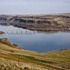
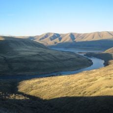
Lake Celilo, body of water

Lake Celilo is a large reservoir on the Columbia River that was formed in 1957 when the Dalles Dam was built. The water stretches about 24 miles long and flows across the border between Oregon and Washington, creating a calm, wide surface that extends across the surrounding landscape.

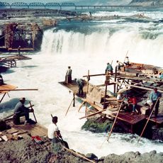
The reservoir was created in 1957 when the Dalles Dam was built, flooding the area that had been home to the famous Celilo Falls. These falls had been a fishing and trading site for over 11,000 years for multiple Native American tribes before the rapid flooding submerged this cultural site.

The site was a meeting place for Native American tribes for thousands of years, where they gathered to fish for salmon and trade goods. These traditions remain alive today, as local communities continue to fish using traditional methods and honor the history of their ancestors in this place.

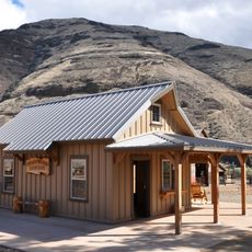
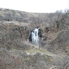
The lake offers places for fishing, boating, and walking along the shores. The area is quiet with open landscapes and few large buildings nearby, so visitors should be prepared for changing weather conditions and take advantage of local facilities such as picnic spots and boat ramps.

When the Dalles Dam began filling in 1957, Celilo Falls disappeared under rising water in less than five hours. This rapid end to a place that had been a center of life for over 11,000 years left deep emotional marks on many tribal members that persist to this day.

The community of curious travelers

AroundUs brings together thousands of curated places, local tips, and hidden gems, enriched daily by 60,000 contributors worldwide.

Start exploring
Location
GPS coordinates
45.72631,-120.69439
Latest update
February 9, 2026 08:20
Around this place
Maryhill Stonehenge
United States of America

Maryhill Stonehenge

9.4 km
Celilo Falls
United States of America

Celilo Falls

23.7 km
John Day Dam
United States of America

John Day Dam

1.1 km
Pacific DC Intertie
United States of America

Pacific DC Intertie

35.8 km
The Dalles Dam
United States of America

The Dalles Dam

36.4 km
Maryhill Museum of Art
United States of America

Maryhill Museum of Art

14.3 km
Goldendale Observatory State Park
United States of America

Goldendale Observatory State Park

15.6 km
Cottonwood Canyon State Park
United States of America

Cottonwood Canyon State Park

32.6 km
Celilo Converter Station
United States of America

Celilo Converter Station

35.8 km
Sam Hill Memorial Bridge
United States of America

Sam Hill Memorial Bridge

12.4 km
The Dalles Bridge
United States of America

The Dalles Bridge

36.9 km
The Dalles Mint
United States of America

The Dalles Mint

40.2 km
Maryhill State Park
United States of America

Maryhill State Park

11.4 km
Deschutes River State Recreation Area
United States of America

Deschutes River State Recreation Area

19.7 km
Oregon Trunk Rail Bridge
United States of America

Oregon Trunk Rail Bridge

24 km
Columbia Hills Historical State Park
United States of America

Columbia Hills Historical State Park

31.7 km
Charles E. Nelson House
United States of America

Charles E. Nelson House

32.9 km
Columbia Hills
United States of America

Columbia Hills

7.3 km
Granada Theater
United States of America

Granada Theater

40.4 km
Goldendale Free Public Library
United States of America

Goldendale Free Public Library

14.5 km
John and Helen Moore House
United States of America

John and Helen Moore House

31.6 km
Indian Shaker Church and Gulick Homestead
United States of America

Indian Shaker Church and Gulick Homestead

36.7 km
The Dalles Civic Auditorium
United States of America

The Dalles Civic Auditorium

40.5 km
First Day Advent Christian Church
United States of America

First Day Advent Christian Church

10.2 km
The Dalles Carnegie Library
United States of America

The Dalles Carnegie Library

40.5 km
Joseph D. and Margaret Kelly House
United States of America

Joseph D. and Margaret Kelly House

40.3 km
Sharp Family Residential Ensemble
United States of America

Sharp Family Residential Ensemble

40.4 km
Sherman County Courthouse
United States of America

Sherman County Courthouse

35.7 km
Show the full map
« Lake Celilo - body of water » is provided by Around Us (aroundus.com). Images and texts are derived from Wikimedia project under a Creative Commons license. You are allowed to copy, distribute, and modify copies of this page, under the conditions set by the license, as long as this note is clearly visible.

Discover hidden gems everywhere you go!

From secret cafés to breathtaking viewpoints, skip the crowded tourist spots and find places that match your style. Our app makes it easy with voice search, smart filtering, route optimization, and insider tips from travelers worldwide. Download now for the complete mobile experience.

Around Us App Screenshot

A unique approach to discovering new places

Le Figaro

All the places worth exploring

France Info

A tailor-made excursion in just a few clicks

20 Minutes

Around Us
Travel Guide & Maps
Download

Send to your phone

QR Code
1

Open the camera app on your mobile.

2

Point at the QR code with your camera. A notification will appear.

3

Tap the notification to open the link.