Chest opened
+${chestReward.xp} XP
Explorer
NOUVEAU ×${chestReward.collectible.quantity}
tapez pour fermer
Chest locked

Open chests in the app

Around Us is built for your phone — chests unlock when you walk, explore and capture nearby places.

Enable Location

We need your location to show you interesting places around you

Discover nearby places

Find interesting locations and hidden gems around you

Precise directions

Get accurate directions and distances to places

Your location is never shared with other users. It's only used when you tap the location button.

Montezuma Well

Log in to your account

Start exploring — it's free

Trusted by 72,878 travelers worldwide

Continue with Google
Continue with Apple
or

We will send you a code to connect

By continuing, you accept our Terms and Conditions and our Privacy Policy

Check your inbox

We've sent a pincode in your inbox. Please enter the code below.

Montezuma Well
Discussion Reviews 1 Photos
25.2k Popularity

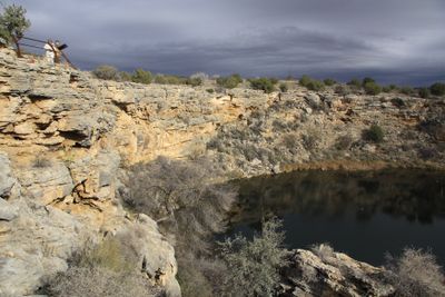
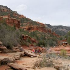
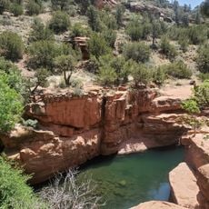
Montezuma Well, Natural limestone sinkhole at Verde Valley, United States.

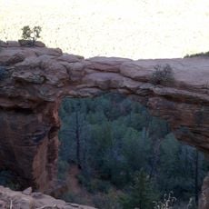
Montezuma Well is a circular limestone sinkhole surrounded by steep walls that contain ancient dwelling sites and traces of irrigation systems. The hole fills with water from an underground spring that produces a continuous flow used for centuries by the people who lived here.

People first used this water source over ten thousand years ago when they began settling in the valley. Over time, the communities built more elaborate settlements and irrigation systems that transformed it into a major center of habitation.

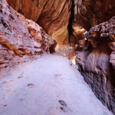
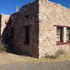
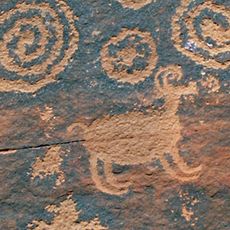
The Sinagua people shaped this area by building settlements and irrigation networks that relied on the constant water source. Walking around the rim, you can still see how they integrated their dwellings and farming systems into the landscape.

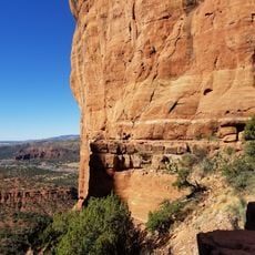
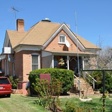
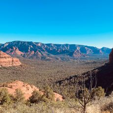
Visit during daylight hours to safely explore the trails and viewpoints around the sinkhole's rim. The paths are marked and relatively accessible, though walking around the natural formation requires some physical comfort on uneven terrain.

The water contains high levels of dissolved carbon dioxide that prevent fish from surviving, yet it hosts several species found nowhere else. This unusual chemistry has created an ecosystem unlike any other place on Earth.

The community of curious travelers

AroundUs brings together thousands of curated places, local tips, and hidden gems, enriched daily by 60,000 contributors worldwide.

Start exploring
Location
GPS coordinates
34.64910,-111.75200
Latest update
December 20, 2025 11:34
Around this place
Chapel of the Holy Cross
United States of America

Chapel of the Holy Cross

20.4 km
Oak Creek Canyon
United States of America

Oak Creek Canyon

29.4 km
Cathedral Rock
United States of America

Cathedral Rock

19.4 km
Slide Rock State Park
United States of America

Slide Rock State Park

29.7 km
Red Rock State Park
United States of America

Red Rock State Park

19.7 km
Bell Rock
United States of America

Bell Rock

16.9 km
Dead Horse Ranch State Park
United States of America

Dead Horse Ranch State Park

26.4 km
Out of Africa Wildlife Park
United States of America

Out of Africa Wildlife Park

16.3 km
Fort Verde State Historic Park
United States of America

Fort Verde State Historic Park

13.1 km
Courthouse Butte
United States of America

Courthouse Butte

17 km
V-Bar-V Heritage Site
United States of America

V-Bar-V Heritage Site

3.3 km
Fossil Springs Wilderness
United States of America

Fossil Springs Wilderness

29.4 km
Cathedral Rock Trailhead
United States of America

Cathedral Rock Trailhead

19.9 km
Soldier Pass Trailhead (Southernmost)
United States of America

Soldier Pass Trailhead (Southernmost)

26.3 km
Fossil Creek Bridge
United States of America

Fossil Creek Bridge

30.5 km
Beaver Creek Ranger Station
United States of America

Beaver Creek Ranger Station

4.6 km
Clear Creek Church
United States of America

Clear Creek Church

15.5 km
Sedona Ranger Station
United States of America

Sedona Ranger Station

23.8 km
Master Mechanic's House
United States of America

Master Mechanic's House

26.8 km
Willard House
United States of America

Willard House

27.7 km
Sedona Heritage Museum
United States of America

Sedona Heritage Museum

25.5 km
Bell Trail
United States of America

Bell Trail

4.5 km
Tuzigoot Museum
United States of America

Tuzigoot Museum

28.5 km
Devil's Bridge, Sedona
United States of America

Devil's Bridge, Sedona

28.2 km
Verde Valley Archaeology Center and Museum
United States of America

Verde Valley Archaeology Center and Museum

13.7 km
Brins Mesa Trailhead
United States of America

Brins Mesa Trailhead

26.7 km
Wilson Mountain Trailhead
United States of America

Wilson Mountain Trailhead

26.4 km
Midgley Bridge
United States of America

Midgley Bridge

26.3 km
Show the full map
Reviews
Share your experience

No review yet

Discussions
Start a discussion...

No discussion yet

« Montezuma Well - Natural limestone sinkhole at Verde Valley, United States » is provided by Around Us (aroundus.com). Images and texts are derived from Wikimedia project under a Creative Commons license. You are allowed to copy, distribute, and modify copies of this page, under the conditions set by the license, as long as this note is clearly visible.

Discover hidden gems everywhere you go!

From secret cafés to breathtaking viewpoints, skip the crowded tourist spots and find places that match your style. Our app makes it easy with voice search, smart filtering, route optimization, and insider tips from travelers worldwide. Download now for the complete mobile experience.

Around Us App Screenshot

A unique approach to discovering new places

Le Figaro

All the places worth exploring

France Info

A tailor-made excursion in just a few clicks

20 Minutes

Around Us
Travel Guide & Maps
Download

Send to your phone

QR Code
1

Open the camera app on your mobile.

2

Point at the QR code with your camera. A notification will appear.

3

Tap the notification to open the link.