Enable Location

We need your location to show you interesting places around you

Discover nearby places

Find interesting locations and hidden gems around you

Precise directions

Get accurate directions and distances to places

Your location is never shared with other users. It's only used when you tap the location button.

Hurricane-LaVerkin Bridge

Log in to your account

Start exploring — it's free

Trusted by 61,991 travelers worldwide

Continue with Google
Continue with Apple
or

We will send you a code to connect

By continuing, you accept our Terms and Conditions and our Privacy Policy

Check your inbox

We've sent a pincode in your inbox. Please enter the code below.

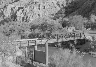
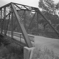
Hurricane-LaVerkin Bridge, Steel truss bridge in Washington County, United States

The Hurricane-LaVerkin Bridge is a steel truss structure that crosses the Virgin River between the two towns, featuring five panels in Warren pony truss design. It spans about 75 feet (23 meters), supported by concrete-filled steel cylinder piers that form the foundation.

This structure was built in 1908 by the Midland Bridge Company and ranks among the earliest Warren pony truss bridges in Utah. It demonstrates how engineers designed river crossings during the early 1900s.

The bridge links two small towns and remains part of everyday travel for residents moving between Hurricane and LaVerkin. It has become woven into how people experience the local landscape.

The bridge is easily accessible by foot or car and remains open to through traffic. Visitors can view and cross it from the surrounding roads, with enough space in the area to observe the structure from various angles.

The bridge was added to the National Register of Historic Places in 1995, more than 80 years after it was built. This delayed recognition shows how long the importance of this early steel construction method went unappreciated.

The community of curious travelers

AroundUs brings together thousands of curated places, local tips, and hidden gems, enriched daily by 60,000 contributors worldwide.

Start exploring
GPS coordinates
37.18940,-113.27000
Latest update
December 14, 2025 14:25
Around this place
Zion Canyon
United States of America

Zion Canyon

23 km
Sand Hollow State Park
United States of America

Sand Hollow State Park

12.5 km
The Subway
United States of America

The Subway

23.6 km
Quail Creek State Park
United States of America

Quail Creek State Park

10.2 km
Signal Peak
United States of America

Signal Peak

24.4 km
Hurricane Mesa
United States of America

Hurricane Mesa

7.7 km
Blackridge Wilderness
United States of America

Blackridge Wilderness

17.1 km
Cottonwood Canyon Wilderness
United States of America

Cottonwood Canyon Wilderness

18.4 km
Hurricane Canal
United States of America

Hurricane Canal

888 m
Red Butte Wilderness
United States of America

Red Butte Wilderness

21.6 km
Elephant Arch
United States of America

Elephant Arch

19.9 km
Towers of the Virgin
United States of America

Towers of the Virgin

22.9 km
Wells Fargo and Company Express Building
United States of America

Wells Fargo and Company Express Building

11.1 km
Rockville Bridge (Rockville, Utah)
United States of America

Rockville Bridge (Rockville, Utah)

20.9 km
John Steele House
United States of America

John Steele House

7.5 km
Naegle Winery
United States of America

Naegle Winery

7 km
Robert D. Covington House
United States of America

Robert D. Covington House

21.8 km
Thomas Forsyth House
United States of America

Thomas Forsyth House

7.2 km
Washington Relief Society Hall
United States of America

Washington Relief Society Hall

22.8 km
Leeds Tithing Office
United States of America

Leeds Tithing Office

9.7 km
James Jepson Jr. House
United States of America

James Jepson Jr. House

7.6 km
Hurricane Valley Heritage Park Museum
United States of America

Hurricane Valley Heritage Park Museum

2.2 km
Quail Creek Reservoir
United States of America

Quail Creek Reservoir

11 km
Cottontown Village
United States of America

Cottontown Village

22.7 km
Watchman Campground Amphitheater
United States of America

Watchman Campground Amphitheater

24.8 km
Great West Canyon
United States of America

Great West Canyon

18 km
Herbert & Lillian Christensen House
United States of America

Herbert & Lillian Christensen House

23.9 km
Toquerville Hall
United States of America

Toquerville Hall

7.4 km
Show the full map
« Hurricane-LaVerkin Bridge - Steel truss bridge in Washington County, United States » is provided by Around Us (aroundus.com). Images and texts are derived from Wikimedia project under a Creative Commons license. You are allowed to copy, distribute, and modify copies of this page, under the conditions set by the license, as long as this note is clearly visible.

Discover hidden gems everywhere you go!

From secret cafés to breathtaking viewpoints, skip the crowded tourist spots and find places that match your style. Our app makes it easy with voice search, smart filtering, route optimization, and insider tips from travelers worldwide. Download now for the complete mobile experience.

Around Us App Screenshot

A unique approach to discovering new places

Le Figaro

All the places worth exploring

France Info

A tailor-made excursion in just a few clicks

20 Minutes

Around Us
Travel Guide & Maps
Download

Send to your phone

QR Code
1

Open the camera app on your mobile.

2

Point at the QR code with your camera. A notification will appear.

3

Tap the notification to open the link.