Chest opened
+${chestReward.xp} XP
Explorer
NOUVEAU ×${chestReward.collectible.quantity}
tapez pour fermer
Chest locked

Open chests in the app

Around Us is built for your phone — chests unlock when you walk, explore and capture nearby places.

Enable Location

We need your location to show you interesting places around you

Discover nearby places

Find interesting locations and hidden gems around you

Precise directions

Get accurate directions and distances to places

Your location is never shared with other users. It's only used when you tap the location button.

Lake Bonneville

Log in to your account

Start exploring — it's free

Trusted by 72,975 travelers worldwide

Continue with Google
Continue with Apple
or

We will send you a code to connect

By continuing, you accept our Terms and Conditions and our Privacy Policy

Check your inbox

We've sent a pincode in your inbox. Please enter the code below.

Lake Bonneville
Discussion Reviews 1 Photos
101k Popularity

Lake Bonneville, Prehistoric pluvial lake in Utah, Nevada and Idaho, United States

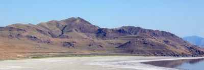
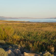
Lake Bonneville was a large body of water that covered parts of present-day Utah, Nevada and Idaho during the Late Pleistocene, reaching depths of around 300 meters (roughly 1000 feet) when conditions allowed maximum expansion. The Great Salt Lake, Utah Lake and several smaller bodies of water remain today as remnants of this once enormous basin, which shrank and vanished over thousands of years as the climate became drier.

The body of water formed roughly 30,000 years ago when cooler and wetter conditions filled the Great Basin, then began shrinking around 16,000 years ago as the climate warmed and dried. G.K. Gilbert, a geologist, studied the features left behind in the late 19th century and named the formation after explorer Benjamin Bonneville, who had traveled through the region decades earlier.

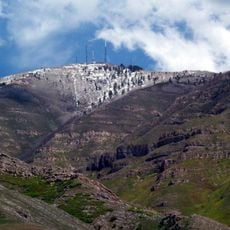
The name honors Benjamin Bonneville, a 19th-century Army officer and explorer whose travels across the western territories helped map uncharted lands and opened routes for settlers moving into the region. Hikers today notice pale horizontal lines along mountain slopes, visible traces of where water once lapped against rock and left mineral deposits as the climate shifted over thousands of years.

Hikers find horizontal bands along the slopes of the Wasatch Mountains and other ranges in the Great Basin, marking where the water once stood and slowly retreated over thousands of years. The best daylight hours in early morning or late afternoon help make these pale lines on rock faces easier to spot, especially after rain or when light comes in at a low angle.

Around 14,500 years ago, water broke through a natural barrier at Red Rock Pass and released a massive flood that surged across the Northwest, carving deep canyons into solid rock. This sudden drainage left behind bizarre erosion patterns along the Snake River, which geologists only properly understood in the 20th century when they realized the scale of one of the largest known floods on the North American continent.

The community of curious travelers

AroundUs brings together thousands of curated places, local tips, and hidden gems, enriched daily by 60,000 contributors worldwide.

Start exploring
Location
Location
Location
GPS coordinates
40.50000,-112.25000
Latest update
December 12, 2025 23:22
Around this place
Bingham Canyon Mine
United States of America

Bingham Canyon Mine

8.9 km
Oquirrh Mountain Utah Temple
United States of America

Oquirrh Mountain Utah Temple

22.9 km
Kennecott Smokestack
United States of America

Kennecott Smokestack

25.1 km
USANA Amphitheatre
United States of America

USANA Amphitheatre

25.2 km
Farnsworth Peak
United States of America

Farnsworth Peak

18.2 km
Butterfield Canyon
United States of America

Butterfield Canyon

14.8 km
United States of America

Black Rock

25.1 km
Bingham Canyon Reclamation Project
United States of America

Bingham Canyon Reclamation Project

8.7 km
Benson Grist Mill
United States of America

Benson Grist Mill

17.1 km
Waterfall Splash Pad
United States of America

Waterfall Splash Pad

24.6 km
Stockton Jail
United States of America

Stockton Jail

10.9 km
Hilda Erickson House
United States of America

Hilda Erickson House

21.7 km
Tooele County Courthouse and City Hall
United States of America

Tooele County Courthouse and City Hall

5.3 km
Alex and Mary Alice Johnson House
United States of America

Alex and Mary Alice Johnson House

21.2 km
James and Penninah Wrathall House
United States of America

James and Penninah Wrathall House

21.6 km
Grantsville First Ward Meetinghouse
United States of America

Grantsville First Ward Meetinghouse

22 km
Grantsville School and Meetinghouse
United States of America

Grantsville School and Meetinghouse

22 km
John T. Rich House
United States of America

John T. Rich House

21.9 km
Tooele Carnegie Library
United States of America

Tooele Carnegie Library

5.3 km
Ophir Town Hall
United States of America

Ophir Town Hall

14.5 km
Johnson Hall-Deseret Mercantile Building
United States of America

Johnson Hall-Deseret Mercantile Building

21.3 km
Cedar Fort School
United States of America

Cedar Fort School

22.8 km
David E. Davis House
United States of America

David E. Davis House

24 km
Reddick Hotel-Ophir LDS Meetinghouse
United States of America

Reddick Hotel-Ophir LDS Meetinghouse

14.5 km
Peter Clegg House
United States of America

Peter Clegg House

5.1 km
Stockton School
United States of America

Stockton School

10.8 km
Copperton Community Methodist Church
United States of America

Copperton Community Methodist Church

14.8 km
Sunset Beach
United States of America

Sunset Beach

25.4 km
Show the full map
Reviews
Share your experience

No review yet

Discussions
Start a discussion...

No discussion yet

« Lake Bonneville - Prehistoric pluvial lake in Utah, Nevada and Idaho, United States » is provided by Around Us (aroundus.com). Images and texts are derived from Wikimedia project under a Creative Commons license. You are allowed to copy, distribute, and modify copies of this page, under the conditions set by the license, as long as this note is clearly visible.

Discover hidden gems everywhere you go!

From secret cafés to breathtaking viewpoints, skip the crowded tourist spots and find places that match your style. Our app makes it easy with voice search, smart filtering, route optimization, and insider tips from travelers worldwide. Download now for the complete mobile experience.

Around Us App Screenshot

A unique approach to discovering new places

Le Figaro

All the places worth exploring

France Info

A tailor-made excursion in just a few clicks

20 Minutes

Around Us
Travel Guide & Maps
Download

Send to your phone

QR Code
1

Open the camera app on your mobile.

2

Point at the QR code with your camera. A notification will appear.

3

Tap the notification to open the link.