Chest opened
+${chestReward.xp} XP
Explorer
NOUVEAU ×${chestReward.collectible.quantity}
tapez pour fermer
Chest locked

Open chests in the app

Around Us is built for your phone — chests unlock when you walk, explore and capture nearby places.

Enable Location

We need your location to show you interesting places around you

Discover nearby places

Find interesting locations and hidden gems around you

Precise directions

Get accurate directions and distances to places

Your location is never shared with other users. It's only used when you tap the location button.

Log in to your account

Start exploring — it's free

Trusted by 72,931 travelers worldwide

Continue with Google
Continue with Apple
or

We will send you a code to connect

By continuing, you accept our Terms and Conditions and our Privacy Policy

Check your inbox

We've sent a pincode in your inbox. Please enter the code below.

San Juan Basin
Discussion Reviews Photo
17.9k Popularity

San Juan Basin, Structural basin in Four Corners region, United States

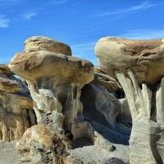
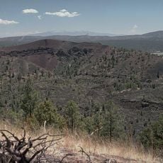
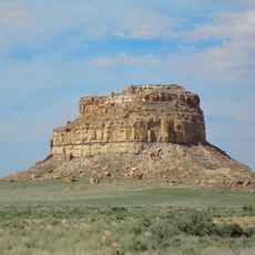
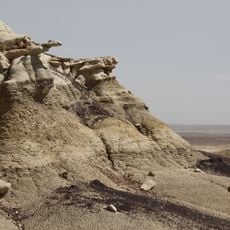
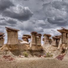
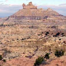
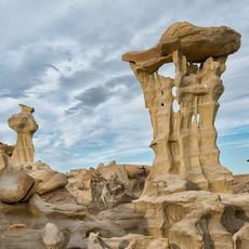
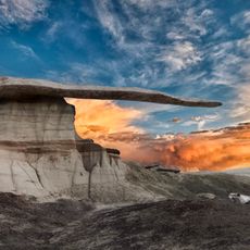
The San Juan Basin spans a large area of high plateaus, mesas, valleys, and plains across four states in the Four Corners region. The landscape is dry and open, marked by rock formations, deep canyons, and wide grasslands.

The basin formed over millions of years as tectonic forces pushed and shifted the earth's crust in this region. Layers of sediment accumulated and hardened, creating the rock formations and geological features visible today.

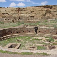
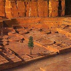
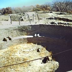
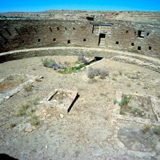
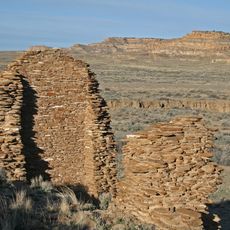
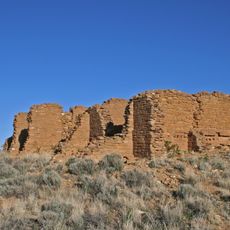
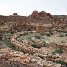
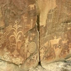
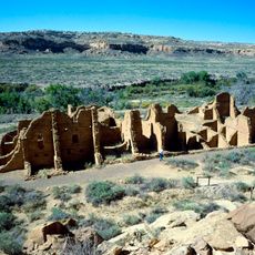
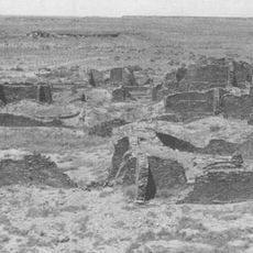
Native American groups built settlements and left behind archaeological sites throughout the region that visitors can still see today. These remnants show how people adapted to living in this dry landscape over many centuries.

Access to many areas is open, but some sections cross private or protected land, so check local rules before exploring. Spring and fall offer the most comfortable temperatures for visiting and walking around the landscape.

The basin produces significant amounts of natural gas, and scientists have tracked a large methane cloud hovering above it that can be detected from space. This invisible phenomenon reveals how energy extraction and environmental concerns are linked in this region.

The community of curious travelers

AroundUs brings together thousands of curated places, local tips, and hidden gems, enriched daily by 60,000 contributors worldwide.

Start exploring
Location
Location
Location
Location
GPS coordinates
36.27000,-107.90000
Latest update
December 7, 2025 19:23
Around this place
Chaco Culture National Historical Park
United States of America

Chaco Culture National Historical Park

24.2 km
Pueblo Bonito
United States of America

Pueblo Bonito

24 km
Bisti/De-Na-Zin Wilderness
United States of America

Bisti/De-Na-Zin Wilderness

19.9 km
United States of America

Chetro Ketl

23.8 km
Trail of the Ancients Scenic Byway
United States of America

Trail of the Ancients Scenic Byway

24.2 km
Fajada Butte
United States of America

Fajada Butte

28 km
Kirtland Formation
United States of America

Kirtland Formation

63.2 km
Ah-shi-sle-pah Wilderness
United States of America

Ah-shi-sle-pah Wilderness

11.6 km
Salmon Ruins
United States of America

Salmon Ruins

49.3 km
Casa Rinconada
United States of America

Casa Rinconada

24.6 km
Angel Peak Scenic Area
United States of America

Angel Peak Scenic Area

31.1 km
Una Vida
United States of America

Una Vida

26.3 km
Pueblo Alto
United States of America

Pueblo Alto

22.9 km
Pueblo del Arroyo
United States of America

Pueblo del Arroyo

24 km
Crow Canyon Archaeological District
United States of America

Crow Canyon Archaeological District

39.9 km
Kin Kletso
United States of America

Kin Kletso

23.7 km
Farmington Public Library
United States of America

Farmington Public Library

59 km
Farmington Historic Downtown Commercial District
United States of America

Farmington Historic Downtown Commercial District

57.9 km
Kin Bineola
United States of America

Kin Bineola

36.7 km
American Hotel
United States of America

American Hotel

61.7 km
Aztec Main Street Historic District
United States of America

Aztec Main Street Historic District

62.1 km
D.C. Ball House
United States of America

D.C. Ball House

62.2 km
Aztec Motor Company Building
United States of America

Aztec Motor Company Building

61.9 km
Engleman-Thomas Building
United States of America

Engleman-Thomas Building

62 km
Church Avenue-Lovers Lane Historic District
United States of America

Church Avenue-Lovers Lane Historic District

62.1 km
Valley of Dreams
United States of America

Valley of Dreams

15.3 km
King of Wings
United States of America

King of Wings

12.8 km
Aztec Museum
United States of America

Aztec Museum

62.2 km
Show the full map
Reviews
Share your experience

No review yet

Discussions
Start a discussion...

No discussion yet

« San Juan Basin - Structural basin in Four Corners region, United States » is provided by Around Us (aroundus.com). Images and texts are derived from Wikimedia project under a Creative Commons license. You are allowed to copy, distribute, and modify copies of this page, under the conditions set by the license, as long as this note is clearly visible.

Discover hidden gems everywhere you go!

From secret cafés to breathtaking viewpoints, skip the crowded tourist spots and find places that match your style. Our app makes it easy with voice search, smart filtering, route optimization, and insider tips from travelers worldwide. Download now for the complete mobile experience.

Around Us App Screenshot

A unique approach to discovering new places

Le Figaro

All the places worth exploring

France Info

A tailor-made excursion in just a few clicks

20 Minutes

Around Us
Travel Guide & Maps
Download

Send to your phone

QR Code
1

Open the camera app on your mobile.

2

Point at the QR code with your camera. A notification will appear.

3

Tap the notification to open the link.