Boulder Park, National Natural Landmark in Douglas County, Washington, United States
Boulder Park is a National Natural Landmark on the Waterville Plateau in Douglas County, Washington. Its broad, dish-shaped basin holds glacial erratics of granodiorite and gneiss carried south by the Okanogan ice lobe, alongside haystack rocks — basalt blocks ripped from the Columbia River Basalt Group that weather into talus piles resembling black haystacks.
Boulder Park lies on the Waterville Plateau, about 6 km northeast and 17 km north of the Withrow Moraine, the terminal moraine of the Okanogan ice lobe. That lobe, up to 300 m thick and 40 km wide, marked the southern margin of the Cordilleran Ice Sheet about 17,000 years ago. It left glacial erratics of granodiorite and gneiss plus local basalt haystack rocks.
The geological features of Boulder Park provide researchers and students with direct evidence of glacial processes during the last Ice Age.
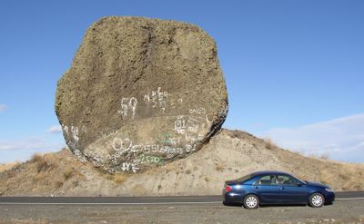
Boulder Park lies on the Waterville Plateau about 6 km northeast and 17 km north of the Withrow Moraine, reached by road; the boulder in the photograph sits directly beside the road, with a car parked at its base. The ground is covered by a discontinuous blanket of gravelly, sandy loam glacial till, so expect uneven footing. There are no marked trails in the sources; visitors move between erratics and haystack rocks on open ground.
Boulder Park holds two rock types side by side: glacial erratics of granodiorite and gneiss carried south by the Okanogan ice lobe, and haystack rocks of local Columbia River Basalt torn from the entablature. Because the haystack rocks match the bedrock beneath, they are not erratics. Weathering along basalt joints leaves talus piles that look like black haystacks from a distance.
The community of curious travelers
AroundUs brings together thousands of curated places, local tips, and hidden gems, enriched daily by 94,586 contributors worldwide.