Enable Location

We need your location to show you interesting places around you

Discover nearby places

Find interesting locations and hidden gems around you

Precise directions

Get accurate directions and distances to places

Your location is never shared with other users. It's only used when you tap the location button.

Log in to your account

Start exploring — it's free

Trusted by 65,840 travelers worldwide

Continue with Google
Continue with Apple
or

We will send you a code to connect

By continuing, you accept our Terms and Conditions and our Privacy Policy

Check your inbox

We've sent a pincode in your inbox. Please enter the code below.

Moyie Dam
Discussion Reviews Photo
3.7k Popularity

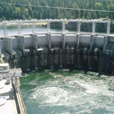
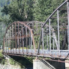
Moyie Dam, Gravity dam in Boundary County, Idaho, United States.

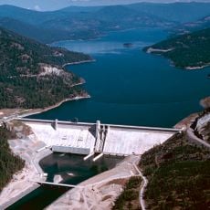
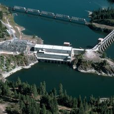
Moyie Dam is a concrete gravity dam on the Moyie River in northern Idaho, in Boundary County. It stands about 92 feet (28 meters) tall and channels water to three hydroelectric powerhouses located downstream.

A first dam was built on this site in 1923 but suffered a breach during a flood in 1925. The current structure was completed in 1950 to replace it.

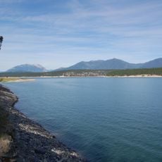
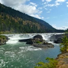
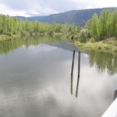
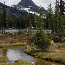
The dam supplies hydroelectric power directly to the nearby city of Bonners Ferry, making it one of the few municipally owned power sources in Idaho. The river below the dam is popular with anglers and people who enjoy spending time along the forested banks.

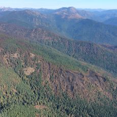
The dam can be viewed from outside and the surrounding river area is generally accessible to visitors on foot. A visit during the warmer months is advisable, as roads and trails in this part of northern Idaho can be difficult to reach in winter.

The 1923 dam was a thin-arch structure, a design that makes a dam much lighter than a solid gravity dam, and it breached in 1925 without fully collapsing. That rare outcome drew the attention of engineers and became a reference case in dam failure studies.

The community of curious travelers

AroundUs brings together thousands of curated places, local tips, and hidden gems, enriched daily by 60,000 contributors worldwide.

Start exploring
Location
GPS coordinates
48.73400,-116.17500
Latest update
March 3, 2026 14:01
Around this place
Lake Koocanusa
Canada

Lake Koocanusa

86.7 km
Libby Dam
United States of America

Libby Dam

73.3 km
Glass House
Canada

Glass House

85.4 km
Salmo-Priest Wilderness
United States of America

Salmo-Priest Wilderness

76.1 km
Colville National Forest
United States of America

Colville National Forest

87.3 km
Kootenai Falls
United States of America

Kootenai Falls

43.4 km
Albeni Falls Dam
United States of America

Albeni Falls Dam

86.7 km
Porthill-Rykerts Border Crossing
Canada

Porthill-Rykerts Border Crossing

38 km
Metaline Falls-Nelway Border Crossing
United States of America

Metaline Falls-Nelway Border Crossing

87.5 km
Kootenai National Wildlife Refuge
United States of America

Kootenai National Wildlife Refuge

17.4 km
Snowshoe Peak
United States of America

Snowshoe Peak

67.2 km
Moyie River Canyon Bridge
United States of America

Moyie River Canyon Bridge

603 m
Cabinet Gorge Dam
United States of America

Cabinet Gorge Dam

72.5 km
Round Lake State Park
United States of America

Round Lake State Park

72.1 km
Theodore Roosevelt Memorial Bridge
United States of America

Theodore Roosevelt Memorial Bridge

36.3 km
Kootenai Falls Swinging Bridge
United States of America

Kootenai Falls Swinging Bridge

43.1 km
Libby High School
United States of America

Libby High School

59.8 km
Kianuko Provincial Park
Canada

Kianuko Provincial Park

80.3 km
Metaline Falls Bridge
United States of America

Metaline Falls Bridge

89.1 km
Farmers and Merchants State Bank
United States of America

Farmers and Merchants State Bank

83.9 km
Cabinet National Forest
United States of America

Cabinet National Forest

82.7 km
Eureka Community Hall
United States of America

Eureka Community Hall

19.2 km
Dover Church
United States of America

Dover Church

62.7 km
Boundary County Courthouse
United States of America

Boundary County Courthouse

11 km
Amanda Nesbitt House
United States of America

Amanda Nesbitt House

57.8 km
Sandpoint Federal Building
United States of America

Sandpoint Federal Building

57.9 km
Russell and Pearl Soderling House
United States of America

Russell and Pearl Soderling House

11.6 km
Bull River Guard Station
United States of America

Bull River Guard Station

75.7 km
Show the full map
Reviews
Share your experience

No review yet

Discussions
Start a discussion...

No discussion yet

« Moyie Dam - Gravity dam in Boundary County, Idaho, United States » is provided by Around Us (aroundus.com). Images and texts are derived from Wikimedia project under a Creative Commons license. You are allowed to copy, distribute, and modify copies of this page, under the conditions set by the license, as long as this note is clearly visible.

Discover hidden gems everywhere you go!

From secret cafés to breathtaking viewpoints, skip the crowded tourist spots and find places that match your style. Our app makes it easy with voice search, smart filtering, route optimization, and insider tips from travelers worldwide. Download now for the complete mobile experience.

Around Us App Screenshot

A unique approach to discovering new places

Le Figaro

All the places worth exploring

France Info

A tailor-made excursion in just a few clicks

20 Minutes

Around Us
Travel Guide & Maps
Download

Send to your phone

QR Code
1

Open the camera app on your mobile.

2

Point at the QR code with your camera. A notification will appear.

3

Tap the notification to open the link.