Lone Butte, Geological formation in Cariboo Plateau, Canada.
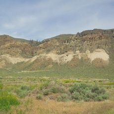
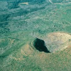
Lone Butte is a low, steep-sided mesa butte or volcanic plug on the southern Cariboo Plateau, 13 km southeast of 100 Mile House and just north of Green Lake. It is made of columnar basalt formed within a prehistoric volcano about six million years ago, part of the Chilcotin Group. The vertical structure rises more than 50 m above the surrounding lowlands and resembles Devils Tower in Wyoming.
This butte formed millions of years ago through geological processes that shaped the Cariboo Plateau and continues to define the landscape today. Early settlers and travelers in the region used it as a key navigation landmark in the vast terrain.
The ranching and recreational community of Lone Butte sits on the butte's north side, and the flat summit carries a BCWireless communication tower used as a main access point for broadband distribution. The butte rises beside Green Lake, a recreational lake community immediately to the south.
Lone Butte stands 13 km southeast of 100 Mile House, immediately north of Green Lake, with the ranching community of Lone Butte on its north side. The flat summit holds a BCWireless communication tower and a second Navigata tower sits on the eastern flank, so expect infrastructure at the top. Access is from the community side; the surrounding Cariboo Plateau terrain is flat to the south and hilly to the north.
Lone Butte is a volcanic plug of columnar basalt formed within a prehistoric volcano about six million years ago, part of the Chilcotin Group between the Coast Mountains and the mid-Fraser River. Its flat summit carries a BCWireless communication tower, while a Navigata tower stands on the eastern flank.
The community of curious travelers
AroundUs brings together thousands of curated places, local tips, and hidden gems, enriched daily by 94,036 contributors worldwide.