Enable Location

We need your location to show you interesting places around you

Discover nearby places

Find interesting locations and hidden gems around you

Precise directions

Get accurate directions and distances to places

Your location is never shared with other users. It's only used when you tap the location button.

Skydance Pedestrian Bridge

Log in to your account

Start exploring — it's free

Trusted by 61,907 travelers worldwide

Continue with Google
Continue with Apple
or

We will send you a code to connect

By continuing, you accept our Terms and Conditions and our Privacy Policy

Check your inbox

We've sent a pincode in your inbox. Please enter the code below.

Skydance Pedestrian Bridge

Skydance Pedestrian Bridge, Steel footbridge in downtown Oklahoma City, United States.

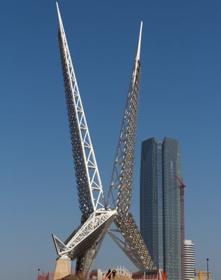
Skydance Pedestrian Bridge is a steel footbridge in downtown Oklahoma City that connects two sections of Scissortail Park across Interstate 40. It spans 380 feet (116 meters) with a width of 20 feet (6 meters) and rises 192 feet (59 meters) above the highway.

Construction began in August 2011 as a civic project to enhance park connections in downtown Oklahoma City. The bridge officially opened to the public in April 2012 with a ribbon-cutting ceremony.

The structure reflects design elements inspired by the mating ritual of the scissor-tailed flycatcher, Oklahoma's state bird. Visitors notice the curved shape that embodies this local symbol as they cross.

The crossing features a smooth, level surface that works well for walkers of all fitness levels. Bring water and sun protection on warm days, as shade is limited along the route.

After sunset, LED lighting systems illuminate the bridge with changing color patterns visible across downtown. This nighttime display transforms the structure into a popular spot for photographers and evening walks.

The community of curious travelers

AroundUs brings together thousands of curated places, local tips, and hidden gems, enriched daily by 60,000 contributors worldwide.

Start exploring
Location
GPS coordinates
35.45622,-97.51742
Latest update
December 8, 2025 19:41
Around this place
Skirvin Hilton Hotel
United States of America

Skirvin Hilton Hotel

1.5 km
Devon Energy Center
United States of America

Devon Energy Center

1.2 km
First National Center
United States of America

First National Center

1.4 km
Myriad Botanical Gardens
United States of America

Myriad Botanical Gardens

982 m
American Banjo Museum
United States of America

American Banjo Museum

1.3 km
Oklahoma City Museum of Art
United States of America

Oklahoma City Museum of Art

1.5 km
St. Joseph Old Cathedral
United States of America

St. Joseph Old Cathedral

1.8 km
City Place Tower
United States of America

City Place Tower

1.4 km
BancFirst Tower
United States of America

BancFirst Tower

1.4 km
Civic Center Music Hall
United States of America

Civic Center Music Hall

1.5 km
Colcord Hotel
United States of America

Colcord Hotel

1.2 km
Leadership Square
United States of America

Leadership Square

1.5 km
BOK Park Plaza
United States of America

BOK Park Plaza

1.2 km
Oklahoma Tower
United States of America

Oklahoma Tower

1.4 km
Oklahoma County Courthouse
United States of America

Oklahoma County Courthouse

1.4 km
Oklahoma Commons
United States of America

Oklahoma Commons

1.6 km
100 Park Avenue Building
United States of America

100 Park Avenue Building

1.4 km
United States Post Office, Courthouse, and Federal Office Building
United States of America

United States Post Office, Courthouse, and Federal Office Building

1.7 km
Calvary Baptist Church
United States of America

Calvary Baptist Church

1.7 km
Air Force Monument
United States of America

Air Force Monument

1.5 km
Galaxy
United States of America

Galaxy

1.5 km
Braniff Building
United States of America

Braniff Building

1.6 km
Oklahoma Publishing Company Building
United States of America

Oklahoma Publishing Company Building

1.8 km
Elks Lodge Building
United States of America

Elks Lodge Building

1.7 km
101 Park Avenue Building
United States of America

101 Park Avenue Building

1.4 km
Continental Oil Center
United States of America

Continental Oil Center

1.3 km
Bank of Oklahoma Plaza
United States of America

Bank of Oklahoma Plaza

1.6 km
Harkins Bricktown Cinemas
United States of America

Harkins Bricktown Cinemas

1.1 km
Show the full map
« Skydance Pedestrian Bridge - Steel footbridge in downtown Oklahoma City, United States » is provided by Around Us (aroundus.com). Images and texts are derived from Wikimedia project under a Creative Commons license. You are allowed to copy, distribute, and modify copies of this page, under the conditions set by the license, as long as this note is clearly visible.

Discover hidden gems everywhere you go!

From secret cafés to breathtaking viewpoints, skip the crowded tourist spots and find places that match your style. Our app makes it easy with voice search, smart filtering, route optimization, and insider tips from travelers worldwide. Download now for the complete mobile experience.

Around Us App Screenshot

A unique approach to discovering new places

Le Figaro

All the places worth exploring

France Info

A tailor-made excursion in just a few clicks

20 Minutes

Around Us
Travel Guide & Maps
Download

Send to your phone

QR Code
1

Open the camera app on your mobile.

2

Point at the QR code with your camera. A notification will appear.

3

Tap the notification to open the link.