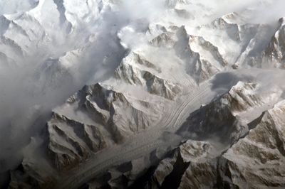
Xuelian Feng, Mountain summit in Baicheng County, China.
Xuelian Feng is a mountain with five distinct summits in the Tian Shan range, with the north peak reaching about 6,627 meters (21,740 feet) at its highest point. The terrain consists of glacier fields and rocky ridges that define the shape of this alpine massif.
The first successful ascent took place on August 19, 1990, when eight Japanese mountaineers reached the summit after earlier attempts had failed. This climb marked a significant milestone in the mountaineering history of the region.
The name Snow Lotus Peak refers to white alpine flowers that bloom on the slopes surrounding the mountain. Visitors climbing the lower sections notice these flowers dotting the landscape during the warmer months.
The standard approach follows the Karakume Glacier, crossing a snow and rock ridge spanning about two kilometers to reach the main summit. The route demands mountaineering experience and stable weather conditions for safe progression.
This peak stands out globally for its topographic prominence, rising approximately 3,068 meters (10,065 feet) above the surrounding valleys in one dramatic rise. This stark elevation change makes it a distinctive geographical landmark when viewed from lower elevations.
The community of curious travelers
AroundUs brings together thousands of curated places, local tips, and hidden gems, enriched daily by 60,000 contributors worldwide.