Chest opened
+${chestReward.xp} XP
Explorer
NOUVEAU ×${chestReward.collectible.quantity}
tapez pour fermer
Chest locked

Open chests in the app

Around Us is built for your phone — chests unlock when you walk, explore and capture nearby places.

Enable Location

We need your location to show you interesting places around you

Discover nearby places

Find interesting locations and hidden gems around you

Precise directions

Get accurate directions and distances to places

Your location is never shared with other users. It's only used when you tap the location button.

USS Monitor

Log in to your account

Start exploring — it's free

Trusted by 73,069 travelers worldwide

Continue with Google
Continue with Apple
or

We will send you a code to connect

By continuing, you accept our Terms and Conditions and our Privacy Policy

Check your inbox

We've sent a pincode in your inbox. Please enter the code below.

Discussion Reviews 1 Photos
208k Popularity

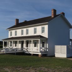
USS Monitor, Warship in the United States of America

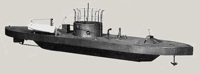
The USS Monitor was an armored warship with a low hull and rotating gun turret, built during the American Civil War. This vessel looked unlike any other military ship of its era, featuring a radical design that set it apart from conventional naval construction.

Built in 1862, the vessel immediately engaged in a decisive battle where it fought a traditional wooden warship to a standoff, proving that armor could challenge conventional naval power. This confrontation marked the end of wooden warship dominance globally.

This vessel changed how naval combat was understood and sparked a global shift toward armored ships in every navy. Visitors can sense how one bold design challenged centuries of wooden shipbuilding tradition.

The wreck rests deep in the Atlantic Ocean off North Carolina's coast and can only be reached by specialized diving expeditions. The depth and underwater conditions mean that access is limited to experienced divers with proper training and equipment.

The wreck was discovered on the ocean floor in 1973, and in 2002 a chamber from the hull was brought to the surface for investigation. This salvage mission allowed historians to learn details about how the crew lived aboard this groundbreaking vessel.

The community of curious travelers

AroundUs brings together thousands of curated places, local tips, and hidden gems, enriched daily by 60,000 contributors worldwide.

Start exploring
Location
Exclusive economic zone of the United States
Location
Official opening
January 30, 1862
Part of
United States Navy monitor fleet
GPS coordinates
35.00167,-75.40639
Latest update
December 8, 2025 08:20
Around this place
Cape Hatteras Lighthouse
United States of America

Cape Hatteras Lighthouse

29.9 km
Bodie Island Light
United States of America

Bodie Island Light

92 km
Cape Lookout National Seashore
United States of America

Cape Lookout National Seashore

87.5 km
Alligator River National Wildlife Refuge
United States of America

Alligator River National Wildlife Refuge

95.9 km
Diamond Shoal Light
United States of America

Diamond Shoal Light

19.6 km
Pea Island National Wildlife Refuge
United States of America

Pea Island National Wildlife Refuge

73.9 km
Ocracoke Light
United States of America

Ocracoke Light

54.2 km
Graveyard of the Atlantic Museum
United States of America

Graveyard of the Atlantic Museum

35.4 km
Rodanthe Bridge
United States of America

Rodanthe Bridge

68 km
Chicamacomico Life-Saving Station
United States of America

Chicamacomico Life-Saving Station

66.3 km
Coquina Beach
United States of America

Coquina Beach

93.8 km
Mattamuskeet National Wildlife Refuge
United States of America

Mattamuskeet National Wildlife Refuge

91 km
Roanoke Marshes Light
United States of America

Roanoke Marshes Light

94 km
Cedar Island National Wildlife Refuge
United States of America

Cedar Island National Wildlife Refuge

80 km
United States of America

Naval Facility Cape Hatteras

30.4 km
Salvo Post Office
United States of America

Salvo Post Office

60.2 km
Lake Mattamuskeet Pump Station
United States of America

Lake Mattamuskeet Pump Station

86 km
Bodie Island Lifesaving and Coast Guard Station
United States of America

Bodie Island Lifesaving and Coast Guard Station

93.2 km
Inkwell
United States of America

Inkwell

79.7 km
Hatteras Weather Bureau Station
United States of America

Hatteras Weather Bureau Station

35.5 km
Rasmus Midgett House
United States of America

Rasmus Midgett House

60.8 km
Ellsworth and Lovie Ballance House
United States of America

Ellsworth and Lovie Ballance House

35.5 km
Bodie Island Light Station
United States of America

Bodie Island Light Station

92.1 km
Bodie Island Visitor Center
United States of America

Bodie Island Visitor Center

92 km
North Pond Wildlife Trail
United States of America

North Pond Wildlife Trail

79.9 km
Pea Island National Wildlife Refuge Visitor Center
United States of America

Pea Island National Wildlife Refuge Visitor Center

80 km
Pea Island Beach
United States of America

Pea Island Beach

80.4 km
Herbert C. Bonner Bridge
United States of America

Herbert C. Bonner Bridge

86.5 km
Show the full map
Reviews
Share your experience

No review yet

Discussions
Start a discussion...

No discussion yet

« USS Monitor - Warship in the United States of America » is provided by Around Us (aroundus.com). Images and texts are derived from Wikimedia project under a Creative Commons license. You are allowed to copy, distribute, and modify copies of this page, under the conditions set by the license, as long as this note is clearly visible.

Discover hidden gems everywhere you go!

From secret cafés to breathtaking viewpoints, skip the crowded tourist spots and find places that match your style. Our app makes it easy with voice search, smart filtering, route optimization, and insider tips from travelers worldwide. Download now for the complete mobile experience.

Around Us App Screenshot

A unique approach to discovering new places

Le Figaro

All the places worth exploring

France Info

A tailor-made excursion in just a few clicks

20 Minutes

Around Us
Travel Guide & Maps
Download

Send to your phone

QR Code
1

Open the camera app on your mobile.

2

Point at the QR code with your camera. A notification will appear.

3

Tap the notification to open the link.