Chest opened
+${chestReward.xp} XP
Explorer
NOUVEAU ×${chestReward.collectible.quantity}
tapez pour fermer
Chest locked

Open chests in the app

Around Us is built for your phone — chests unlock when you walk, explore and capture nearby places.

Enable Location

We need your location to show you interesting places around you

Discover nearby places

Find interesting locations and hidden gems around you

Precise directions

Get accurate directions and distances to places

Your location is never shared with other users. It's only used when you tap the location button.

Log in to your account

Start exploring — it's free

Trusted by 72,882 travelers worldwide

Continue with Google
Continue with Apple
or

We will send you a code to connect

By continuing, you accept our Terms and Conditions and our Privacy Policy

Check your inbox

We've sent a pincode in your inbox. Please enter the code below.

Conejohela Flats
Discussion Reviews Photo
1.6k Popularity

Conejohela Flats, Bird observation area along Susquehanna River, Pennsylvania.

Conejohela Flats is a wetland ecosystem along the Susquehanna River comprising multiple islands that provide habitat for migratory bird species. The shallow waters and muddy areas between the islands form a connected system supporting wading and shoreline birds.

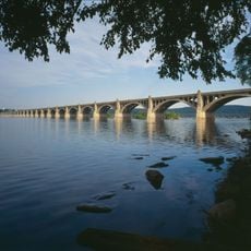
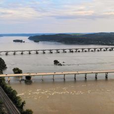
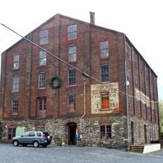
Three major dams constructed between 1910 and 1931 transformed the valley into a system of flooded islands and wetlands. These dam projects unintentionally created new habitats that later became critical resting sites for migratory birds.

Birdwatchers from the area gather year-round at this location to document and photograph species that stop on the river islands. The flats have become a popular meeting place for local nature enthusiasts who regularly share their sightings with one another.

Reaching the flats requires a kayak or boat, with launching points available near the Veterans Memorial Bridge in Lancaster County. It helps to paddle during calm weather and pay attention to tide times, as water levels can shift considerably.

The flats contain specialized mud zones in shallow waters that attract rare species such as American Avocets and Whimbrels. These conditions resulted from the dam structures and now form an unexpected habitat for wading birds normally found along coasts.

The community of curious travelers

AroundUs brings together thousands of curated places, local tips, and hidden gems, enriched daily by 60,000 contributors worldwide.

Start exploring
GPS coordinates
39.98600,-76.47400
Latest update
December 14, 2025 14:22
Around this place
Columbia–Wrightsville Bridge
United States of America

Columbia–Wrightsville Bridge

6 km
Safe Harbor Dam
United States of America

Safe Harbor Dam

10.1 km
United States of America

Chickies Ridge

8.5 km
Conestoga Town
United States of America

Conestoga Town

6.9 km
Samuel S. Lewis State Park
United States of America

Samuel S. Lewis State Park

6.5 km
Wright's Ferry Bridge
United States of America

Wright's Ferry Bridge

7 km
Safe Harbor Bridge
United States of America

Safe Harbor Bridge

10.2 km
Siegrist's Mill Covered Bridge
United States of America

Siegrist's Mill Covered Bridge

10 km
Donegal Mills Plantation
United States of America

Donegal Mills Plantation

12.4 km
Wright's Ferry Mansion
United States of America

Wright's Ferry Mansion

5.4 km
Forry's Mill Covered Bridge
United States of America

Forry's Mill Covered Bridge

9 km
Columbia Historic District
United States of America

Columbia Historic District

5.9 km
Dritt Mansion
United States of America

Dritt Mansion

2.2 km
Marietta Historic District
United States of America

Marietta Historic District

10.6 km
Chickies Historic District
United States of America

Chickies Historic District

10.7 km
Bausman Farmstead
United States of America

Bausman Farmstead

12.6 km
Martin Schultz House
United States of America

Martin Schultz House

11.6 km
Byrd Leibhart Site
United States of America

Byrd Leibhart Site

2.2 km
Linden House
United States of America

Linden House

10 km
Strickler Site
United States of America

Strickler Site

1.3 km
Bachman and Forry Tobacco Warehouse
United States of America

Bachman and Forry Tobacco Warehouse

5.5 km
Burgholtshouse
United States of America

Burgholtshouse

4.2 km
Frey-Haverstick Site
United States of America

Frey-Haverstick Site

1 km
Murry Site
United States of America

Murry Site

2 km
Manor Street Elementary School
United States of America

Manor Street Elementary School

4.8 km
Shultz-Funk Site
United States of America

Shultz-Funk Site

2.5 km
Wrightsville Historic District
United States of America

Wrightsville Historic District

6.2 km
Christian Habeck Farm
United States of America

Christian Habeck Farm

12.6 km
Show the full map
Reviews
Share your experience

No review yet

Discussions
Start a discussion...

No discussion yet

« Conejohela Flats - Bird observation area along Susquehanna River, Pennsylvania » is provided by Around Us (aroundus.com). Images and texts are derived from Wikimedia project under a Creative Commons license. You are allowed to copy, distribute, and modify copies of this page, under the conditions set by the license, as long as this note is clearly visible.

Discover hidden gems everywhere you go!

From secret cafés to breathtaking viewpoints, skip the crowded tourist spots and find places that match your style. Our app makes it easy with voice search, smart filtering, route optimization, and insider tips from travelers worldwide. Download now for the complete mobile experience.

Around Us App Screenshot

A unique approach to discovering new places

Le Figaro

All the places worth exploring

France Info

A tailor-made excursion in just a few clicks

20 Minutes

Around Us
Travel Guide & Maps
Download

Send to your phone

QR Code
1

Open the camera app on your mobile.

2

Point at the QR code with your camera. A notification will appear.

3

Tap the notification to open the link.