See the monuments around you in AROpen chests in the app
Around Us is built for your phone — point your camera at the streets and discover the monuments and places around you in augmented reality.Around Us is built for your phone — chests unlock when you walk, explore and capture nearby places.
Namibia travel guide: national parks, desert landscapes, cultural sites
Namibia offers travelers a diverse landscape of natural wonders and historical landmarks that span vast desert plains, dramatic canyons, and protected wildlife reserves. The country's attractions range from Etosha National Park, where large herds gather at waterholes across more than 8,500 square miles (22,000 square kilometers) of protected land, to the towering red dunes of Sossusvlei rising 1,000 feet (300 meters) above white salt pans. Fish River Canyon cuts 100 miles (160 kilometers) through the southern landscape, while along the Atlantic coast, the Skeleton Coast preserves the remains of ships lost in foggy waters and hosts thriving seal colonies. Rock engravings at Twyfelfontein, created by San peoples over 6,000 years ago, document ancient wildlife and spiritual practices through more than 2,500 carvings in red sandstone.
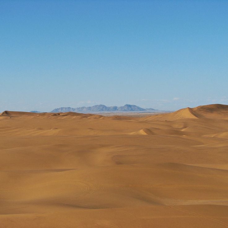
The Namib Desert, one of Earth's oldest arid regions, supports specialized wildlife and plant species that have adapted to extreme conditions over millions of years. Conservation areas like Okonjima protect cheetahs and leopards through research and rehabilitation programs, while coastal wetlands at Pelican Point and Sandwich Harbour provide feeding grounds for flamingos, pelicans, and thousands of Cape fur seals. The collection also includes Kolmanskop, a German colonial diamond mining settlement from 1908 that now stands abandoned as sand dunes gradually reclaim its buildings. These destinations demonstrate how human history, geological forces, and resilient ecosystems have shaped this southwestern African nation into a compelling destination for nature and culture enthusiasts.
Namibia travel guide: national parks, desert landscapes, cultural sites
Namibia offers travelers a diverse landscape of natural wonders and historical landmarks that span vast desert plains, dramatic canyons, and protected wildlife reserves. The country's attractions range from Etosha National Park, where large herds gather at waterholes across more than 8,500 square miles (22,000 square kilometers) of protected land, to the towering red dunes of Sossusvlei rising 1,000 feet (300 meters) above white salt pans. Fish River Canyon cuts 100 miles (160 kilometers) through the southern landscape, while along the Atlantic coast, the Skeleton Coast preserves the remains of ships lost in foggy waters and hosts thriving seal colonies. Rock engravings at Twyfelfontein, created by San peoples over 6,000 years ago, document ancient wildlife and spiritual practices through more than 2,500 carvings in red sandstone.
The Namib Desert, one of Earth's oldest arid regions, supports specialized wildlife and plant species that have adapted to extreme conditions over millions of years. Conservation areas like Okonjima protect cheetahs and leopards through research and rehabilitation programs, while coastal wetlands at Pelican Point and Sandwich Harbour provide feeding grounds for flamingos, pelicans, and thousands of Cape fur seals. The collection also includes Kolmanskop, a German colonial diamond mining settlement from 1908 that now stands abandoned as sand dunes gradually reclaim its buildings. These destinations demonstrate how human history, geological forces, and resilient ecosystems have shaped this southwestern African nation into a compelling destination for nature and culture enthusiasts.
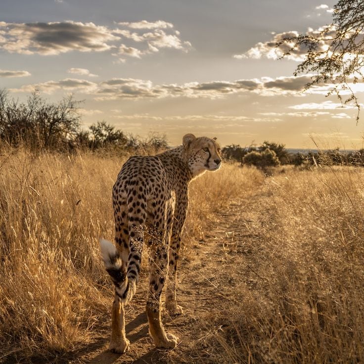
Okonjima is a 77-square-mile (200 square kilometers) conservation area in Otjozondjupa Region dedicated to the protection of cheetahs and leopards. The AfriCat Foundation operates research and protection programs for big cats in their natural habitat at this location. The reserve provides insight into conservation efforts for endangered predator species and their rehabilitation. The facility documents the behavior and population dynamics of these animals in the Namibian wilderness.
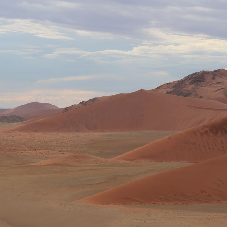
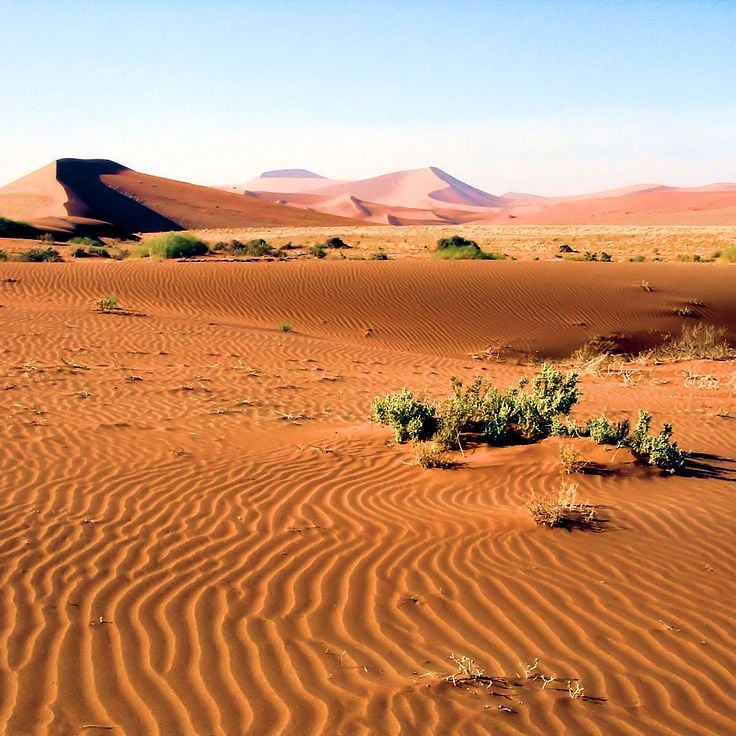
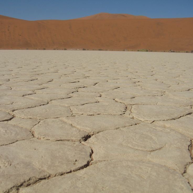
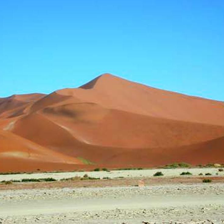
This desert valley in the Namib Desert contains distinctive ochre sand dunes that rise to approximately 1,000 feet (300 meters). The terrain forms part of one of Earth's oldest arid zones and presents a contrast between reddish dune formations and white salt pans at the valley floor. Sossusvlei ranks among Namibia's most recognized geological formations and demonstrates the extreme conditions under which desert landscapes develop over millions of years. The formation lies within Namib-Naukluft Park and represents typical features of the Namib Desert with its dune fields and dry vegetation.
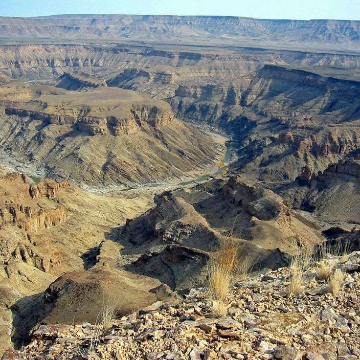
This canyon ranks among the most significant natural formations in Namibia. Fish River Canyon extends 100 miles (160 kilometers) in length and reaches a depth of 1,800 feet (550 meters). The Fish River, which flows through the formation, carries water only during certain seasons. The gorge provides insight into geological processes that developed over millions of years and demonstrates the adaptability of flora and fauna to arid conditions. Trails along the canyon rim and through the riverbed enable exploration of this natural landscape.
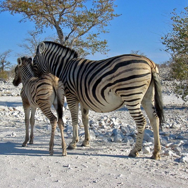
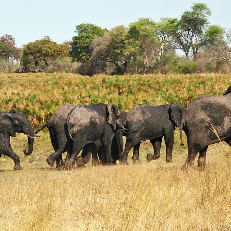
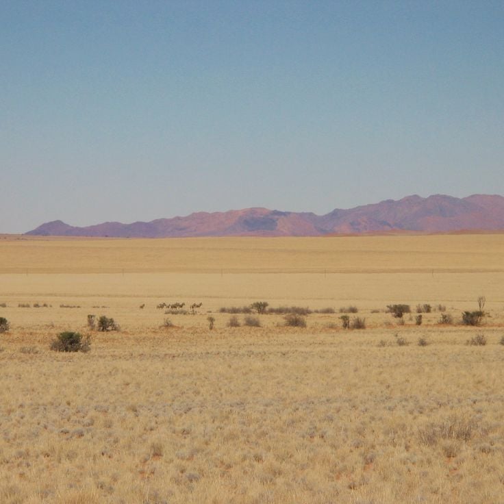
This national park covers more than 8,500 square miles (22,000 square kilometers) in northern Namibia, protecting diverse ecosystems around the expansive Etosha salt pan. The park's waterholes attract large herds of elephants, zebras, wildebeest, and various antelope species during the dry season. Lions, leopards, cheetahs, and hyenas inhabit this area. More than 340 bird species have been recorded here, including ostriches and various raptors. The salt pan itself covers approximately 1,850 square miles (4,800 square kilometers) and occasionally fills with water after heavy rains, drawing flamingos and other water birds. Several camps within the park provide access to observation points and floodlit waterholes for nighttime wildlife viewing.
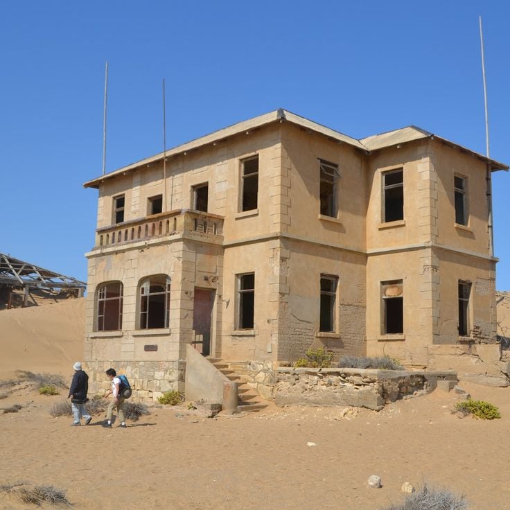
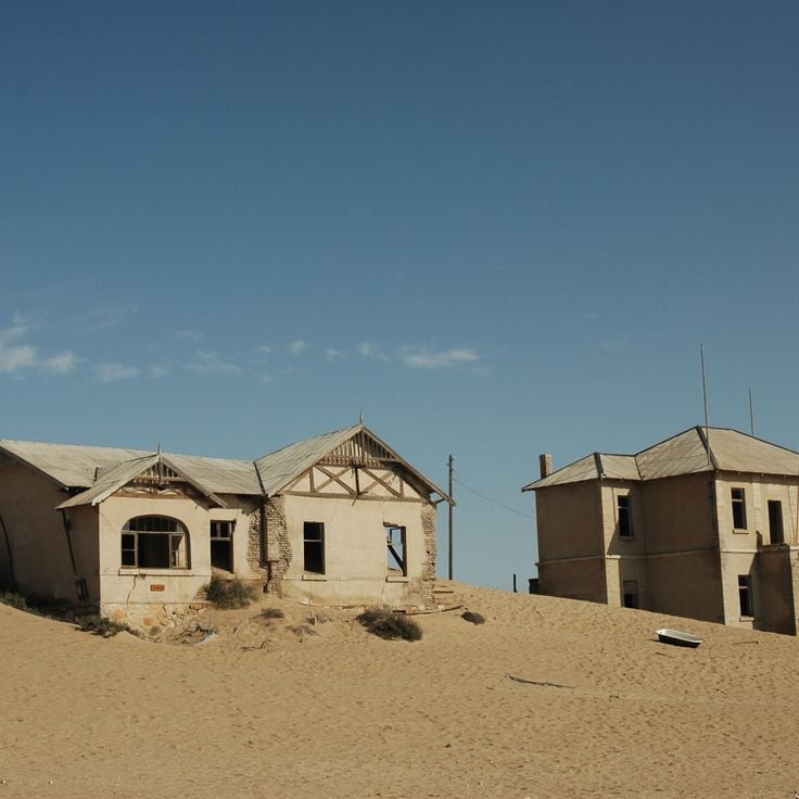
This former diamond mining town was established in 1908 during the diamond rush in the Namib Desert. Kolmanskop grew rapidly into a prosperous settlement with German colonial architecture, including residential buildings, a hospital, a school, and a casino. After diamond deposits declined in the 1930s, the town was abandoned. Today, sand dunes invade the empty structures, creating a landscape that demonstrates the contrast between human settlement and the power of the desert.
This park covers 49,768 square kilometers (19,216 square miles) and is the largest conservation area in Namibia. It combines the Namib Desert with the Naukluft Mountains and provides habitat for oryx and zebras. As part of Namibia's desert landscapes, Namib-Naukluft Park complements the country's natural sites, which include the red dunes of Sossusvlei and other nature reserves hosting wildlife and flora adapted to dry conditions.
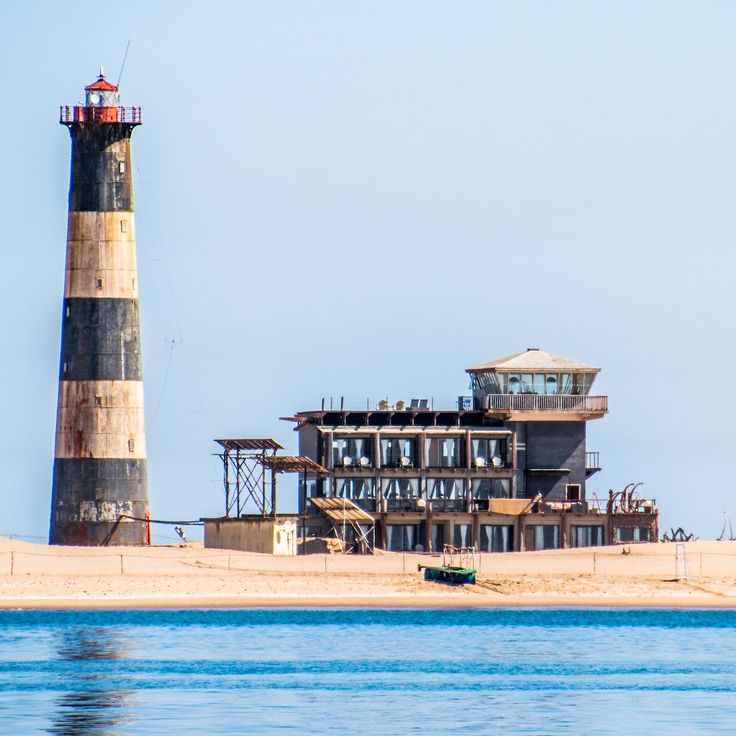
This sandy peninsula on the coast of Walvis Bay is home to a historic lighthouse built in 1932 and one of the largest colonies of Cape fur seals in Namibia. The peninsula extends 7 miles (11 kilometers) into the bay and provides habitat for several thousand seals that gather on the sandbanks and shoreline. The red and white striped lighthouse continues to serve navigation for vessels approaching Walvis Bay harbor. The shallow waters and lagoons surrounding Pelican Point attract pelicans, flamingos, and other coastal birds. The peninsula is accessible only by a long sandy track or by boat and lies within the boundaries of the Walvis Bay Lagoon Ramsar wetland site.
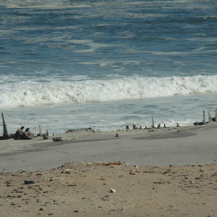
This coastal region extends over 300 miles (500 kilometers) along the Atlantic and is part of the collection of Namibia's natural and historical sites. The Skeleton Coast displays numerous shipwrecks that lie on the beaches, remains of vessels that ran aground in the foggy and dangerous waters. The protected coastal zone hosts large seal colonies that have settled at several locations along the shore. This region lies in the northern part of the country and connects the Namib Desert with the ocean, where cool ocean currents and dry desert climate meet.
Sandwich Harbour is a saltwater lagoon in the Erongo Region where a peninsula meets the high sand dunes of the Namib Desert and the Atlantic Ocean. This site provides habitat for flamingos, pelicans, and other waterbirds that feed in the shallow waters. The dunes reach heights of up to 330 feet (100 meters) and extend to the sea. The area is accessible only by four-wheel-drive vehicles at low tide. This lagoon complements the understanding of Namibia's coastal ecosystems along the Namib Desert.
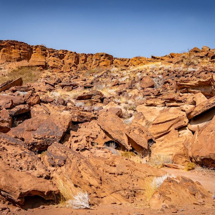
This archaeological site contains over 2500 rock engravings dating back 6000 years, depicting animals such as giraffes, elephants, rhinoceroses, and antelopes, along with geometric figures. Twyfelfontein is located in the Kunene Region and represents one of the most important concentrations of prehistoric art in southern Africa. The engravings were created by San peoples who carved the images into red sandstone, documenting their way of life and spiritual beliefs. This site adds a significant cultural dimension to Namibia's natural and historical attractions like Etosha and Sossusvlei.
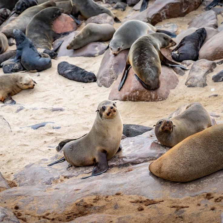
This marine reserve hosts one of the largest Cape fur seal colonies along the Namibian coast, with more than 100,000 animals inhabiting and breeding at this protected coastal location. The seal colony provides visitors with opportunities to observe the behavior of these marine mammals in their natural environment. A stone cross erected in 1486 by Portuguese navigator Diogo Cão stands at the site, representing one of the oldest European monuments in southern Africa. This combination of wildlife and history makes Cape Cross a notable point among Namibia's natural and historical attractions.
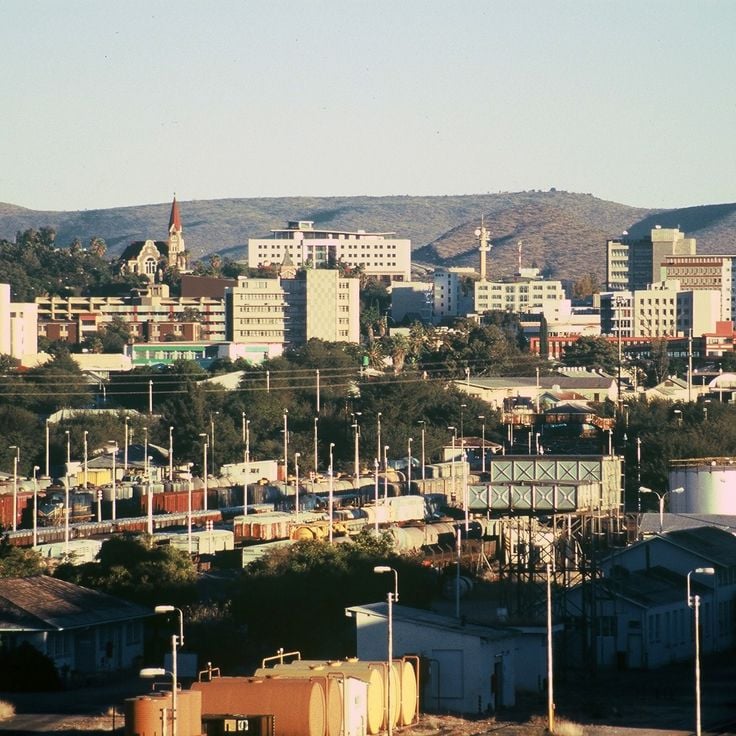
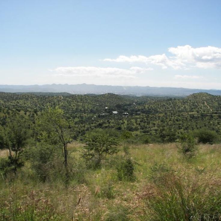
This city serves as the administrative and economic center of Namibia and sits at an elevation of 5,577 feet (1,700 meters). Windhoek houses major government institutions including Parliament, the Supreme Court, and the Central Bank. As the national capital, the city functions as a gateway for visitors exploring Namibia's principal natural sites and historical locations, from Etosha National Park and the Sossusvlei dunes to the coastal town of Swakopmund.
The Waterberg Plateau rises approximately 650 feet (200 meters) above the surrounding plains of the Otjozondjupa Region, forming a distinctive sandstone massif. This plateau is part of Namibia's network of protected areas and provides habitat for endangered species including black rhinoceroses and various antelope species. The vegetation on the plateau differs markedly from the arid surroundings, benefiting from higher rainfall. The area plays an important role in Namibia's conservation efforts and complements other significant natural sites such as Etosha National Park and the Namib Desert.
Deadvlei is a white clay basin in Namib-Naukluft National Park, surrounded by orange dunes reaching up to 1,000 feet (300 meters). The black acacia trunks in this basin died roughly 900 years ago when the Tsauchab River changed course and the trees withered. The dry desert air preserved the dead trees, which could not decompose due to lack of moisture. Deadvlei sits about 1.2 miles (2 kilometers) from Sossusvlei and represents one of the photographed landscapes in Namibia.
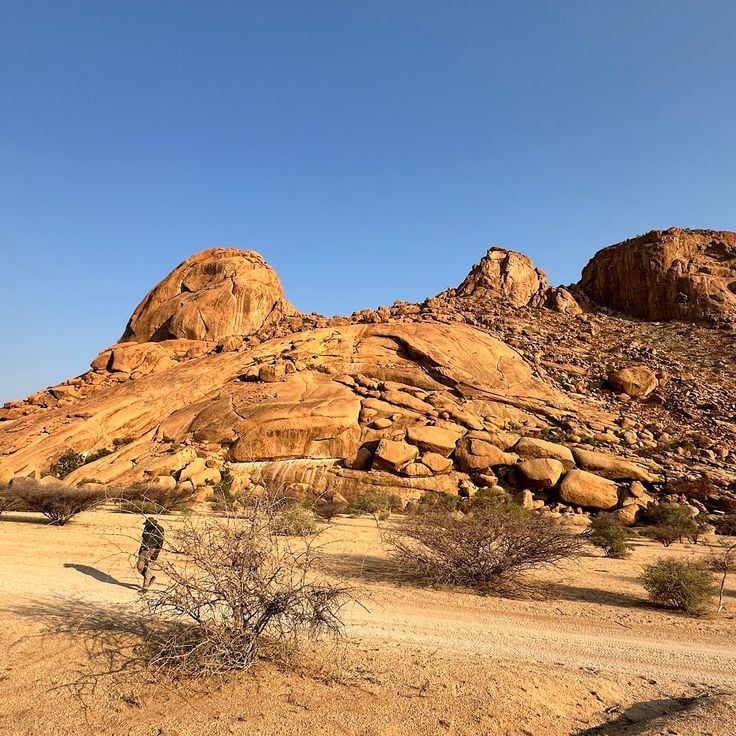
Spitzkoppe rises 2,297 feet (700 meters) above the Namib Desert and consists of granite formations that formed over 120 million years ago. This rock formation displays ancient San rock paintings dating back up to 4,000 years. Spitzkoppe is often called the Matterhorn of Namibia due to its pointed shape and offers climbing routes and hiking trails through the granite landscape. The area represents one of Namibia's geological features and complements the natural landscapes of Etosha National Park, Sossusvlei, and Fish River Canyon.
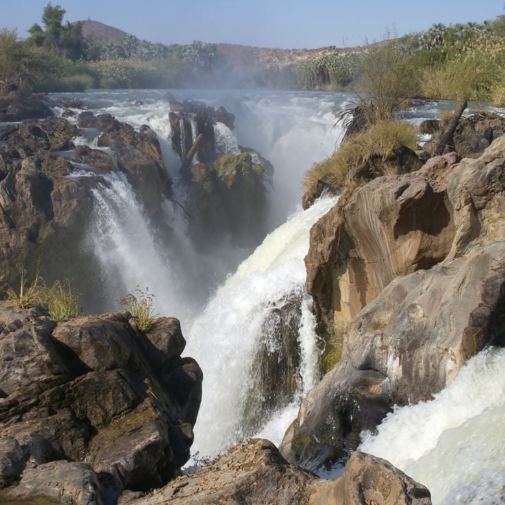
The Epupa Falls represent one of northern Namibia's significant natural features along the Kunene River, which forms the border with Angola. These waterfalls extend for 0.9 miles (1.5 kilometers) and reach a maximum height of 120 feet (37 meters). The water cascades over multiple drops into deep pools, surrounded by fan palms and baobab trees. The Epupa Falls lie within Himba territory, whose traditional settlements are found in this region, and offer insight into the adaptation of life and culture to the harsh conditions of northwestern Namibia.
Bwabwata Park covers 6,100 square miles (15,800 square kilometers) between the Okavango and Kwando Rivers and provides habitat for elephants, buffaloes, and antelopes. This protected area in the Zambezi Region forms an important wildlife corridor connecting Angola, Botswana, Zambia, and Zimbabwe. The park supports various antelope species and large mammals adapted to arid conditions, complementing Namibia's network of nature reserves and national parks that protect wildlife and flora across the country's diverse landscapes.
The Caprivi Strip is a narrow corridor of land in northeastern Namibia extending between Botswana to the south, Angola to the north, and Zambia to the east. This region encompasses several national parks and conservation areas, including Bwabwata, Mudumu, and Nkasa Rupara, known for their elephant populations and water-rich landscape. The area differs notably from the rest of arid Namibia through its rivers and wetlands, providing habitat for diverse wildlife. The Caprivi Strip was officially renamed Zambezi Region in 2013.
This nature reserve spans 3950 hectares (9760 acres) in the Khomas Highlands and serves as an accessible wildlife refuge near Windhoek. Daan Viljoen hosts populations of mountain zebras, kudus, oryx, and wildebeest, along with a substantial bird population of more than 200 recorded species. The reserve features hiking trails that traverse hilly terrain covered with acacia and aloe vegetation. Located 15 miles (24 kilometers) west of the capital, it functions as a frequently visited destination for day trips and weekend stays. Established in 1962, this protected area plays an important role in wildlife conservation in central Namibia.
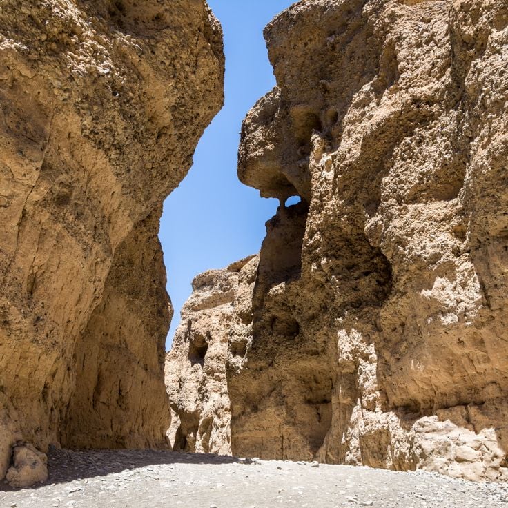
This canyon was carved by the Tsauchab River over millions of years through 30 feet (9 meters) of sedimentary rock layers and extends for about two thirds of a mile (1 kilometer) through the Namib Desert. Sesriem Canyon displays various rock strata that provide insights into geological processes and climatic changes in the region. The canyon serves as an access point to the dunes of Sossusvlei and offers visitors opportunities to explore Namibia's geological formations in an area where water flow represents a rare but defining force in the desert landscape.
Naankuse is a 22,240-acre (9,000-hectare) nature reserve focused on the research and rehabilitation of cheetahs and other large carnivores. This facility contributes to understanding Namibia's wildlife and provides programs for reintroducing threatened species to their natural habitats. Located in the Khomas Region, the reserve complements the country's nature reserves and national parks through its work with mammals adapted to arid conditions. Visitors can learn about ongoing conservation efforts for Namibia's fauna and the challenges of human-wildlife coexistence in semiarid landscapes.
This national park extends 200 miles (320 kilometers) along the Atlantic coast, connecting beaches, desert landscapes, and marine conservation zones. Dorob Park protects the transition zone between the Namib Desert and the ocean, hosting seal colonies, seabirds, and desert organisms adapted to extreme aridity. The park lies between Skeleton Coast National Park to the north and Namib-Naukluft Park to the south, contributing to the preservation of Namibia's natural coastal ecosystems featured in this collection.
This dune is a prominent sand formation in the Namib Desert, rising 383 feet (117 meters) high and ranking among the tallest dunes in Africa. The red color of the sand results from iron oxide formed through weathering processes. Dune 7 sits on the outskirts of Walvis Bay and offers visitors the opportunity to climb the steep slope and view the desert landscape. Access is provided via a paved road. This formation is among the notable geological features that characterize Namibia's desert regions, which also include the red dunes of Sossusvlei and other natural sites such as Etosha National Park.
This national park in southern Namibia encompasses a former diamond mining area that was closed to the public for over a century. The Sperrgebiet extends along the Atlantic coast and now protects the distinctive desert flora of the Namib, including numerous endemic plant species adapted to extreme arid conditions. The area also preserves historic mining installations and abandoned settlements from the colonial era. Visits are permitted only through guided tours that provide insights into the natural history and mining past of the region.
This remote mountainous region in northwestern Namibia constitutes the traditional territory of the Himba people, a semi-nomadic ethnic group who maintain their ancestral customs and way of life. Kaokoland extends across approximately 19,300 square miles (50,000 square kilometers) of arid, rocky terrain characterized by rugged mountains, deep valleys, and seasonal rivers. The area supports populations of desert-adapted elephants that traverse the riverbeds, along with giraffes, springbok, and oryx. Himba communities live in scattered settlements and practice pastoralism, with cattle holding central importance to their culture. The region ranks among Namibia's most sparsely populated areas and preserves an isolated wilderness with minimal modern development.
This 3,842 square kilometer (1,483 square mile) protected area lies in northeastern Namibia along the border with Botswana. The region enables free movement of elephants, lions, leopards, and other large mammals between both countries. Khaudom Park forms part of Namibia's network of natural reserves that preserve habitats adapted to the arid conditions of the Kalahari Desert. Vegetation consists of acacia and mopane woodlands along with open savannas that attract wildlife during rainy seasons. The area provides access to remote wilderness with minimal tourism infrastructure.
Nkasa Rupara Park protects 320 square kilometers (124 square miles) of wetland in Namibia's Zambezi Region, comprising two islands within the Kwando-Linyanti river system. This nature reserve provides habitat for hippopotamuses, crocodiles, and other species adapted to aquatic environments. The floodplains contrast with the arid landscapes that characterize much of Namibia, supporting waterbirds and large mammals. The park complements Namibia's network of protected areas with its focus on wetland ecosystems.
This viewing site on the northern rim of the Fish River Canyon provides access to hiking trails in the world's second-largest canyon. The station is located within a protected zone and serves as the starting point for the multi-day hike through the 100 mile (160 kilometer) long and up to 17 mile (27 kilometer) wide gorge. Hobas marks the entry to one of Namibia's most significant geological formations, where the Fish River has cut deep into the rock and created a landscape of rugged cliff faces and dry riverbeds.
Namib-Rand Park covers 200000 acres (about 80940 hectares) in southwestern Namibia between the red dunes of the Namib Desert and the Naukluft Mountains. This private nature reserve protects diverse desert ecosystems and provides habitat for species adapted to arid conditions, including oryx, springbok, and mountain zebra. The reserve borders Namib-Naukluft National Park, extending wildlife protection across this part of Namibia. The landscape includes sand dunes, mountain ranges, grass plains, and geological formations that illustrate the region's desert environment.
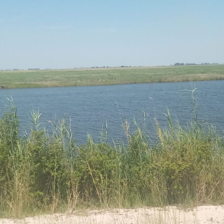
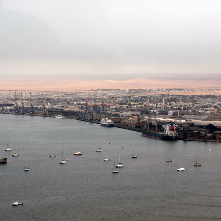
Walvis Bay is a deep-water port in western Namibia, where its lagoon covers approximately 12,000 acres (4,900 hectares) and supports populations of flamingos, pelicans, and other seabirds. The shallow waters of this lagoon attract both resident and migratory bird species, forming an important wetland along the Namibian coast. This port serves as an economic center for the region and provides access to maritime activities and bird observation opportunities. Walvis Bay complements exploration of Namibia's natural areas between the Namib Desert and the Atlantic Ocean, connecting coastal ecosystems with the arid interior landscapes.
Mangetti Park is a 420-square-kilometer (162-square-mile) protected area in the Kavango West Region that forms part of Namibia's natural landscapes. The park contains giraffes, kudus, and elands in an acacia savanna and contributes to the conservation of wildlife adapted to the conditions of northern Namibia. Mangetti Park complements the network of protected areas that preserve the flora and fauna of the country's arid and semi-arid regions, providing habitat for antelope species and other mammals in an area of acacia woodland and grassland.
The Brandberg is a granite massif rising to 2,573 meters (8,442 feet), making it the highest elevation in Namibia. This massif contains more than 45,000 Stone Age rock paintings, including the famous White Lady of Brandberg, which represent some of the most significant prehistoric art collections in southern Africa. These archaeological sites complement Namibia's natural and historical attractions such as Etosha National Park and the Twyfelfontein engravings by providing evidence of early human habitation in arid environments.
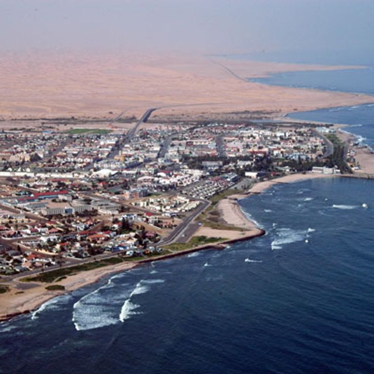
Swakopmund is a coastal town in the Erongo Region known for its German colonial architecture from the early twentieth century. This town features Art Nouveau and Wilhelmine-style buildings, including the Woermannhaus, the lighthouse, and the old magistrate's court. The structures reflect Namibia's colonial past and stand in contrast to the surrounding desert landscape. Swakopmund serves as a base for exploring the Skeleton Coast and the Namib Desert. The town combines colonial heritage with access to Namibia's natural sites, including dunes and coastal areas. The historic town center preserves examples of German colonial architecture in an African coastal setting.
Okonjima is a 77-square-mile (200 square kilometers) conservation area in Otjozondjupa Region dedicated to the protection of cheetahs and leopards. The AfriCat Foundation operates research and protection programs for big cats in their natural habitat at this location. The reserve provides insight into conservation efforts for endangered predator species and their rehabilitation. The facility documents the behavior and population dynamics of these animals in the Namibian wilderness.
This desert valley in the Namib Desert contains distinctive ochre sand dunes that rise to approximately 1,000 feet (300 meters). The terrain forms part of one of Earth's oldest arid zones and presents a contrast between reddish dune formations and white salt pans at the valley floor. Sossusvlei ranks among Namibia's most recognized geological formations and demonstrates the extreme conditions under which desert landscapes develop over millions of years. The formation lies within Namib-Naukluft Park and represents typical features of the Namib Desert with its dune fields and dry vegetation.
This canyon ranks among the most significant natural formations in Namibia. Fish River Canyon extends 100 miles (160 kilometers) in length and reaches a depth of 1,800 feet (550 meters). The Fish River, which flows through the formation, carries water only during certain seasons. The gorge provides insight into geological processes that developed over millions of years and demonstrates the adaptability of flora and fauna to arid conditions. Trails along the canyon rim and through the riverbed enable exploration of this natural landscape.
This national park covers more than 8,500 square miles (22,000 square kilometers) in northern Namibia, protecting diverse ecosystems around the expansive Etosha salt pan. The park's waterholes attract large herds of elephants, zebras, wildebeest, and various antelope species during the dry season. Lions, leopards, cheetahs, and hyenas inhabit this area. More than 340 bird species have been recorded here, including ostriches and various raptors. The salt pan itself covers approximately 1,850 square miles (4,800 square kilometers) and occasionally fills with water after heavy rains, drawing flamingos and other water birds. Several camps within the park provide access to observation points and floodlit waterholes for nighttime wildlife viewing.
This former diamond mining town was established in 1908 during the diamond rush in the Namib Desert. Kolmanskop grew rapidly into a prosperous settlement with German colonial architecture, including residential buildings, a hospital, a school, and a casino. After diamond deposits declined in the 1930s, the town was abandoned. Today, sand dunes invade the empty structures, creating a landscape that demonstrates the contrast between human settlement and the power of the desert.
This park covers 49,768 square kilometers (19,216 square miles) and is the largest conservation area in Namibia. It combines the Namib Desert with the Naukluft Mountains and provides habitat for oryx and zebras. As part of Namibia's desert landscapes, Namib-Naukluft Park complements the country's natural sites, which include the red dunes of Sossusvlei and other nature reserves hosting wildlife and flora adapted to dry conditions.
This sandy peninsula on the coast of Walvis Bay is home to a historic lighthouse built in 1932 and one of the largest colonies of Cape fur seals in Namibia. The peninsula extends 7 miles (11 kilometers) into the bay and provides habitat for several thousand seals that gather on the sandbanks and shoreline. The red and white striped lighthouse continues to serve navigation for vessels approaching Walvis Bay harbor. The shallow waters and lagoons surrounding Pelican Point attract pelicans, flamingos, and other coastal birds. The peninsula is accessible only by a long sandy track or by boat and lies within the boundaries of the Walvis Bay Lagoon Ramsar wetland site.
This coastal region extends over 300 miles (500 kilometers) along the Atlantic and is part of the collection of Namibia's natural and historical sites. The Skeleton Coast displays numerous shipwrecks that lie on the beaches, remains of vessels that ran aground in the foggy and dangerous waters. The protected coastal zone hosts large seal colonies that have settled at several locations along the shore. This region lies in the northern part of the country and connects the Namib Desert with the ocean, where cool ocean currents and dry desert climate meet.
Sandwich Harbour is a saltwater lagoon in the Erongo Region where a peninsula meets the high sand dunes of the Namib Desert and the Atlantic Ocean. This site provides habitat for flamingos, pelicans, and other waterbirds that feed in the shallow waters. The dunes reach heights of up to 330 feet (100 meters) and extend to the sea. The area is accessible only by four-wheel-drive vehicles at low tide. This lagoon complements the understanding of Namibia's coastal ecosystems along the Namib Desert.
This archaeological site contains over 2500 rock engravings dating back 6000 years, depicting animals such as giraffes, elephants, rhinoceroses, and antelopes, along with geometric figures. Twyfelfontein is located in the Kunene Region and represents one of the most important concentrations of prehistoric art in southern Africa. The engravings were created by San peoples who carved the images into red sandstone, documenting their way of life and spiritual beliefs. This site adds a significant cultural dimension to Namibia's natural and historical attractions like Etosha and Sossusvlei.
This marine reserve hosts one of the largest Cape fur seal colonies along the Namibian coast, with more than 100,000 animals inhabiting and breeding at this protected coastal location. The seal colony provides visitors with opportunities to observe the behavior of these marine mammals in their natural environment. A stone cross erected in 1486 by Portuguese navigator Diogo Cão stands at the site, representing one of the oldest European monuments in southern Africa. This combination of wildlife and history makes Cape Cross a notable point among Namibia's natural and historical attractions.
This city serves as the administrative and economic center of Namibia and sits at an elevation of 5,577 feet (1,700 meters). Windhoek houses major government institutions including Parliament, the Supreme Court, and the Central Bank. As the national capital, the city functions as a gateway for visitors exploring Namibia's principal natural sites and historical locations, from Etosha National Park and the Sossusvlei dunes to the coastal town of Swakopmund.
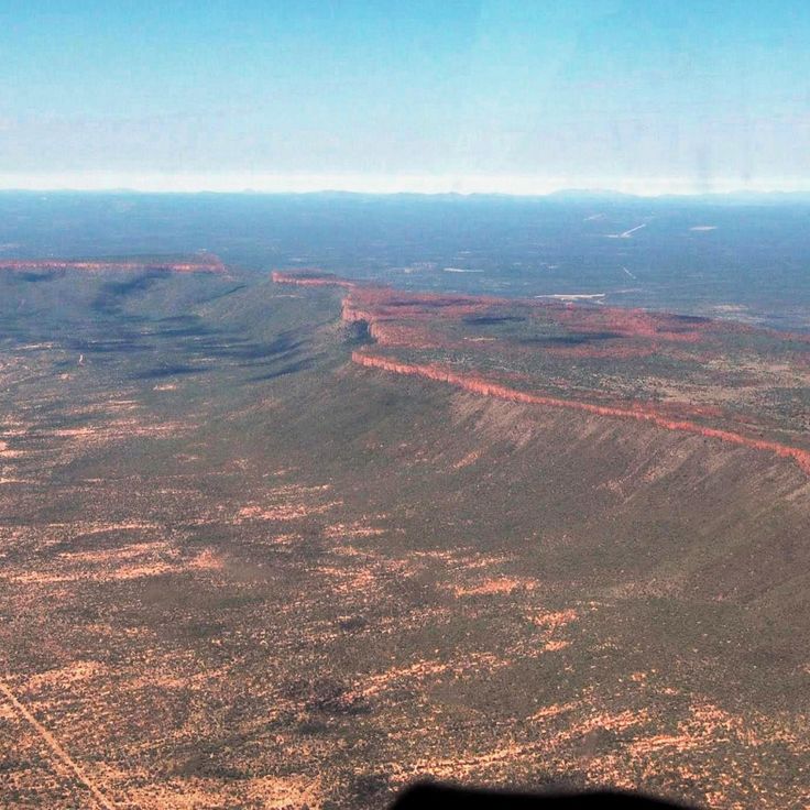
The Waterberg Plateau rises approximately 650 feet (200 meters) above the surrounding plains of the Otjozondjupa Region, forming a distinctive sandstone massif. This plateau is part of Namibia's network of protected areas and provides habitat for endangered species including black rhinoceroses and various antelope species. The vegetation on the plateau differs markedly from the arid surroundings, benefiting from higher rainfall. The area plays an important role in Namibia's conservation efforts and complements other significant natural sites such as Etosha National Park and the Namib Desert.
Deadvlei is a white clay basin in Namib-Naukluft National Park, surrounded by orange dunes reaching up to 1,000 feet (300 meters). The black acacia trunks in this basin died roughly 900 years ago when the Tsauchab River changed course and the trees withered. The dry desert air preserved the dead trees, which could not decompose due to lack of moisture. Deadvlei sits about 1.2 miles (2 kilometers) from Sossusvlei and represents one of the photographed landscapes in Namibia.
Spitzkoppe rises 2,297 feet (700 meters) above the Namib Desert and consists of granite formations that formed over 120 million years ago. This rock formation displays ancient San rock paintings dating back up to 4,000 years. Spitzkoppe is often called the Matterhorn of Namibia due to its pointed shape and offers climbing routes and hiking trails through the granite landscape. The area represents one of Namibia's geological features and complements the natural landscapes of Etosha National Park, Sossusvlei, and Fish River Canyon.
The Epupa Falls represent one of northern Namibia's significant natural features along the Kunene River, which forms the border with Angola. These waterfalls extend for 0.9 miles (1.5 kilometers) and reach a maximum height of 120 feet (37 meters). The water cascades over multiple drops into deep pools, surrounded by fan palms and baobab trees. The Epupa Falls lie within Himba territory, whose traditional settlements are found in this region, and offer insight into the adaptation of life and culture to the harsh conditions of northwestern Namibia.
Bwabwata Park covers 6,100 square miles (15,800 square kilometers) between the Okavango and Kwando Rivers and provides habitat for elephants, buffaloes, and antelopes. This protected area in the Zambezi Region forms an important wildlife corridor connecting Angola, Botswana, Zambia, and Zimbabwe. The park supports various antelope species and large mammals adapted to arid conditions, complementing Namibia's network of nature reserves and national parks that protect wildlife and flora across the country's diverse landscapes.
The Caprivi Strip is a narrow corridor of land in northeastern Namibia extending between Botswana to the south, Angola to the north, and Zambia to the east. This region encompasses several national parks and conservation areas, including Bwabwata, Mudumu, and Nkasa Rupara, known for their elephant populations and water-rich landscape. The area differs notably from the rest of arid Namibia through its rivers and wetlands, providing habitat for diverse wildlife. The Caprivi Strip was officially renamed Zambezi Region in 2013.
This nature reserve spans 3950 hectares (9760 acres) in the Khomas Highlands and serves as an accessible wildlife refuge near Windhoek. Daan Viljoen hosts populations of mountain zebras, kudus, oryx, and wildebeest, along with a substantial bird population of more than 200 recorded species. The reserve features hiking trails that traverse hilly terrain covered with acacia and aloe vegetation. Located 15 miles (24 kilometers) west of the capital, it functions as a frequently visited destination for day trips and weekend stays. Established in 1962, this protected area plays an important role in wildlife conservation in central Namibia.
This canyon was carved by the Tsauchab River over millions of years through 30 feet (9 meters) of sedimentary rock layers and extends for about two thirds of a mile (1 kilometer) through the Namib Desert. Sesriem Canyon displays various rock strata that provide insights into geological processes and climatic changes in the region. The canyon serves as an access point to the dunes of Sossusvlei and offers visitors opportunities to explore Namibia's geological formations in an area where water flow represents a rare but defining force in the desert landscape.
Naankuse is a 22,240-acre (9,000-hectare) nature reserve focused on the research and rehabilitation of cheetahs and other large carnivores. This facility contributes to understanding Namibia's wildlife and provides programs for reintroducing threatened species to their natural habitats. Located in the Khomas Region, the reserve complements the country's nature reserves and national parks through its work with mammals adapted to arid conditions. Visitors can learn about ongoing conservation efforts for Namibia's fauna and the challenges of human-wildlife coexistence in semiarid landscapes.
This national park extends 200 miles (320 kilometers) along the Atlantic coast, connecting beaches, desert landscapes, and marine conservation zones. Dorob Park protects the transition zone between the Namib Desert and the ocean, hosting seal colonies, seabirds, and desert organisms adapted to extreme aridity. The park lies between Skeleton Coast National Park to the north and Namib-Naukluft Park to the south, contributing to the preservation of Namibia's natural coastal ecosystems featured in this collection.
This dune is a prominent sand formation in the Namib Desert, rising 383 feet (117 meters) high and ranking among the tallest dunes in Africa. The red color of the sand results from iron oxide formed through weathering processes. Dune 7 sits on the outskirts of Walvis Bay and offers visitors the opportunity to climb the steep slope and view the desert landscape. Access is provided via a paved road. This formation is among the notable geological features that characterize Namibia's desert regions, which also include the red dunes of Sossusvlei and other natural sites such as Etosha National Park.
This national park in southern Namibia encompasses a former diamond mining area that was closed to the public for over a century. The Sperrgebiet extends along the Atlantic coast and now protects the distinctive desert flora of the Namib, including numerous endemic plant species adapted to extreme arid conditions. The area also preserves historic mining installations and abandoned settlements from the colonial era. Visits are permitted only through guided tours that provide insights into the natural history and mining past of the region.
This remote mountainous region in northwestern Namibia constitutes the traditional territory of the Himba people, a semi-nomadic ethnic group who maintain their ancestral customs and way of life. Kaokoland extends across approximately 19,300 square miles (50,000 square kilometers) of arid, rocky terrain characterized by rugged mountains, deep valleys, and seasonal rivers. The area supports populations of desert-adapted elephants that traverse the riverbeds, along with giraffes, springbok, and oryx. Himba communities live in scattered settlements and practice pastoralism, with cattle holding central importance to their culture. The region ranks among Namibia's most sparsely populated areas and preserves an isolated wilderness with minimal modern development.
This 3,842 square kilometer (1,483 square mile) protected area lies in northeastern Namibia along the border with Botswana. The region enables free movement of elephants, lions, leopards, and other large mammals between both countries. Khaudom Park forms part of Namibia's network of natural reserves that preserve habitats adapted to the arid conditions of the Kalahari Desert. Vegetation consists of acacia and mopane woodlands along with open savannas that attract wildlife during rainy seasons. The area provides access to remote wilderness with minimal tourism infrastructure.
Nkasa Rupara Park protects 320 square kilometers (124 square miles) of wetland in Namibia's Zambezi Region, comprising two islands within the Kwando-Linyanti river system. This nature reserve provides habitat for hippopotamuses, crocodiles, and other species adapted to aquatic environments. The floodplains contrast with the arid landscapes that characterize much of Namibia, supporting waterbirds and large mammals. The park complements Namibia's network of protected areas with its focus on wetland ecosystems.
This viewing site on the northern rim of the Fish River Canyon provides access to hiking trails in the world's second-largest canyon. The station is located within a protected zone and serves as the starting point for the multi-day hike through the 100 mile (160 kilometer) long and up to 17 mile (27 kilometer) wide gorge. Hobas marks the entry to one of Namibia's most significant geological formations, where the Fish River has cut deep into the rock and created a landscape of rugged cliff faces and dry riverbeds.
Namib-Rand Park covers 200000 acres (about 80940 hectares) in southwestern Namibia between the red dunes of the Namib Desert and the Naukluft Mountains. This private nature reserve protects diverse desert ecosystems and provides habitat for species adapted to arid conditions, including oryx, springbok, and mountain zebra. The reserve borders Namib-Naukluft National Park, extending wildlife protection across this part of Namibia. The landscape includes sand dunes, mountain ranges, grass plains, and geological formations that illustrate the region's desert environment.
Walvis Bay is a deep-water port in western Namibia, where its lagoon covers approximately 12,000 acres (4,900 hectares) and supports populations of flamingos, pelicans, and other seabirds. The shallow waters of this lagoon attract both resident and migratory bird species, forming an important wetland along the Namibian coast. This port serves as an economic center for the region and provides access to maritime activities and bird observation opportunities. Walvis Bay complements exploration of Namibia's natural areas between the Namib Desert and the Atlantic Ocean, connecting coastal ecosystems with the arid interior landscapes.
Mangetti Park is a 420-square-kilometer (162-square-mile) protected area in the Kavango West Region that forms part of Namibia's natural landscapes. The park contains giraffes, kudus, and elands in an acacia savanna and contributes to the conservation of wildlife adapted to the conditions of northern Namibia. Mangetti Park complements the network of protected areas that preserve the flora and fauna of the country's arid and semi-arid regions, providing habitat for antelope species and other mammals in an area of acacia woodland and grassland.
The Brandberg is a granite massif rising to 2,573 meters (8,442 feet), making it the highest elevation in Namibia. This massif contains more than 45,000 Stone Age rock paintings, including the famous White Lady of Brandberg, which represent some of the most significant prehistoric art collections in southern Africa. These archaeological sites complement Namibia's natural and historical attractions such as Etosha National Park and the Twyfelfontein engravings by providing evidence of early human habitation in arid environments.
Swakopmund is a coastal town in the Erongo Region known for its German colonial architecture from the early twentieth century. This town features Art Nouveau and Wilhelmine-style buildings, including the Woermannhaus, the lighthouse, and the old magistrate's court. The structures reflect Namibia's colonial past and stand in contrast to the surrounding desert landscape. Swakopmund serves as a base for exploring the Skeleton Coast and the Namib Desert. The town combines colonial heritage with access to Namibia's natural sites, including dunes and coastal areas. The historic town center preserves examples of German colonial architecture in an African coastal setting.
Okonjima is a 77-square-mile (200 square kilometers) conservation area in Otjozondjupa Region dedicated to the protection of cheetahs and leopards. The AfriCat Foundation operates research and protection programs for big cats in their natural habitat at this location. The reserve provides insight into conservation efforts for endangered predator species and their rehabilitation. The facility documents the behavior and population dynamics of these animals in the Namibian wilderness.
This desert valley in the Namib Desert contains distinctive ochre sand dunes that rise to approximately 1,000 feet (300 meters). The terrain forms part of one of Earth's oldest arid zones and presents a contrast between reddish dune formations and white salt pans at the valley floor. Sossusvlei ranks among Namibia's most recognized geological formations and demonstrates the extreme conditions under which desert landscapes develop over millions of years. The formation lies within Namib-Naukluft Park and represents typical features of the Namib Desert with its dune fields and dry vegetation.
This canyon ranks among the most significant natural formations in Namibia. Fish River Canyon extends 100 miles (160 kilometers) in length and reaches a depth of 1,800 feet (550 meters). The Fish River, which flows through the formation, carries water only during certain seasons. The gorge provides insight into geological processes that developed over millions of years and demonstrates the adaptability of flora and fauna to arid conditions. Trails along the canyon rim and through the riverbed enable exploration of this natural landscape.
This national park covers more than 8,500 square miles (22,000 square kilometers) in northern Namibia, protecting diverse ecosystems around the expansive Etosha salt pan. The park's waterholes attract large herds of elephants, zebras, wildebeest, and various antelope species during the dry season. Lions, leopards, cheetahs, and hyenas inhabit this area. More than 340 bird species have been recorded here, including ostriches and various raptors. The salt pan itself covers approximately 1,850 square miles (4,800 square kilometers) and occasionally fills with water after heavy rains, drawing flamingos and other water birds. Several camps within the park provide access to observation points and floodlit waterholes for nighttime wildlife viewing.
This former diamond mining town was established in 1908 during the diamond rush in the Namib Desert. Kolmanskop grew rapidly into a prosperous settlement with German colonial architecture, including residential buildings, a hospital, a school, and a casino. After diamond deposits declined in the 1930s, the town was abandoned. Today, sand dunes invade the empty structures, creating a landscape that demonstrates the contrast between human settlement and the power of the desert.
This park covers 49,768 square kilometers (19,216 square miles) and is the largest conservation area in Namibia. It combines the Namib Desert with the Naukluft Mountains and provides habitat for oryx and zebras. As part of Namibia's desert landscapes, Namib-Naukluft Park complements the country's natural sites, which include the red dunes of Sossusvlei and other nature reserves hosting wildlife and flora adapted to dry conditions.
This sandy peninsula on the coast of Walvis Bay is home to a historic lighthouse built in 1932 and one of the largest colonies of Cape fur seals in Namibia. The peninsula extends 7 miles (11 kilometers) into the bay and provides habitat for several thousand seals that gather on the sandbanks and shoreline. The red and white striped lighthouse continues to serve navigation for vessels approaching Walvis Bay harbor. The shallow waters and lagoons surrounding Pelican Point attract pelicans, flamingos, and other coastal birds. The peninsula is accessible only by a long sandy track or by boat and lies within the boundaries of the Walvis Bay Lagoon Ramsar wetland site.
This coastal region extends over 300 miles (500 kilometers) along the Atlantic and is part of the collection of Namibia's natural and historical sites. The Skeleton Coast displays numerous shipwrecks that lie on the beaches, remains of vessels that ran aground in the foggy and dangerous waters. The protected coastal zone hosts large seal colonies that have settled at several locations along the shore. This region lies in the northern part of the country and connects the Namib Desert with the ocean, where cool ocean currents and dry desert climate meet.
Sandwich Harbour is a saltwater lagoon in the Erongo Region where a peninsula meets the high sand dunes of the Namib Desert and the Atlantic Ocean. This site provides habitat for flamingos, pelicans, and other waterbirds that feed in the shallow waters. The dunes reach heights of up to 330 feet (100 meters) and extend to the sea. The area is accessible only by four-wheel-drive vehicles at low tide. This lagoon complements the understanding of Namibia's coastal ecosystems along the Namib Desert.
This archaeological site contains over 2500 rock engravings dating back 6000 years, depicting animals such as giraffes, elephants, rhinoceroses, and antelopes, along with geometric figures. Twyfelfontein is located in the Kunene Region and represents one of the most important concentrations of prehistoric art in southern Africa. The engravings were created by San peoples who carved the images into red sandstone, documenting their way of life and spiritual beliefs. This site adds a significant cultural dimension to Namibia's natural and historical attractions like Etosha and Sossusvlei.
This marine reserve hosts one of the largest Cape fur seal colonies along the Namibian coast, with more than 100,000 animals inhabiting and breeding at this protected coastal location. The seal colony provides visitors with opportunities to observe the behavior of these marine mammals in their natural environment. A stone cross erected in 1486 by Portuguese navigator Diogo Cão stands at the site, representing one of the oldest European monuments in southern Africa. This combination of wildlife and history makes Cape Cross a notable point among Namibia's natural and historical attractions.
This city serves as the administrative and economic center of Namibia and sits at an elevation of 5,577 feet (1,700 meters). Windhoek houses major government institutions including Parliament, the Supreme Court, and the Central Bank. As the national capital, the city functions as a gateway for visitors exploring Namibia's principal natural sites and historical locations, from Etosha National Park and the Sossusvlei dunes to the coastal town of Swakopmund.
The Waterberg Plateau rises approximately 650 feet (200 meters) above the surrounding plains of the Otjozondjupa Region, forming a distinctive sandstone massif. This plateau is part of Namibia's network of protected areas and provides habitat for endangered species including black rhinoceroses and various antelope species. The vegetation on the plateau differs markedly from the arid surroundings, benefiting from higher rainfall. The area plays an important role in Namibia's conservation efforts and complements other significant natural sites such as Etosha National Park and the Namib Desert.
Deadvlei is a white clay basin in Namib-Naukluft National Park, surrounded by orange dunes reaching up to 1,000 feet (300 meters). The black acacia trunks in this basin died roughly 900 years ago when the Tsauchab River changed course and the trees withered. The dry desert air preserved the dead trees, which could not decompose due to lack of moisture. Deadvlei sits about 1.2 miles (2 kilometers) from Sossusvlei and represents one of the photographed landscapes in Namibia.
Spitzkoppe rises 2,297 feet (700 meters) above the Namib Desert and consists of granite formations that formed over 120 million years ago. This rock formation displays ancient San rock paintings dating back up to 4,000 years. Spitzkoppe is often called the Matterhorn of Namibia due to its pointed shape and offers climbing routes and hiking trails through the granite landscape. The area represents one of Namibia's geological features and complements the natural landscapes of Etosha National Park, Sossusvlei, and Fish River Canyon.
The Epupa Falls represent one of northern Namibia's significant natural features along the Kunene River, which forms the border with Angola. These waterfalls extend for 0.9 miles (1.5 kilometers) and reach a maximum height of 120 feet (37 meters). The water cascades over multiple drops into deep pools, surrounded by fan palms and baobab trees. The Epupa Falls lie within Himba territory, whose traditional settlements are found in this region, and offer insight into the adaptation of life and culture to the harsh conditions of northwestern Namibia.
Bwabwata Park covers 6,100 square miles (15,800 square kilometers) between the Okavango and Kwando Rivers and provides habitat for elephants, buffaloes, and antelopes. This protected area in the Zambezi Region forms an important wildlife corridor connecting Angola, Botswana, Zambia, and Zimbabwe. The park supports various antelope species and large mammals adapted to arid conditions, complementing Namibia's network of nature reserves and national parks that protect wildlife and flora across the country's diverse landscapes.
The Caprivi Strip is a narrow corridor of land in northeastern Namibia extending between Botswana to the south, Angola to the north, and Zambia to the east. This region encompasses several national parks and conservation areas, including Bwabwata, Mudumu, and Nkasa Rupara, known for their elephant populations and water-rich landscape. The area differs notably from the rest of arid Namibia through its rivers and wetlands, providing habitat for diverse wildlife. The Caprivi Strip was officially renamed Zambezi Region in 2013.
This nature reserve spans 3950 hectares (9760 acres) in the Khomas Highlands and serves as an accessible wildlife refuge near Windhoek. Daan Viljoen hosts populations of mountain zebras, kudus, oryx, and wildebeest, along with a substantial bird population of more than 200 recorded species. The reserve features hiking trails that traverse hilly terrain covered with acacia and aloe vegetation. Located 15 miles (24 kilometers) west of the capital, it functions as a frequently visited destination for day trips and weekend stays. Established in 1962, this protected area plays an important role in wildlife conservation in central Namibia.
This canyon was carved by the Tsauchab River over millions of years through 30 feet (9 meters) of sedimentary rock layers and extends for about two thirds of a mile (1 kilometer) through the Namib Desert. Sesriem Canyon displays various rock strata that provide insights into geological processes and climatic changes in the region. The canyon serves as an access point to the dunes of Sossusvlei and offers visitors opportunities to explore Namibia's geological formations in an area where water flow represents a rare but defining force in the desert landscape.
Naankuse is a 22,240-acre (9,000-hectare) nature reserve focused on the research and rehabilitation of cheetahs and other large carnivores. This facility contributes to understanding Namibia's wildlife and provides programs for reintroducing threatened species to their natural habitats. Located in the Khomas Region, the reserve complements the country's nature reserves and national parks through its work with mammals adapted to arid conditions. Visitors can learn about ongoing conservation efforts for Namibia's fauna and the challenges of human-wildlife coexistence in semiarid landscapes.
This national park extends 200 miles (320 kilometers) along the Atlantic coast, connecting beaches, desert landscapes, and marine conservation zones. Dorob Park protects the transition zone between the Namib Desert and the ocean, hosting seal colonies, seabirds, and desert organisms adapted to extreme aridity. The park lies between Skeleton Coast National Park to the north and Namib-Naukluft Park to the south, contributing to the preservation of Namibia's natural coastal ecosystems featured in this collection.
This dune is a prominent sand formation in the Namib Desert, rising 383 feet (117 meters) high and ranking among the tallest dunes in Africa. The red color of the sand results from iron oxide formed through weathering processes. Dune 7 sits on the outskirts of Walvis Bay and offers visitors the opportunity to climb the steep slope and view the desert landscape. Access is provided via a paved road. This formation is among the notable geological features that characterize Namibia's desert regions, which also include the red dunes of Sossusvlei and other natural sites such as Etosha National Park.
This national park in southern Namibia encompasses a former diamond mining area that was closed to the public for over a century. The Sperrgebiet extends along the Atlantic coast and now protects the distinctive desert flora of the Namib, including numerous endemic plant species adapted to extreme arid conditions. The area also preserves historic mining installations and abandoned settlements from the colonial era. Visits are permitted only through guided tours that provide insights into the natural history and mining past of the region.
This remote mountainous region in northwestern Namibia constitutes the traditional territory of the Himba people, a semi-nomadic ethnic group who maintain their ancestral customs and way of life. Kaokoland extends across approximately 19,300 square miles (50,000 square kilometers) of arid, rocky terrain characterized by rugged mountains, deep valleys, and seasonal rivers. The area supports populations of desert-adapted elephants that traverse the riverbeds, along with giraffes, springbok, and oryx. Himba communities live in scattered settlements and practice pastoralism, with cattle holding central importance to their culture. The region ranks among Namibia's most sparsely populated areas and preserves an isolated wilderness with minimal modern development.
This 3,842 square kilometer (1,483 square mile) protected area lies in northeastern Namibia along the border with Botswana. The region enables free movement of elephants, lions, leopards, and other large mammals between both countries. Khaudom Park forms part of Namibia's network of natural reserves that preserve habitats adapted to the arid conditions of the Kalahari Desert. Vegetation consists of acacia and mopane woodlands along with open savannas that attract wildlife during rainy seasons. The area provides access to remote wilderness with minimal tourism infrastructure.
Nkasa Rupara Park protects 320 square kilometers (124 square miles) of wetland in Namibia's Zambezi Region, comprising two islands within the Kwando-Linyanti river system. This nature reserve provides habitat for hippopotamuses, crocodiles, and other species adapted to aquatic environments. The floodplains contrast with the arid landscapes that characterize much of Namibia, supporting waterbirds and large mammals. The park complements Namibia's network of protected areas with its focus on wetland ecosystems.
This viewing site on the northern rim of the Fish River Canyon provides access to hiking trails in the world's second-largest canyon. The station is located within a protected zone and serves as the starting point for the multi-day hike through the 100 mile (160 kilometer) long and up to 17 mile (27 kilometer) wide gorge. Hobas marks the entry to one of Namibia's most significant geological formations, where the Fish River has cut deep into the rock and created a landscape of rugged cliff faces and dry riverbeds.
Namib-Rand Park covers 200000 acres (about 80940 hectares) in southwestern Namibia between the red dunes of the Namib Desert and the Naukluft Mountains. This private nature reserve protects diverse desert ecosystems and provides habitat for species adapted to arid conditions, including oryx, springbok, and mountain zebra. The reserve borders Namib-Naukluft National Park, extending wildlife protection across this part of Namibia. The landscape includes sand dunes, mountain ranges, grass plains, and geological formations that illustrate the region's desert environment.
Walvis Bay is a deep-water port in western Namibia, where its lagoon covers approximately 12,000 acres (4,900 hectares) and supports populations of flamingos, pelicans, and other seabirds. The shallow waters of this lagoon attract both resident and migratory bird species, forming an important wetland along the Namibian coast. This port serves as an economic center for the region and provides access to maritime activities and bird observation opportunities. Walvis Bay complements exploration of Namibia's natural areas between the Namib Desert and the Atlantic Ocean, connecting coastal ecosystems with the arid interior landscapes.
Mangetti Park is a 420-square-kilometer (162-square-mile) protected area in the Kavango West Region that forms part of Namibia's natural landscapes. The park contains giraffes, kudus, and elands in an acacia savanna and contributes to the conservation of wildlife adapted to the conditions of northern Namibia. Mangetti Park complements the network of protected areas that preserve the flora and fauna of the country's arid and semi-arid regions, providing habitat for antelope species and other mammals in an area of acacia woodland and grassland.
The Brandberg is a granite massif rising to 2,573 meters (8,442 feet), making it the highest elevation in Namibia. This massif contains more than 45,000 Stone Age rock paintings, including the famous White Lady of Brandberg, which represent some of the most significant prehistoric art collections in southern Africa. These archaeological sites complement Namibia's natural and historical attractions such as Etosha National Park and the Twyfelfontein engravings by providing evidence of early human habitation in arid environments.
Swakopmund is a coastal town in the Erongo Region known for its German colonial architecture from the early twentieth century. This town features Art Nouveau and Wilhelmine-style buildings, including the Woermannhaus, the lighthouse, and the old magistrate's court. The structures reflect Namibia's colonial past and stand in contrast to the surrounding desert landscape. Swakopmund serves as a base for exploring the Skeleton Coast and the Namib Desert. The town combines colonial heritage with access to Namibia's natural sites, including dunes and coastal areas. The historic town center preserves examples of German colonial architecture in an African coastal setting.