See the monuments around you in AROpen chests in the app
Around Us is built for your phone — point your camera at the streets and discover the monuments and places around you in augmented reality.Around Us is built for your phone — chests unlock when you walk, explore and capture nearby places.
Australian outback: natural landmarks, geology, desert landscapes
The Australian outback encompasses a vast territory featuring distinctive geological characteristics, including ancient sandstone formations, deep canyons, and expansive salt lakes. This region contains some of Earth's oldest landscapes, from the red monoliths of the Northern Territory to the layered rock formations of Western Australia. Visitors can explore underground settlements created as shelter from extreme temperatures, as well as impact craters dating back millions of years.
The collection includes sites such as Uluru and Kata Tjuta in the Northern Territory, which represent massive red sandstone formations. Kings Canyon offers tall sandstone cliffs and gorges, while Purnululu National Park in Western Australia is known for its orange and black striped sandstone domes. Other notable locations include the Devils Marbles (Karlu Karlu), rounded granite boulders in the Northern Territory, and Wolfe Creek Crater, one of the world's largest meteorite craters. Karijini National Park displays deep gorges with layered rock, while Ningaloo Reef on the western coast hosts a coral reef system. The region also contains rainforest areas such as the Daintree Rainforest in Queensland and wilderness areas in Tasmania.
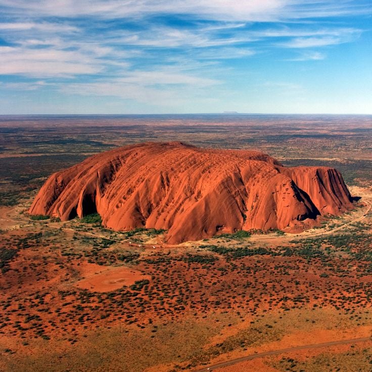
This red sandstone monolith rises 1142 feet (348 meters) above the plain in the Northern Territory. Uluru stands as one of the most recognizable geological formations in the Australian outback and holds considerable cultural importance for Aboriginal people. The rock displays varying shades of red depending on the time of day and weather conditions. The formation developed approximately 550 million years ago through geological processes. Uluru is surrounded by walking trails that provide insights into the geology and history of the region.
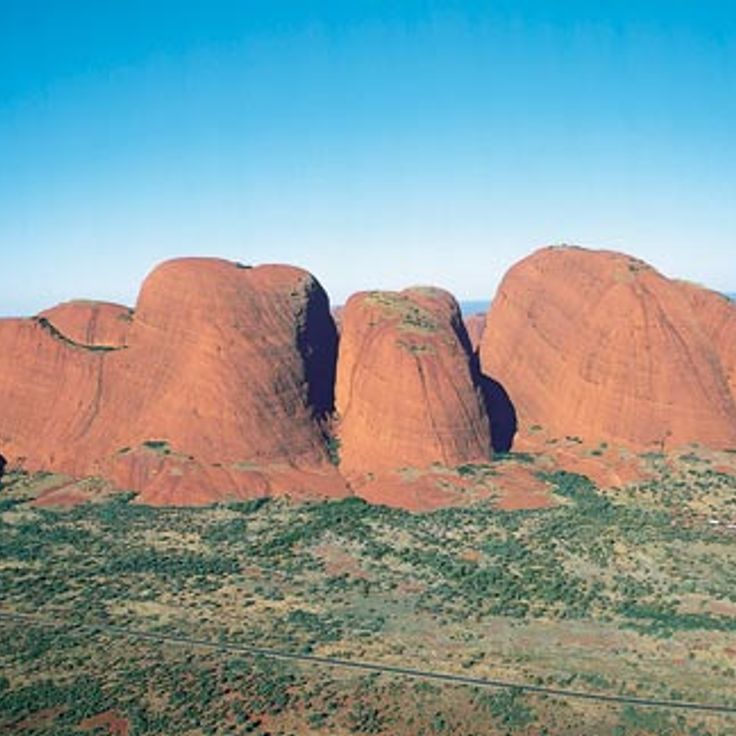
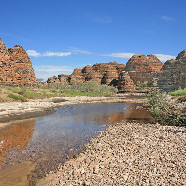
These 36 rounded red sandstone formations rise from the desert landscape of the Australian outback, reaching 546 feet (approximately 167 meters) at their highest point. Kata Tjuta forms part of the territory known for sandstone rocks, canyons, and geological features alongside nearby landmarks such as Uluru and Kings Canyon. The rock formations developed through millions of years of erosion and display deep valleys and gorges running between the individual domes. The area sits within a region that also encompasses underground settlements, meteor craters, and varied ecosystems ranging from rainforests to coral reefs.
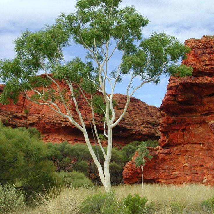
This sandstone canyon in Australia's Northern Territory reaches a depth of 890 feet (270 meters) and ranks among the significant geological formations of the Australian outback. The red rock walls of Kings Canyon contrast with green vegetation growing at the canyon floor. The formation developed over millions of years through erosion and displays various sandstone layers. The canyon is part of Watarrka National Park and offers insights into the geology of this region, which includes other sandstone structures like Uluru and Kata Tjuta among the continent's characteristic formations.
This national park in the Australian outback presents striped sandstone towers that rise up to 980 feet (300 meters). The orange and gray layers of Purnululu formed through weathering processes over millions of years. The formations are among the geological features of this region known for its sandstone structures, canyons, and expansive landscapes. The area displays the characteristic erosion patterns of the outback and provides insights into the geological history of Western Australia.
This site in the Australian outback consists of large granite rocks spread across 1800 hectares (4448 acres) in a flat landscape. The rock formations have developed through millions of years of erosion and now form one of the distinct geological features of the region. Devils Marbles (Karlu Karlu) is among the natural landmarks of the Northern Territory and demonstrates the geological processes that have shaped the Australian outback. The granite boulders lie scattered across the plain and form arrangements ranging from small stones to rocks several yards tall.
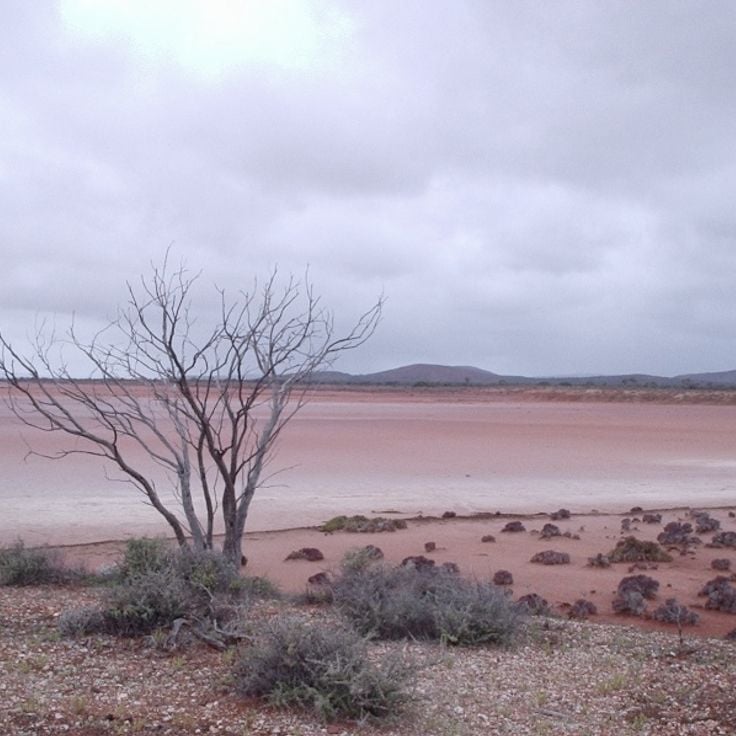
Lake Gairdner is a large salt lake in South Australia covering an area of approximately 1660 square miles (4300 square kilometers), representing one of the notable geological formations within the Australian outback. The salt surface of this lake provides a flat, hard expanse during dry periods that is regularly used for speed record attempts and motorsport events. The lake sits amid the arid landscape of the South Australian interior and occasionally forms a shallow body of water during rainy seasons before evaporating and leaving behind its characteristic salt crust. This natural landmark belongs to the group of ephemeral lakes in the region and serves as an example of the geological features that characterize the outback.
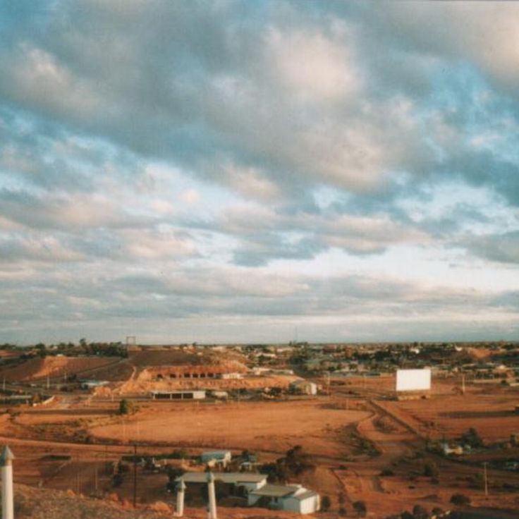
This town in the South Australian outback sits within a region containing over 250,000 mine shafts. Coober Pedy is known worldwide for its opal mining operations. Approximately 3,500 residents live in underground homes that protect them from extreme surface temperatures that can reach 122°F (50°C) in summer. The underground dwellings maintain consistent temperatures between 72 and 75°F (22 to 24°C) throughout the year. This settlement demonstrates human adaptation to Australian outback conditions through geological formations used for both mining and residential purposes.
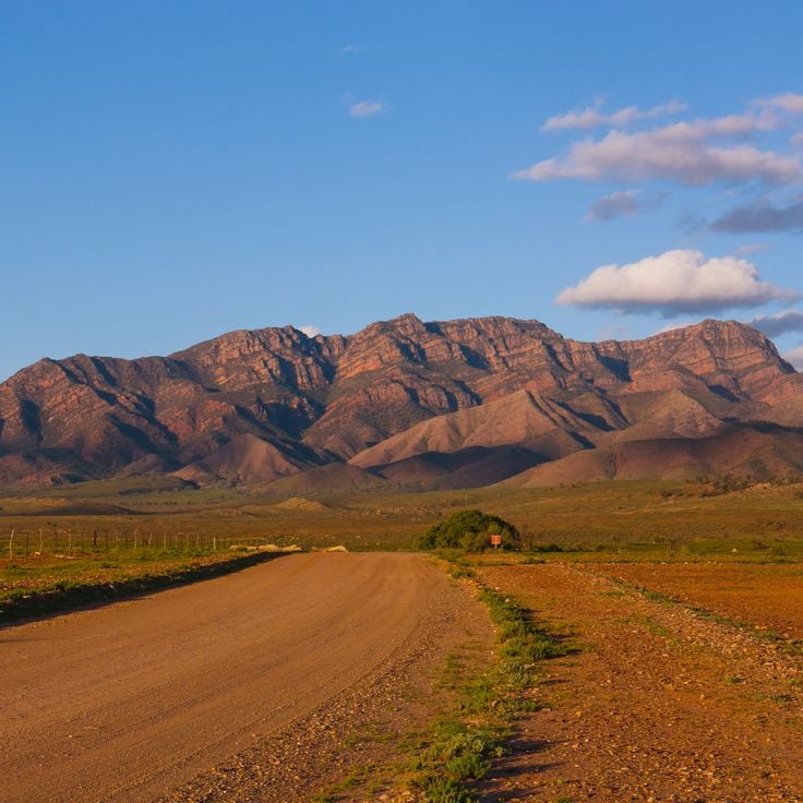
Wilpena Pound is a mountain basin in the Flinders Ranges National Park that extends for 11 miles (17 kilometers) in length and 5 miles (8 kilometers) in width. This natural depression formed through rock layers that folded and eroded over millions of years. The steep rock walls of the basin rise up to 1,600 feet (500 meters) above the valley floor and form a natural amphitheater. Like other geological formations in the Australian outback, Wilpena Pound displays the region's geological history through visible layers of sandstone and quartzite. The basin contains walking trails, historic Adnyamathanha sites, and vegetation adapted to the arid climate.
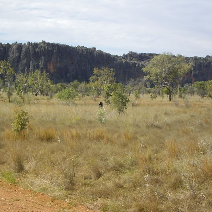
This mountain range in central Northern Territory extends for 400 miles (644 kilometers) and forms one of the most prominent landforms in the Australian outback. The MacDonnell Ranges contain deep gorges carved by millions of years of erosion, along with numerous Aboriginal rock paintings that hold cultural significance for the local Arrernte people. The range supports permanent waterholes, eucalyptus woodlands, and habitats for rock wallabies. The geological formations display folded quartzite ridges rising above the semiarid landscape.
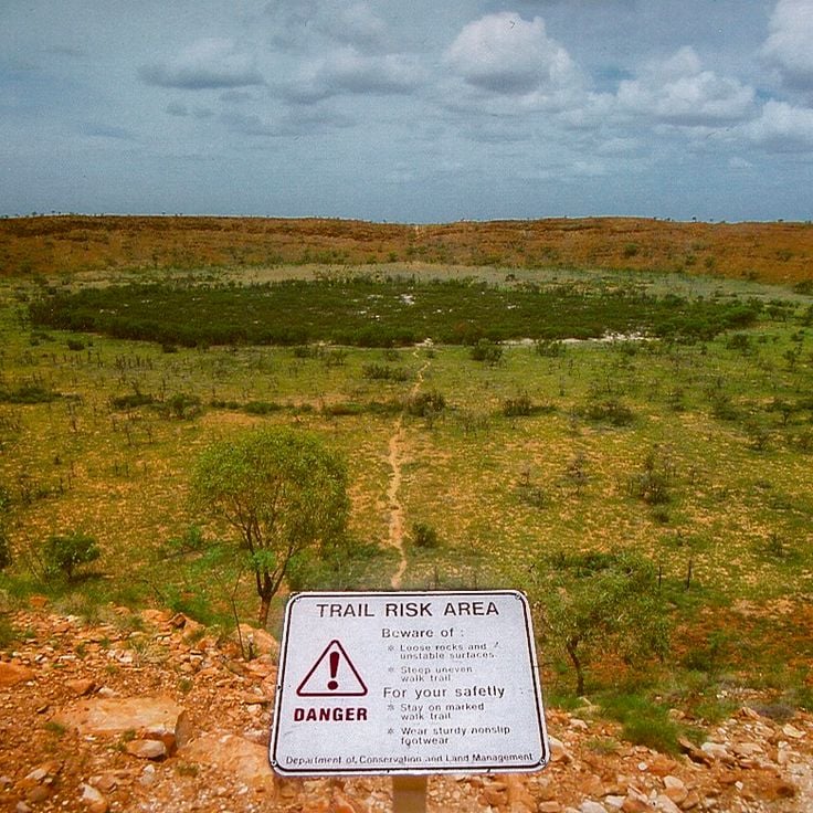
This meteorite crater measures 880 feet (268 meters) in diameter and formed approximately 300,000 years ago through the impact of a meteorite on the desert floor. Wolfe Creek Crater lies in a remote section of the Australian outback and represents one of the well-preserved impact structures of its kind worldwide. The crater rim rises roughly 82 feet (25 meters) above the surrounding plain and provides evidence of cosmic collisions with Earth's surface. This formation serves as a significant example of impact geology in the outback and documents the region's ancient history of meteorite activity.
This red sandstone monolith rises 3,629 feet (1,106 meters) above the territory and extends across a circumference of 30 miles (49 kilometers). Mount Augustus offers hiking trails along its base and to lookout points that provide access to geological formations and Aboriginal rock paintings. The formation developed approximately 1,650 million years ago and represents a larger monadnock than Uluru. The surroundings include gorges, seasonal waterholes, and vegetation characteristic of Australian outback wildlife.
This archaeological site in Mungo National Park contains human remains dated to 42,000 years ago and sand dunes preserving fossils and artifacts. The area documents the history of early settlement in Australia and displays geological formations from the last ice age. The lunette dunes preserve traces of ancient lakes and human activity. The park lies in the semi-arid zone of the Australian outback and forms part of the Willandra Lakes Region, recognized as a World Heritage site.
This sandstone formation in the expanse of the Australian outback rises 164 feet (50 meters) above the surrounding red sand dunes and has served as a navigation point for travelers for centuries. Chambers Pillar stands isolated in the desert landscape of the Northern Territory and displays distinct erosion patterns shaped by wind and water. The formation carries historical inscriptions from early European explorers and holds cultural significance for local Aboriginal communities. The area surrounding this geological feature consists of red sand, low scrub vegetation, and scattered rock formations typical of Australia's central desert region.
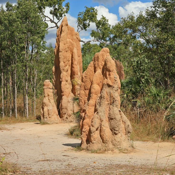
This park in the Northern Territory contains several waterfalls, including Wangi Falls, Florence Falls, and Tolmer Falls, which cascade into pools surrounded by monsoon rainforest. The natural swimming pools form within sandstone formations. The area displays magnetic termite mounds that reach up to 6 ft 7 in (2 meters) in height and align north to south due to the thermoregulatory orientation of compass termites. The park covers 580 square miles (1,500 square kilometers) and encompasses monsoon forests, eucalyptus woodland, and wetland areas. This reserve is located approximately 60 miles (100 kilometers) southwest of Darwin and documents geological formations of the Australian outback landscape.
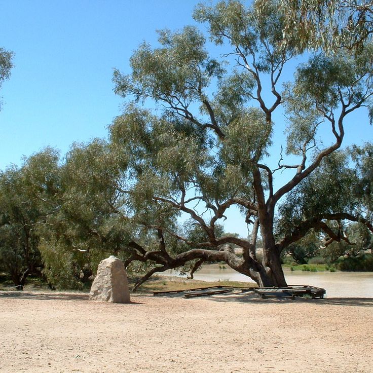
This eucalyptus tree bears historical carvings that mark the camp site of the Burke and Wills expedition of 1861. The tree served as a supply depot during one of the most significant exploration journeys across the Australian outback. The expedition attempted to traverse the Australian continent from south to north. At the Dig Tree, the support team buried provisions and messages for the returning explorers. The markings carved into the bark remain visible today and document a significant chapter in Australian exploration history. The site is located in a remote region of Queensland and provides insight into the challenges faced during early continental exploration. This landmark represents one of the geological and historical features found throughout the territory's natural landmarks.
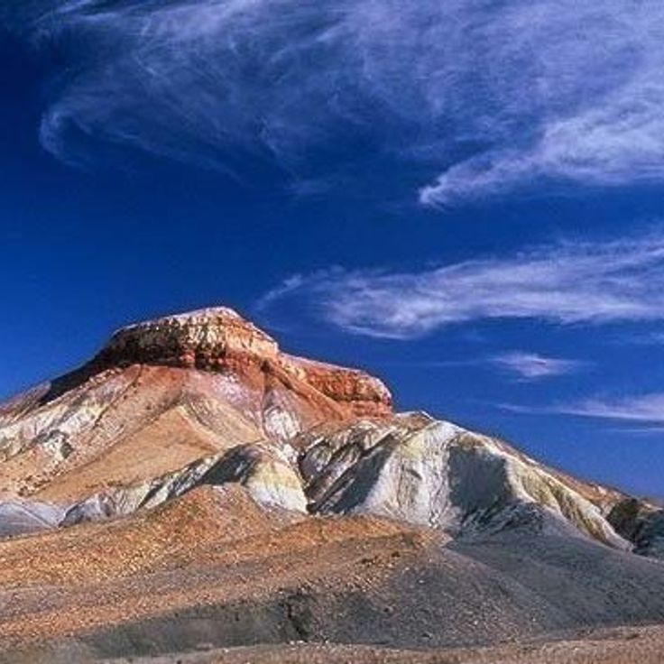
This desert landscape displays multicolored hills formed from sandstone, clay, and silt, colored by mineral deposits. The Painted Desert lies in the ranges south of the Flinders Ranges and forms part of the geological formations of the Australian outback. Rock strata span from the Cambrian to the Tertiary periods and include sediments deposited over millions of years. Iron oxides, manganese, and other minerals create color bands of red, orange, yellow, white, and purple across the eroded hills. This site demonstrates the geological diversity of the region alongside other natural landmarks such as Uluru and the Flinders Ranges.
These limestone caves formed during the Devonian period and create an underground system with chambers and passages. The Gooniyandi community guides visitors through the caves, which hold cultural significance in indigenous traditions and contain rock paintings as well as geological formations. Mimbi Caves is located in the Kimberley region and displays fossils from the time when the area was covered by a tropical reef. The caves contain stalactites, stalagmites, and underground pools formed through millions of years of geological processes.
This tropical rainforest is part of the Australian outback's geological diversity and houses 3000 plant species in a 180 million year old ecosystem. The Daintree Rainforest canopy reaches heights of 148 feet (45 meters) and forms a dense habitat for numerous endemic species. The forest extends across large areas and connects tropical vegetation with the natural landmarks of the region.
Karijini National Park is located in northwest Western Australia and displays some of the geological features of the outback. The park's gorges feature red rock walls reaching depths of up to 100 meters (328 feet), while several waterfalls flow into natural pools. These sandstone and iron ore formations represent an example of the canyons and water systems found in this remote region. The park is part of the larger territory that includes rock formations, waterfalls, and underground geological structures of the Australian outback.
The Cape York Peninsula covers 137,000 square miles (137,000 square kilometers) in the Australian outback and encompasses diverse ecosystems including monsoon forests, savannas, and mangrove swamps. This peninsula represents one of Australia's most sparsely populated regions with extensive wilderness areas. The territory forms the northernmost landmass of the Australian continent and borders the Torres Strait. The landscape displays geological formations that developed over millions of years, along with coastal areas adjacent to the region's coral reef systems.
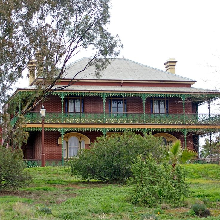
This Victorian mansion from 1885 documents paranormal reports and events spanning over a century. Monte Cristo Homestead offers night tours through the original preserved rooms where visitors learn about the property's history and documented supernatural phenomena. The building stands apart from the geological formations of the Australian outback, showing a different aspect of this region's history through its collection of historical artifacts and records of unexplained occurrences.
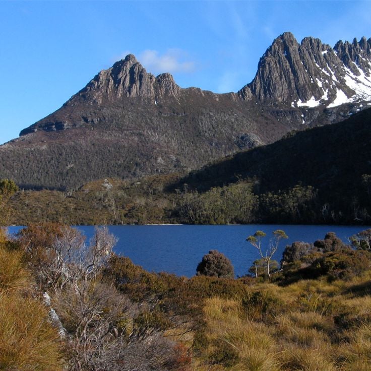
This protected area contains ancient rainforests and alpine regions. The reserve spans over one million acres (over 400,000 hectares) and houses numerous endemic plant and animal species. The Tasmanian Wilderness preserves Precambrian rock formations, glacial landscapes, and temperate rainforests that rank among Earth's oldest. The area contains limestone caves, moorland, and river valleys. The region serves as habitat for the Tasmanian devil and other native mammals. This protected area lies beyond the continental dry zones of Australia and forms a contrast to the sandstone formations and salt plains of the outback.
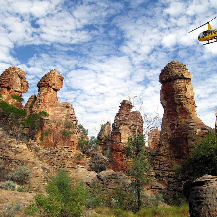
These natural rock formations in red sandstone within the Northern Territory create structures resembling urban buildings. Lost City lies in a remote desert region of the Australian outback and can only be accessed by four-wheel drive vehicles through unpaved tracks. The sandstone formations display erosion patterns that are part of the geological diversity of this region. The area sits far from paved roads and requires appropriate vehicles and preparation for visiting.
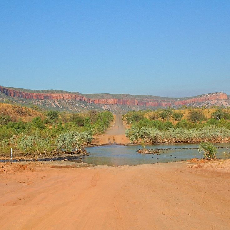
Gibb River Road traverses 410 miles (660 kilometers) of unpaved track across the Kimberley plateau in Western Australia, connecting Derby to Kununurra. This route passes through cattle stations, gorges, and areas containing rock formations that serve as natural landmarks in the Australian outback. Along the way are waterfalls including Manning Gorge and Bell Gorge, as well as sites with Aboriginal rock art. Gibb River Road is accessible during the dry season from May to October and provides entry to several national parks and waterholes in the region.
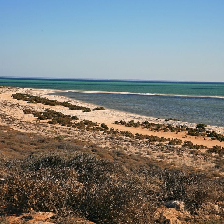
This bay is a World Heritage area on the west coast of Australia that forms part of the outback's natural landmarks. Shark Bay covers more than 8,650 square miles (22,000 square kilometers) of shallow waters, seagrass beds, and islands. The region supports approximately 10,000 dugongs, representing one of the largest populations worldwide. Bottlenose dolphins inhabit the coastal waters and can be observed at several beaches. The bay also contains stromatolites, colonies of microorganisms that represent some of Earth's oldest life forms. Hamelin Pool features one of the few locations where these structures continue to grow.
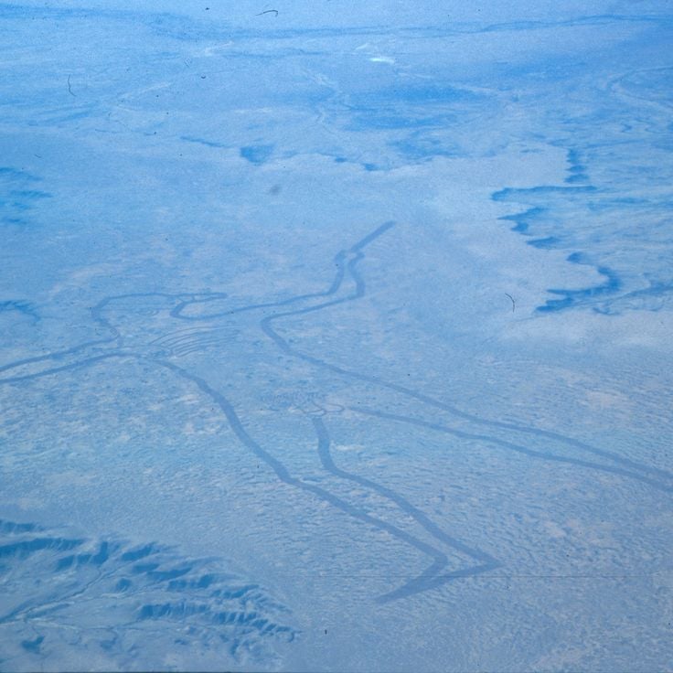
This massive geoglyph in the outback depicts the outline of an indigenous figure carved into the landscape, extending across several miles. The Marree Man was discovered in 1998 and can only be fully observed from the air. The origin and creator of this geoglyph remain unknown, generating numerous theories about its creation. The work lies in a remote region of South Australia and ranks among the largest geoglyphs in the world. The lines were created by plowing or removing the surface soil, standing out clearly from the surrounding terrain.
This gorge in the Kimberley region extends for 2 miles (3 kilometers) along the Lennard River. Windjana Gorge displays 330-foot (100-meter) high limestone walls that form part of a Devonian barrier reef. The river section is home to a population of freshwater crocodiles. The geological formation contains fossils of marine organisms. During the dry season, waterholes form along the riverbed. The walking trail passes through the gorge and along the cliff faces. The area sits within Windjana Gorge National Park and demonstrates the rock layers of the region.
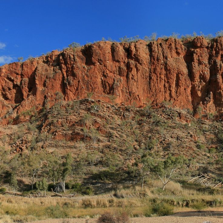
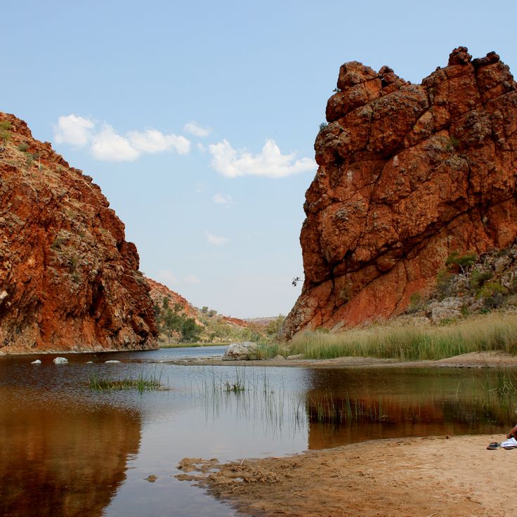
This watering hole at Glen Helen Gorge lies along the Finke River and is surrounded by red sandstone cliffs rising up to 300 feet (90 meters). The waterhole serves as an important refuge for wallabies, birds, and other regional wildlife. The gorge sits within the West MacDonnell Ranges, approximately 82 miles (132 kilometers) west of Alice Springs. Visitors can swim in the pool, walk along the banks, and observe the geological layers in the rock faces. The waterhole remains year-round even during dry seasons and forms part of the geological formations of the Australian outback. The area's traditional name comes from the local Arrernte people.
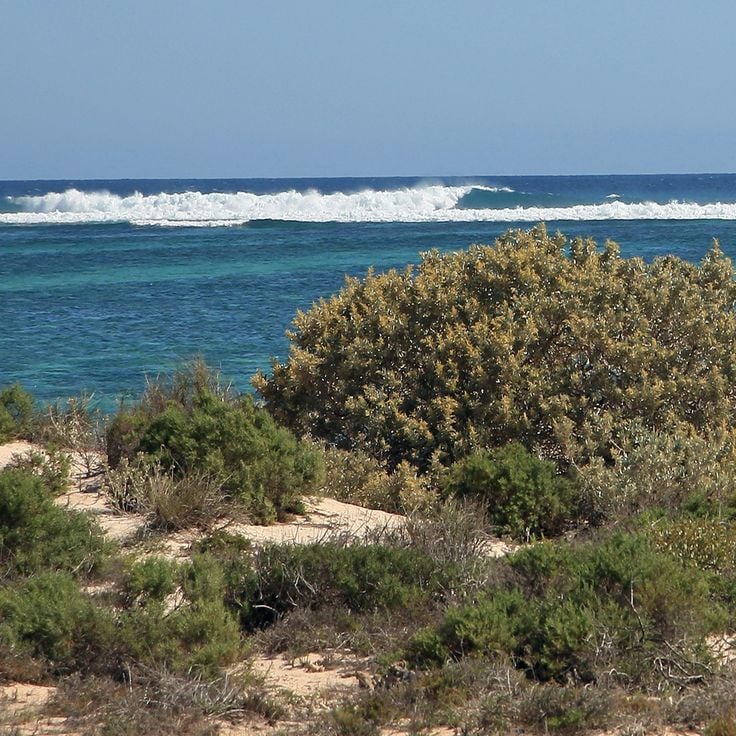
Ningaloo Reef is a coral reef system off the coast of Western Australia that extends for 160 miles (260 kilometers). This reef supports more than 500 fish species and 300 coral species in its waters. Swimmers can interact with whale sharks here between April and July when these animals migrate to the reef. The ecosystem also includes manta rays, sea turtles, and humpback whales during their migration season. This reef lies close to shore, allowing access from the beach to the coral formations.
This red sandstone monolith rises 1142 feet (348 meters) above the plain in the Northern Territory. Uluru stands as one of the most recognizable geological formations in the Australian outback and holds considerable cultural importance for Aboriginal people. The rock displays varying shades of red depending on the time of day and weather conditions. The formation developed approximately 550 million years ago through geological processes. Uluru is surrounded by walking trails that provide insights into the geology and history of the region.
These 36 rounded red sandstone formations rise from the desert landscape of the Australian outback, reaching 546 feet (approximately 167 meters) at their highest point. Kata Tjuta forms part of the territory known for sandstone rocks, canyons, and geological features alongside nearby landmarks such as Uluru and Kings Canyon. The rock formations developed through millions of years of erosion and display deep valleys and gorges running between the individual domes. The area sits within a region that also encompasses underground settlements, meteor craters, and varied ecosystems ranging from rainforests to coral reefs.
This sandstone canyon in Australia's Northern Territory reaches a depth of 890 feet (270 meters) and ranks among the significant geological formations of the Australian outback. The red rock walls of Kings Canyon contrast with green vegetation growing at the canyon floor. The formation developed over millions of years through erosion and displays various sandstone layers. The canyon is part of Watarrka National Park and offers insights into the geology of this region, which includes other sandstone structures like Uluru and Kata Tjuta among the continent's characteristic formations.
This national park in the Australian outback presents striped sandstone towers that rise up to 980 feet (300 meters). The orange and gray layers of Purnululu formed through weathering processes over millions of years. The formations are among the geological features of this region known for its sandstone structures, canyons, and expansive landscapes. The area displays the characteristic erosion patterns of the outback and provides insights into the geological history of Western Australia.
This site in the Australian outback consists of large granite rocks spread across 1800 hectares (4448 acres) in a flat landscape. The rock formations have developed through millions of years of erosion and now form one of the distinct geological features of the region. Devils Marbles (Karlu Karlu) is among the natural landmarks of the Northern Territory and demonstrates the geological processes that have shaped the Australian outback. The granite boulders lie scattered across the plain and form arrangements ranging from small stones to rocks several yards tall.
Lake Gairdner is a large salt lake in South Australia covering an area of approximately 1660 square miles (4300 square kilometers), representing one of the notable geological formations within the Australian outback. The salt surface of this lake provides a flat, hard expanse during dry periods that is regularly used for speed record attempts and motorsport events. The lake sits amid the arid landscape of the South Australian interior and occasionally forms a shallow body of water during rainy seasons before evaporating and leaving behind its characteristic salt crust. This natural landmark belongs to the group of ephemeral lakes in the region and serves as an example of the geological features that characterize the outback.
This town in the South Australian outback sits within a region containing over 250,000 mine shafts. Coober Pedy is known worldwide for its opal mining operations. Approximately 3,500 residents live in underground homes that protect them from extreme surface temperatures that can reach 122°F (50°C) in summer. The underground dwellings maintain consistent temperatures between 72 and 75°F (22 to 24°C) throughout the year. This settlement demonstrates human adaptation to Australian outback conditions through geological formations used for both mining and residential purposes.
Wilpena Pound is a mountain basin in the Flinders Ranges National Park that extends for 11 miles (17 kilometers) in length and 5 miles (8 kilometers) in width. This natural depression formed through rock layers that folded and eroded over millions of years. The steep rock walls of the basin rise up to 1,600 feet (500 meters) above the valley floor and form a natural amphitheater. Like other geological formations in the Australian outback, Wilpena Pound displays the region's geological history through visible layers of sandstone and quartzite. The basin contains walking trails, historic Adnyamathanha sites, and vegetation adapted to the arid climate.
This mountain range in central Northern Territory extends for 400 miles (644 kilometers) and forms one of the most prominent landforms in the Australian outback. The MacDonnell Ranges contain deep gorges carved by millions of years of erosion, along with numerous Aboriginal rock paintings that hold cultural significance for the local Arrernte people. The range supports permanent waterholes, eucalyptus woodlands, and habitats for rock wallabies. The geological formations display folded quartzite ridges rising above the semiarid landscape.
This meteorite crater measures 880 feet (268 meters) in diameter and formed approximately 300,000 years ago through the impact of a meteorite on the desert floor. Wolfe Creek Crater lies in a remote section of the Australian outback and represents one of the well-preserved impact structures of its kind worldwide. The crater rim rises roughly 82 feet (25 meters) above the surrounding plain and provides evidence of cosmic collisions with Earth's surface. This formation serves as a significant example of impact geology in the outback and documents the region's ancient history of meteorite activity.
This red sandstone monolith rises 3,629 feet (1,106 meters) above the territory and extends across a circumference of 30 miles (49 kilometers). Mount Augustus offers hiking trails along its base and to lookout points that provide access to geological formations and Aboriginal rock paintings. The formation developed approximately 1,650 million years ago and represents a larger monadnock than Uluru. The surroundings include gorges, seasonal waterholes, and vegetation characteristic of Australian outback wildlife.
This archaeological site in Mungo National Park contains human remains dated to 42,000 years ago and sand dunes preserving fossils and artifacts. The area documents the history of early settlement in Australia and displays geological formations from the last ice age. The lunette dunes preserve traces of ancient lakes and human activity. The park lies in the semi-arid zone of the Australian outback and forms part of the Willandra Lakes Region, recognized as a World Heritage site.
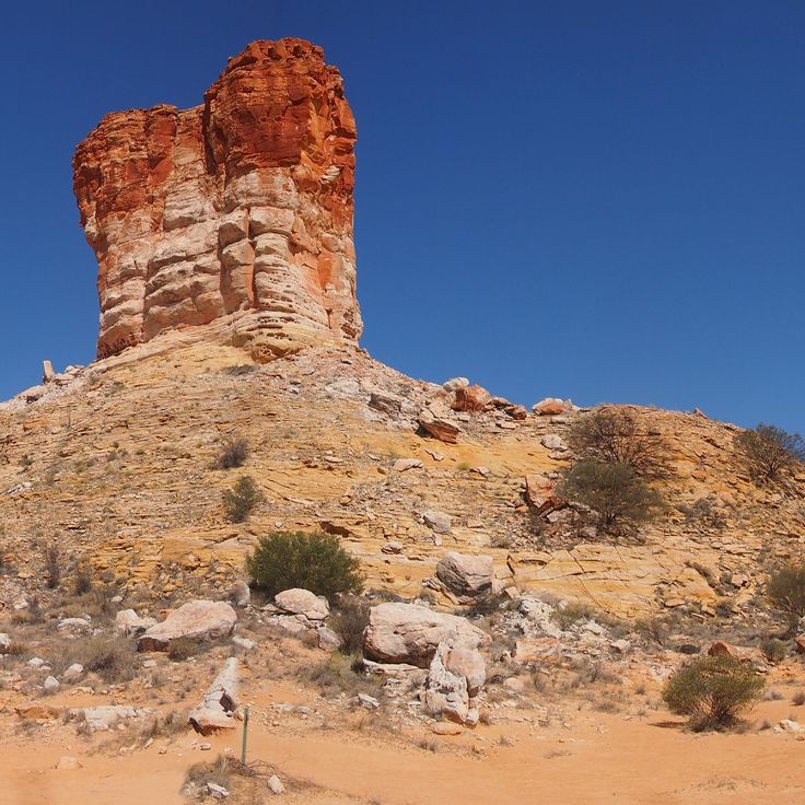
This sandstone formation in the expanse of the Australian outback rises 164 feet (50 meters) above the surrounding red sand dunes and has served as a navigation point for travelers for centuries. Chambers Pillar stands isolated in the desert landscape of the Northern Territory and displays distinct erosion patterns shaped by wind and water. The formation carries historical inscriptions from early European explorers and holds cultural significance for local Aboriginal communities. The area surrounding this geological feature consists of red sand, low scrub vegetation, and scattered rock formations typical of Australia's central desert region.
This park in the Northern Territory contains several waterfalls, including Wangi Falls, Florence Falls, and Tolmer Falls, which cascade into pools surrounded by monsoon rainforest. The natural swimming pools form within sandstone formations. The area displays magnetic termite mounds that reach up to 6 ft 7 in (2 meters) in height and align north to south due to the thermoregulatory orientation of compass termites. The park covers 580 square miles (1,500 square kilometers) and encompasses monsoon forests, eucalyptus woodland, and wetland areas. This reserve is located approximately 60 miles (100 kilometers) southwest of Darwin and documents geological formations of the Australian outback landscape.
This eucalyptus tree bears historical carvings that mark the camp site of the Burke and Wills expedition of 1861. The tree served as a supply depot during one of the most significant exploration journeys across the Australian outback. The expedition attempted to traverse the Australian continent from south to north. At the Dig Tree, the support team buried provisions and messages for the returning explorers. The markings carved into the bark remain visible today and document a significant chapter in Australian exploration history. The site is located in a remote region of Queensland and provides insight into the challenges faced during early continental exploration. This landmark represents one of the geological and historical features found throughout the territory's natural landmarks.
This desert landscape displays multicolored hills formed from sandstone, clay, and silt, colored by mineral deposits. The Painted Desert lies in the ranges south of the Flinders Ranges and forms part of the geological formations of the Australian outback. Rock strata span from the Cambrian to the Tertiary periods and include sediments deposited over millions of years. Iron oxides, manganese, and other minerals create color bands of red, orange, yellow, white, and purple across the eroded hills. This site demonstrates the geological diversity of the region alongside other natural landmarks such as Uluru and the Flinders Ranges.
These limestone caves formed during the Devonian period and create an underground system with chambers and passages. The Gooniyandi community guides visitors through the caves, which hold cultural significance in indigenous traditions and contain rock paintings as well as geological formations. Mimbi Caves is located in the Kimberley region and displays fossils from the time when the area was covered by a tropical reef. The caves contain stalactites, stalagmites, and underground pools formed through millions of years of geological processes.
This tropical rainforest is part of the Australian outback's geological diversity and houses 3000 plant species in a 180 million year old ecosystem. The Daintree Rainforest canopy reaches heights of 148 feet (45 meters) and forms a dense habitat for numerous endemic species. The forest extends across large areas and connects tropical vegetation with the natural landmarks of the region.
Karijini National Park is located in northwest Western Australia and displays some of the geological features of the outback. The park's gorges feature red rock walls reaching depths of up to 100 meters (328 feet), while several waterfalls flow into natural pools. These sandstone and iron ore formations represent an example of the canyons and water systems found in this remote region. The park is part of the larger territory that includes rock formations, waterfalls, and underground geological structures of the Australian outback.
The Cape York Peninsula covers 137,000 square miles (137,000 square kilometers) in the Australian outback and encompasses diverse ecosystems including monsoon forests, savannas, and mangrove swamps. This peninsula represents one of Australia's most sparsely populated regions with extensive wilderness areas. The territory forms the northernmost landmass of the Australian continent and borders the Torres Strait. The landscape displays geological formations that developed over millions of years, along with coastal areas adjacent to the region's coral reef systems.
This Victorian mansion from 1885 documents paranormal reports and events spanning over a century. Monte Cristo Homestead offers night tours through the original preserved rooms where visitors learn about the property's history and documented supernatural phenomena. The building stands apart from the geological formations of the Australian outback, showing a different aspect of this region's history through its collection of historical artifacts and records of unexplained occurrences.
This protected area contains ancient rainforests and alpine regions. The reserve spans over one million acres (over 400,000 hectares) and houses numerous endemic plant and animal species. The Tasmanian Wilderness preserves Precambrian rock formations, glacial landscapes, and temperate rainforests that rank among Earth's oldest. The area contains limestone caves, moorland, and river valleys. The region serves as habitat for the Tasmanian devil and other native mammals. This protected area lies beyond the continental dry zones of Australia and forms a contrast to the sandstone formations and salt plains of the outback.
These natural rock formations in red sandstone within the Northern Territory create structures resembling urban buildings. Lost City lies in a remote desert region of the Australian outback and can only be accessed by four-wheel drive vehicles through unpaved tracks. The sandstone formations display erosion patterns that are part of the geological diversity of this region. The area sits far from paved roads and requires appropriate vehicles and preparation for visiting.
Gibb River Road traverses 410 miles (660 kilometers) of unpaved track across the Kimberley plateau in Western Australia, connecting Derby to Kununurra. This route passes through cattle stations, gorges, and areas containing rock formations that serve as natural landmarks in the Australian outback. Along the way are waterfalls including Manning Gorge and Bell Gorge, as well as sites with Aboriginal rock art. Gibb River Road is accessible during the dry season from May to October and provides entry to several national parks and waterholes in the region.
This bay is a World Heritage area on the west coast of Australia that forms part of the outback's natural landmarks. Shark Bay covers more than 8,650 square miles (22,000 square kilometers) of shallow waters, seagrass beds, and islands. The region supports approximately 10,000 dugongs, representing one of the largest populations worldwide. Bottlenose dolphins inhabit the coastal waters and can be observed at several beaches. The bay also contains stromatolites, colonies of microorganisms that represent some of Earth's oldest life forms. Hamelin Pool features one of the few locations where these structures continue to grow.
This massive geoglyph in the outback depicts the outline of an indigenous figure carved into the landscape, extending across several miles. The Marree Man was discovered in 1998 and can only be fully observed from the air. The origin and creator of this geoglyph remain unknown, generating numerous theories about its creation. The work lies in a remote region of South Australia and ranks among the largest geoglyphs in the world. The lines were created by plowing or removing the surface soil, standing out clearly from the surrounding terrain.
This gorge in the Kimberley region extends for 2 miles (3 kilometers) along the Lennard River. Windjana Gorge displays 330-foot (100-meter) high limestone walls that form part of a Devonian barrier reef. The river section is home to a population of freshwater crocodiles. The geological formation contains fossils of marine organisms. During the dry season, waterholes form along the riverbed. The walking trail passes through the gorge and along the cliff faces. The area sits within Windjana Gorge National Park and demonstrates the rock layers of the region.
This watering hole at Glen Helen Gorge lies along the Finke River and is surrounded by red sandstone cliffs rising up to 300 feet (90 meters). The waterhole serves as an important refuge for wallabies, birds, and other regional wildlife. The gorge sits within the West MacDonnell Ranges, approximately 82 miles (132 kilometers) west of Alice Springs. Visitors can swim in the pool, walk along the banks, and observe the geological layers in the rock faces. The waterhole remains year-round even during dry seasons and forms part of the geological formations of the Australian outback. The area's traditional name comes from the local Arrernte people.
Ningaloo Reef is a coral reef system off the coast of Western Australia that extends for 160 miles (260 kilometers). This reef supports more than 500 fish species and 300 coral species in its waters. Swimmers can interact with whale sharks here between April and July when these animals migrate to the reef. The ecosystem also includes manta rays, sea turtles, and humpback whales during their migration season. This reef lies close to shore, allowing access from the beach to the coral formations.
This red sandstone monolith rises 1142 feet (348 meters) above the plain in the Northern Territory. Uluru stands as one of the most recognizable geological formations in the Australian outback and holds considerable cultural importance for Aboriginal people. The rock displays varying shades of red depending on the time of day and weather conditions. The formation developed approximately 550 million years ago through geological processes. Uluru is surrounded by walking trails that provide insights into the geology and history of the region.
These 36 rounded red sandstone formations rise from the desert landscape of the Australian outback, reaching 546 feet (approximately 167 meters) at their highest point. Kata Tjuta forms part of the territory known for sandstone rocks, canyons, and geological features alongside nearby landmarks such as Uluru and Kings Canyon. The rock formations developed through millions of years of erosion and display deep valleys and gorges running between the individual domes. The area sits within a region that also encompasses underground settlements, meteor craters, and varied ecosystems ranging from rainforests to coral reefs.
This sandstone canyon in Australia's Northern Territory reaches a depth of 890 feet (270 meters) and ranks among the significant geological formations of the Australian outback. The red rock walls of Kings Canyon contrast with green vegetation growing at the canyon floor. The formation developed over millions of years through erosion and displays various sandstone layers. The canyon is part of Watarrka National Park and offers insights into the geology of this region, which includes other sandstone structures like Uluru and Kata Tjuta among the continent's characteristic formations.
This national park in the Australian outback presents striped sandstone towers that rise up to 980 feet (300 meters). The orange and gray layers of Purnululu formed through weathering processes over millions of years. The formations are among the geological features of this region known for its sandstone structures, canyons, and expansive landscapes. The area displays the characteristic erosion patterns of the outback and provides insights into the geological history of Western Australia.
This site in the Australian outback consists of large granite rocks spread across 1800 hectares (4448 acres) in a flat landscape. The rock formations have developed through millions of years of erosion and now form one of the distinct geological features of the region. Devils Marbles (Karlu Karlu) is among the natural landmarks of the Northern Territory and demonstrates the geological processes that have shaped the Australian outback. The granite boulders lie scattered across the plain and form arrangements ranging from small stones to rocks several yards tall.
Lake Gairdner is a large salt lake in South Australia covering an area of approximately 1660 square miles (4300 square kilometers), representing one of the notable geological formations within the Australian outback. The salt surface of this lake provides a flat, hard expanse during dry periods that is regularly used for speed record attempts and motorsport events. The lake sits amid the arid landscape of the South Australian interior and occasionally forms a shallow body of water during rainy seasons before evaporating and leaving behind its characteristic salt crust. This natural landmark belongs to the group of ephemeral lakes in the region and serves as an example of the geological features that characterize the outback.
This town in the South Australian outback sits within a region containing over 250,000 mine shafts. Coober Pedy is known worldwide for its opal mining operations. Approximately 3,500 residents live in underground homes that protect them from extreme surface temperatures that can reach 122°F (50°C) in summer. The underground dwellings maintain consistent temperatures between 72 and 75°F (22 to 24°C) throughout the year. This settlement demonstrates human adaptation to Australian outback conditions through geological formations used for both mining and residential purposes.
Wilpena Pound is a mountain basin in the Flinders Ranges National Park that extends for 11 miles (17 kilometers) in length and 5 miles (8 kilometers) in width. This natural depression formed through rock layers that folded and eroded over millions of years. The steep rock walls of the basin rise up to 1,600 feet (500 meters) above the valley floor and form a natural amphitheater. Like other geological formations in the Australian outback, Wilpena Pound displays the region's geological history through visible layers of sandstone and quartzite. The basin contains walking trails, historic Adnyamathanha sites, and vegetation adapted to the arid climate.
This mountain range in central Northern Territory extends for 400 miles (644 kilometers) and forms one of the most prominent landforms in the Australian outback. The MacDonnell Ranges contain deep gorges carved by millions of years of erosion, along with numerous Aboriginal rock paintings that hold cultural significance for the local Arrernte people. The range supports permanent waterholes, eucalyptus woodlands, and habitats for rock wallabies. The geological formations display folded quartzite ridges rising above the semiarid landscape.
This meteorite crater measures 880 feet (268 meters) in diameter and formed approximately 300,000 years ago through the impact of a meteorite on the desert floor. Wolfe Creek Crater lies in a remote section of the Australian outback and represents one of the well-preserved impact structures of its kind worldwide. The crater rim rises roughly 82 feet (25 meters) above the surrounding plain and provides evidence of cosmic collisions with Earth's surface. This formation serves as a significant example of impact geology in the outback and documents the region's ancient history of meteorite activity.
This red sandstone monolith rises 3,629 feet (1,106 meters) above the territory and extends across a circumference of 30 miles (49 kilometers). Mount Augustus offers hiking trails along its base and to lookout points that provide access to geological formations and Aboriginal rock paintings. The formation developed approximately 1,650 million years ago and represents a larger monadnock than Uluru. The surroundings include gorges, seasonal waterholes, and vegetation characteristic of Australian outback wildlife.
This archaeological site in Mungo National Park contains human remains dated to 42,000 years ago and sand dunes preserving fossils and artifacts. The area documents the history of early settlement in Australia and displays geological formations from the last ice age. The lunette dunes preserve traces of ancient lakes and human activity. The park lies in the semi-arid zone of the Australian outback and forms part of the Willandra Lakes Region, recognized as a World Heritage site.
This sandstone formation in the expanse of the Australian outback rises 164 feet (50 meters) above the surrounding red sand dunes and has served as a navigation point for travelers for centuries. Chambers Pillar stands isolated in the desert landscape of the Northern Territory and displays distinct erosion patterns shaped by wind and water. The formation carries historical inscriptions from early European explorers and holds cultural significance for local Aboriginal communities. The area surrounding this geological feature consists of red sand, low scrub vegetation, and scattered rock formations typical of Australia's central desert region.
This park in the Northern Territory contains several waterfalls, including Wangi Falls, Florence Falls, and Tolmer Falls, which cascade into pools surrounded by monsoon rainforest. The natural swimming pools form within sandstone formations. The area displays magnetic termite mounds that reach up to 6 ft 7 in (2 meters) in height and align north to south due to the thermoregulatory orientation of compass termites. The park covers 580 square miles (1,500 square kilometers) and encompasses monsoon forests, eucalyptus woodland, and wetland areas. This reserve is located approximately 60 miles (100 kilometers) southwest of Darwin and documents geological formations of the Australian outback landscape.
This eucalyptus tree bears historical carvings that mark the camp site of the Burke and Wills expedition of 1861. The tree served as a supply depot during one of the most significant exploration journeys across the Australian outback. The expedition attempted to traverse the Australian continent from south to north. At the Dig Tree, the support team buried provisions and messages for the returning explorers. The markings carved into the bark remain visible today and document a significant chapter in Australian exploration history. The site is located in a remote region of Queensland and provides insight into the challenges faced during early continental exploration. This landmark represents one of the geological and historical features found throughout the territory's natural landmarks.
This desert landscape displays multicolored hills formed from sandstone, clay, and silt, colored by mineral deposits. The Painted Desert lies in the ranges south of the Flinders Ranges and forms part of the geological formations of the Australian outback. Rock strata span from the Cambrian to the Tertiary periods and include sediments deposited over millions of years. Iron oxides, manganese, and other minerals create color bands of red, orange, yellow, white, and purple across the eroded hills. This site demonstrates the geological diversity of the region alongside other natural landmarks such as Uluru and the Flinders Ranges.
These limestone caves formed during the Devonian period and create an underground system with chambers and passages. The Gooniyandi community guides visitors through the caves, which hold cultural significance in indigenous traditions and contain rock paintings as well as geological formations. Mimbi Caves is located in the Kimberley region and displays fossils from the time when the area was covered by a tropical reef. The caves contain stalactites, stalagmites, and underground pools formed through millions of years of geological processes.
This tropical rainforest is part of the Australian outback's geological diversity and houses 3000 plant species in a 180 million year old ecosystem. The Daintree Rainforest canopy reaches heights of 148 feet (45 meters) and forms a dense habitat for numerous endemic species. The forest extends across large areas and connects tropical vegetation with the natural landmarks of the region.
Karijini National Park is located in northwest Western Australia and displays some of the geological features of the outback. The park's gorges feature red rock walls reaching depths of up to 100 meters (328 feet), while several waterfalls flow into natural pools. These sandstone and iron ore formations represent an example of the canyons and water systems found in this remote region. The park is part of the larger territory that includes rock formations, waterfalls, and underground geological structures of the Australian outback.
The Cape York Peninsula covers 137,000 square miles (137,000 square kilometers) in the Australian outback and encompasses diverse ecosystems including monsoon forests, savannas, and mangrove swamps. This peninsula represents one of Australia's most sparsely populated regions with extensive wilderness areas. The territory forms the northernmost landmass of the Australian continent and borders the Torres Strait. The landscape displays geological formations that developed over millions of years, along with coastal areas adjacent to the region's coral reef systems.
This Victorian mansion from 1885 documents paranormal reports and events spanning over a century. Monte Cristo Homestead offers night tours through the original preserved rooms where visitors learn about the property's history and documented supernatural phenomena. The building stands apart from the geological formations of the Australian outback, showing a different aspect of this region's history through its collection of historical artifacts and records of unexplained occurrences.
This protected area contains ancient rainforests and alpine regions. The reserve spans over one million acres (over 400,000 hectares) and houses numerous endemic plant and animal species. The Tasmanian Wilderness preserves Precambrian rock formations, glacial landscapes, and temperate rainforests that rank among Earth's oldest. The area contains limestone caves, moorland, and river valleys. The region serves as habitat for the Tasmanian devil and other native mammals. This protected area lies beyond the continental dry zones of Australia and forms a contrast to the sandstone formations and salt plains of the outback.
These natural rock formations in red sandstone within the Northern Territory create structures resembling urban buildings. Lost City lies in a remote desert region of the Australian outback and can only be accessed by four-wheel drive vehicles through unpaved tracks. The sandstone formations display erosion patterns that are part of the geological diversity of this region. The area sits far from paved roads and requires appropriate vehicles and preparation for visiting.
Gibb River Road traverses 410 miles (660 kilometers) of unpaved track across the Kimberley plateau in Western Australia, connecting Derby to Kununurra. This route passes through cattle stations, gorges, and areas containing rock formations that serve as natural landmarks in the Australian outback. Along the way are waterfalls including Manning Gorge and Bell Gorge, as well as sites with Aboriginal rock art. Gibb River Road is accessible during the dry season from May to October and provides entry to several national parks and waterholes in the region.
This bay is a World Heritage area on the west coast of Australia that forms part of the outback's natural landmarks. Shark Bay covers more than 8,650 square miles (22,000 square kilometers) of shallow waters, seagrass beds, and islands. The region supports approximately 10,000 dugongs, representing one of the largest populations worldwide. Bottlenose dolphins inhabit the coastal waters and can be observed at several beaches. The bay also contains stromatolites, colonies of microorganisms that represent some of Earth's oldest life forms. Hamelin Pool features one of the few locations where these structures continue to grow.
This massive geoglyph in the outback depicts the outline of an indigenous figure carved into the landscape, extending across several miles. The Marree Man was discovered in 1998 and can only be fully observed from the air. The origin and creator of this geoglyph remain unknown, generating numerous theories about its creation. The work lies in a remote region of South Australia and ranks among the largest geoglyphs in the world. The lines were created by plowing or removing the surface soil, standing out clearly from the surrounding terrain.
This gorge in the Kimberley region extends for 2 miles (3 kilometers) along the Lennard River. Windjana Gorge displays 330-foot (100-meter) high limestone walls that form part of a Devonian barrier reef. The river section is home to a population of freshwater crocodiles. The geological formation contains fossils of marine organisms. During the dry season, waterholes form along the riverbed. The walking trail passes through the gorge and along the cliff faces. The area sits within Windjana Gorge National Park and demonstrates the rock layers of the region.
This watering hole at Glen Helen Gorge lies along the Finke River and is surrounded by red sandstone cliffs rising up to 300 feet (90 meters). The waterhole serves as an important refuge for wallabies, birds, and other regional wildlife. The gorge sits within the West MacDonnell Ranges, approximately 82 miles (132 kilometers) west of Alice Springs. Visitors can swim in the pool, walk along the banks, and observe the geological layers in the rock faces. The waterhole remains year-round even during dry seasons and forms part of the geological formations of the Australian outback. The area's traditional name comes from the local Arrernte people.
Ningaloo Reef is a coral reef system off the coast of Western Australia that extends for 160 miles (260 kilometers). This reef supports more than 500 fish species and 300 coral species in its waters. Swimmers can interact with whale sharks here between April and July when these animals migrate to the reef. The ecosystem also includes manta rays, sea turtles, and humpback whales during their migration season. This reef lies close to shore, allowing access from the beach to the coral formations.