See the monuments around you in AROpen chests in the app
Around Us is built for your phone — point your camera at the streets and discover the monuments and places around you in augmented reality.Around Us is built for your phone — chests unlock when you walk, explore and capture nearby places.
Geological formations and natural wonders on Earth
The Earth offers a wide range of geological shapes shaped over millions of years by weather and the movements of the land. In Northern Ireland, thousands of basalt columns stand along the coast, leftover from an ancient eruption. In Arizona, the Colorado River carved out a canyon more than 400 miles long. In Bolivia, a salt flat forms a giant mirror during the rainy season.
You can also find white terraces formed by hot springs in Turkey, eroded sandstone arches in the American desert, or the largest coral reef in the world off Australia. Some formations show that volcanic activity still occurs, like in Yellowstone Park. Others are the result of tectonic plate collisions, such as the Himalayas where Mount Everest rises. These places tell the story of Earth's geology and are still changing under the influence of wind, water, and moving continents.
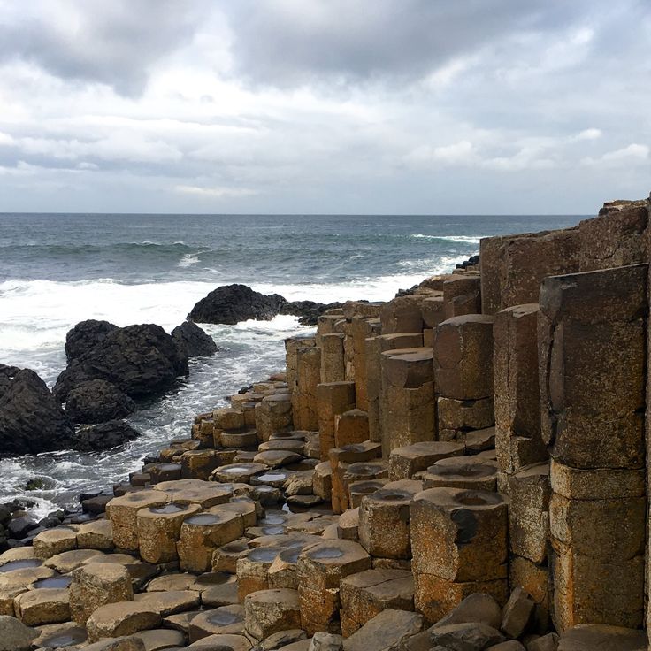
The Giant's Causeway tells the story of Earth's geology by showing how volcanic activity shaped the landscape over millions of years. These basalt columns in County Antrim formed around 60 million years ago when lava reached the surface and cooled into hexagonal shapes. About 40,000 columns rise along the coast, some reaching 12 meters (40 feet) high, and fit together like paving stones. You can walk on the flat tops at low tide. The basalt ranges in color from gray to reddish depending on light and moisture. Seabirds nest in the rock crevices, and waves crash against the lower formations.
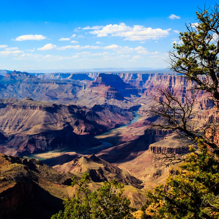
The Grand Canyon is a large river valley carved by the Colorado River over millions of years into the high plateau of Arizona. The gorge runs roughly 450 kilometers (280 miles) through the desert landscape and displays layers of rock from different geological eras on its walls. Anyone standing at the rim looks down more than 1,000 meters (3,000 feet) to the river. Light shifts during the day and tints the cliffs from pale red through orange to violet. Trails lead from the upper plateau down to the water, past cacti and dry pines. The river itself has not finished its work and continues to dig into the rock, while rain and wind alter the shapes of the cliff faces. The Grand Canyon demonstrates how water, time, and movement of the land shape the Earth's surface in ways that take millions of years to unfold.
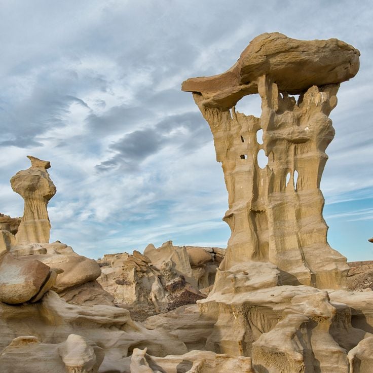
Valley of Dreams sits in northwestern New Mexico and displays gray and white hills made of petrified wood and mineral-rich sediments. This landscape formed from deposits left by rivers and lakes about 70 million years ago, when the region was a humid lowland. Wind and water have exposed the soft rock and shaped it into waves and cones. The petrified wood comes from trees that were buried by volcanic ash and replaced by silica. You walk on dry ground between formations that change color with the light.
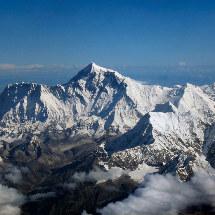
Mount Everest represents the power of tectonic plate collisions in Earth's geological story. The mountain rises 8,849 meters (29,032 feet) above sea level as the tallest peak on the planet. Mount Everest formed millions of years ago when the Indian and Eurasian plates collided, a process still happening today as the landmasses continue to push against each other. From the Tibetan side, the summit looks like a sharp pyramid of rock and ice, while glaciers flow down the southern face in Nepal between steep cliffs. The air grows thin at this altitude, making breathing difficult without extra oxygen. The surrounding landscape is harsh and unforgiving, marked by extreme cold, strong winds, and deep crevasses.
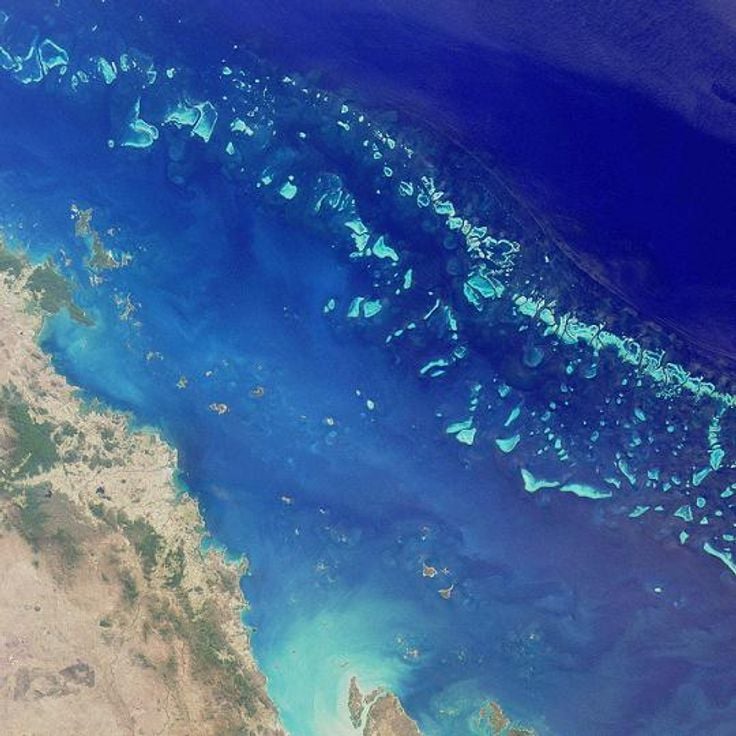
The Great Barrier Reef extends along the coast of Queensland and stands as one of the largest structures created by living organisms. This coral reef contains thousands of individual coral blocks and islands in warm, shallow water. The coral gardens display many colors: pink, orange, purple and yellow. Fish, turtles and rays swim among the corals. Visitors travel by boat to snorkel or dive. The water is typically clear and turquoise. The corals grow slowly and remain sensitive to temperature changes.
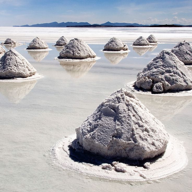
The Salar de Uyuni is a salt flat on the Bolivian altiplano and represents one of Earth's remarkable geological formations shaped over millions of years. After rainfall, a thin layer of water covers the white surface and mirrors the sky above. During the dry season, the salt crust breaks into hexagonal patterns that spread across the level ground. A lake once covered this area, then evaporated and left behind thick deposits of salt and minerals. Cacti grow on islands made of volcanic rock, flamingos feed at shallow lagoons, and villages harvest salt from the ground. The air is dry, the sun strong under a clear sky, and the open space makes distances hard to judge.
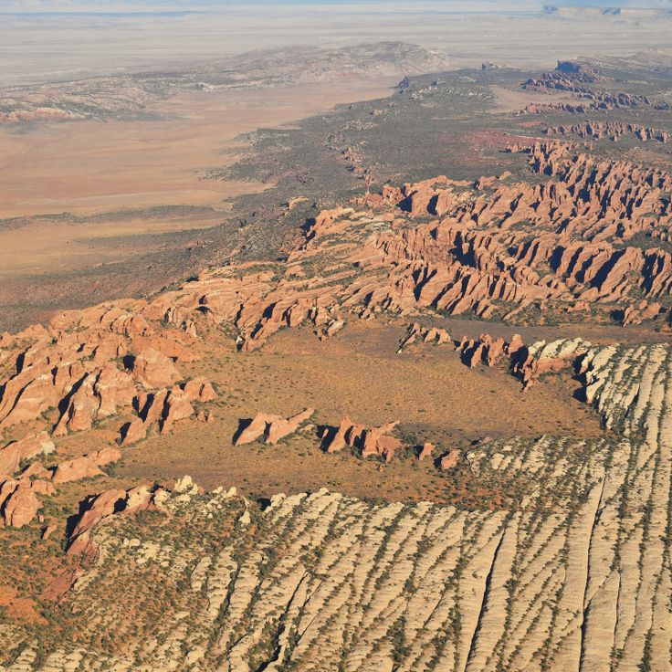
Devil's Garden sits within Grand Staircase-Escalante National Monument and holds a landscape shaped by wind and water over millions of years. Red and orange sandstone rises from the ground, with narrow passages and natural arches carved by erosion. The arches appear as openings in the rock, forming passages you can walk through. The sandstone is soft and porous, allowing water to seep in and wear away material. Over time, cavities and cracks form. The surroundings are dry, vegetation is sparse, with only scattered desert plants growing among the rocks. Visitors move between rock formations that differ in color and shape. Some arches are wide and tall, others narrow and low. The terrain is uneven, the path crosses rock surfaces and sandy stretches.
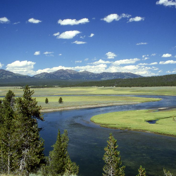
The Yellowstone Caldera showcases one of North America's most active volcanic systems and serves as a key example of the geological forces that shape our planet. Beneath the surface lies a massive magma chamber, whose activity reveals itself through hot springs, geysers, and mudpots that constantly release steam and water. The ground rises and falls year after year, a sign that this system remains alive. The landscape shifts between forested hills and open valleys where sulfurous vapors rise into the air. Visitors walk along wooden boardwalks through fields where rock is stained orange, yellow, and green by mineral deposits. The heat beneath the ground influences all life at the surface. Three major eruptions over the past two million years have shaped this caldera. Scientists continuously monitor the volcanic activity to track changes.
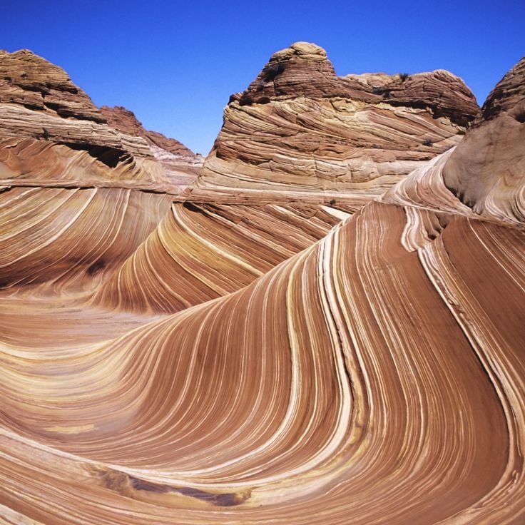
The Wave is a sandstone formation made of Navajo rock laid down around 190 million years ago. Fine sand from ancient dunes hardened over time, leaving layers that now curve in ribbons of ochre, orange, and red. Wind and rain continue to shape the surface, bringing out the bands. Reaching The Wave requires a hike of about 6 kilometers (3.6 miles) across open ground with no marked trail, so visitors rely on GPS or a map. The sun beats down most of the day, and shade is rare. Daily visitor numbers are limited to protect the rock. The route crosses narrow slots and slickrock before arriving at the formation.
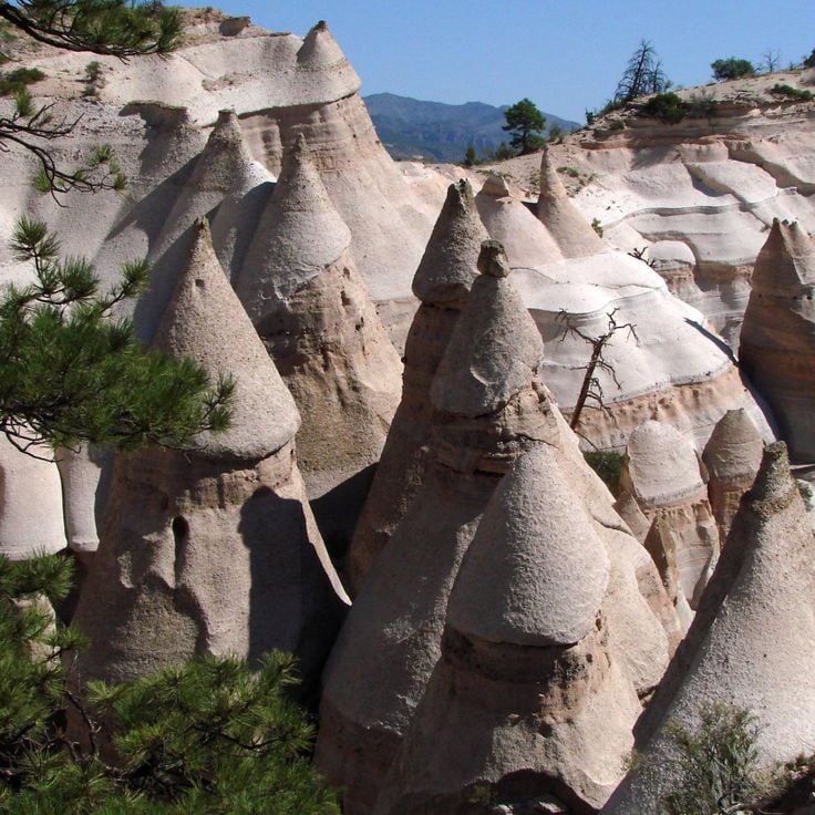
Kasha-Katuwe Tent Rocks National Monument displays volcanic ash layers shaped over six to seven million years into slender cone formations with pointed caps. Wind and water erosion wore away softer material faster than the harder protective rock at the tips, creating this distinctive pattern. The formations sit within a landscape of canyons and mesa plateaus in the New Mexico highlands. A trail passes through narrow slots between walls of banded tuff rock and gives views across the surrounding high desert. The layers show different shades from tan to gray that shift with changing light.
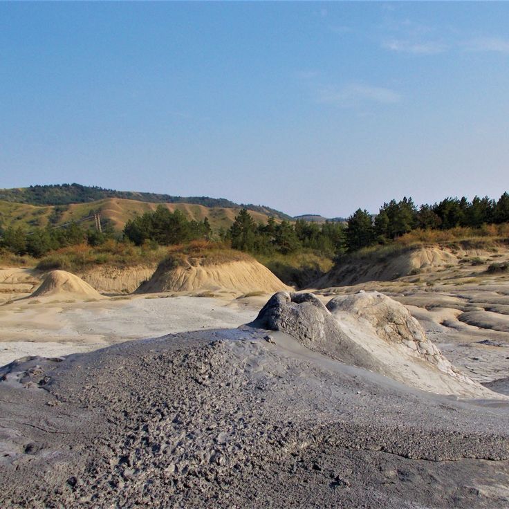
The Muddy Volcanoes of Buzău are part of Earth's geological formations, demonstrating how natural forces shape landscapes over millions of years. These mud volcanoes form when natural gas rises through layers of sediment and pushes mud to the surface. Small cones and craters emerge with gray bubbles coming from them. The terrain appears barren and resembles a lunar landscape. When it rains, the ground becomes a slippery mass. Activity is continuous but slow-moving. The mud is cool and contains minerals. The landscape is flat and surrounded by sparse vegetation.
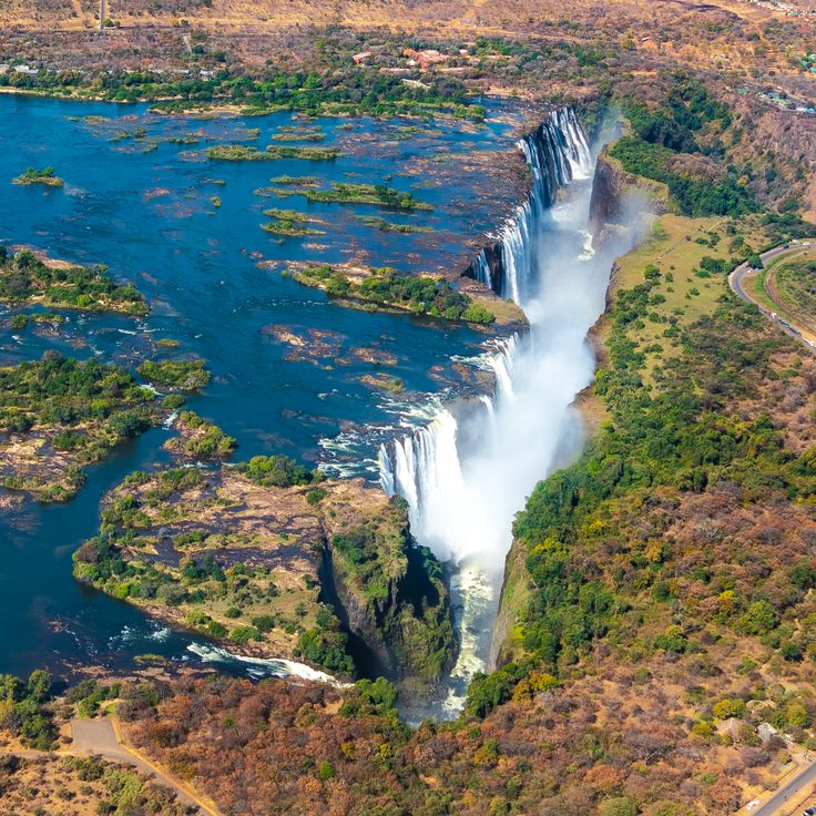
Victoria Falls is a waterfall system that drops across a width of 1700 meters into a narrow gorge carved by the river over millions of years into the rock below. Water plunges 108 meters as the Zambezi River carries it over the edge in a dramatic flow. During the rainy season, the volume of water increases sharply, and the rising mist can be seen from several kilometers away. In the dry season, the river splits into several streams, and parts of the rock face become visible. The gorge continues to form through ongoing erosion as the falling water deepens the channel. Vegetation along the falls benefits from the constant moisture brought by the spray. On both sides of the gorge, paths run along the rock edge, offering views of the water's power and movement.
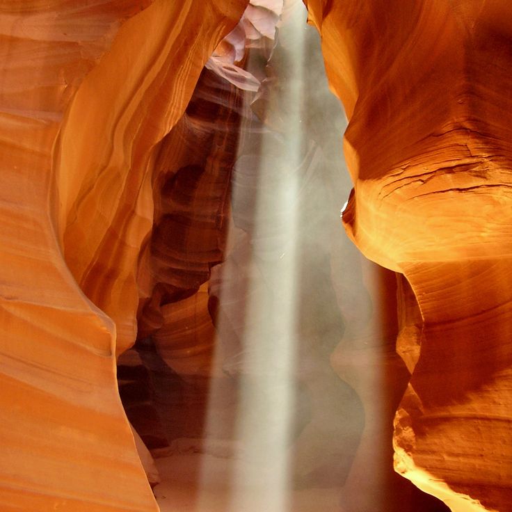
Antelope Canyon shows how water shaped sandstone over thousands of years. Narrow passages formed through erosion, while wind and rain polished the reddish walls. Smooth surfaces with wavy lines and curved shapes mark the landscape. Light enters through openings from above and casts changing colors on the rock. In some places, the passages are so tight that you need to squeeze between the walls. This canyon belongs to the geological formations that arise from the force of water in dry regions.
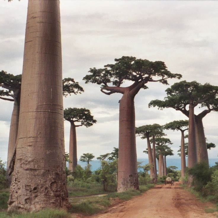
The Avenue of the Baobabs demonstrates how Earth's landscapes evolve over long periods. This tree-lined road lies west of Morondava and connects several villages across the plain. About a dozen baobab trees stand along an unpaved road surrounded by rice paddies and dry pastures. The trees belong to a species found only in Madagascar. Their trunks store water during the rainy season and can live for several hundred years. The road is used mostly at dusk by ox carts and people on foot. Some trees reach 100 feet (30 meters) in height.
The Jeita Grotto demonstrates the geological forces that have shaped the Earth over millions of years. This site consists of two interconnected limestone cave systems in the mountains north of Beirut. The lower cave contains an underground river flowing through large chambers accessible by boat. The upper cave can be explored on foot and displays stalactites and stalagmites in reddish and white tones. Water has deposited calcite over thousands of years, creating columns, draperies and pools. The Jeita Grotto also serves as a drinking water source for the region.
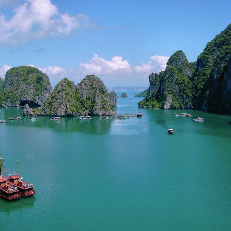
Along Bay displays how limestone transforms over millions of years through the action of water. More than 1600 islands and rock formations rise from the water, created by karst processes that shaped this landscape. The steep slopes of the islands support dense vegetation, while the water in the bay remains generally calm. Fishermen navigate small boats through the rocks, and caves become accessible when tides permit. This place demonstrates how geological forces continue to reshape the Earth's surface.
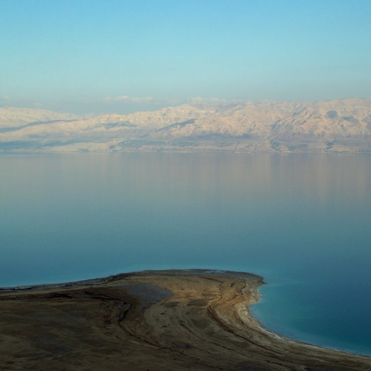
The Dead Sea represents one of Earth's most extreme geological phenomena and belongs in this collection of natural wonders. This body of water sits at the lowest point on Earth's surface, more than 1,300 feet (400 meters) below sea level. The water holds a salt concentration of around 34 percent, ten times higher than the ocean. Anyone who enters floats effortlessly at the surface. The shoreline is often lined with white salt crusts that glint in the sunlight. The surrounding landscape is barren, with dry hills and sparse vegetation. Almost no life survives in this water. The air down here is warm and thick, especially in summer. People come to coat themselves in the mineral-rich mud. The water evaporates constantly, so the surface has been shrinking for decades. The silence is notable, with no waves breaking the smooth expanse.
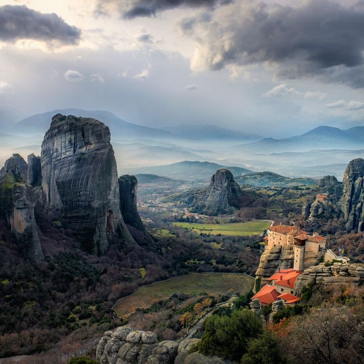
Meteora displays striking sandstone pillars that rise up to 400 meters above the Thessalian plain, part of a geological collection documenting Earth's diverse landforms shaped over millions of years. Six monasteries perched on these pillars date from the 14th and 15th centuries, forming one of Europe's most unusual religious complexes. Monks originally reached the summits using ladders and rope hoists. Today, staircases carved into the rock provide access. From the top, you look out over pine forests and fields below. The monasteries remain inhabited and house icons and frescoes from the late Middle Ages.
Wulingyuan Scenic Area displays more than 3,000 sandstone pillars rising up to 200 meters (656 feet) that formed through erosion over millions of years. The landscape features scattered rock formations in valleys and plateaus that resemble a natural maze. About 40 caves and two large natural bridges carved from the same sandstone cut through the terrain. Vegetation grows on the rocks and within crevices. Rivers and streams flow through the area, continuously shaping the stone. Mist and clouds frequently envelope the pillar tops and constantly change how the landscape appears. The caves offer glimpses into the inner layers of sandstone and reveal the geological story written in stone.
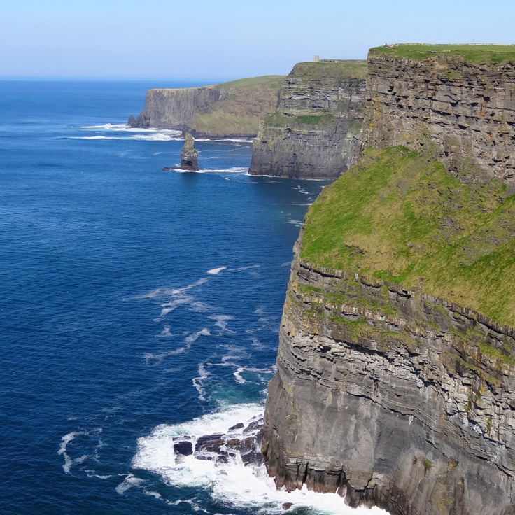
The Cliffs of Moher in County Clare represent the geological formations that shape Earth, built over millions of years through natural forces. These cliffs rise about 214 meters (700 feet) above the Atlantic and extend eight kilometers along Ireland's west coast. Wind has shaped the layers of shale and sandstone for thousands of years. Visitors walk on narrow paths near the edge while birds nest in large colonies on the steep rock faces. The 19th-century tower stands at one of the highest points and offers views across Galway Bay and the Aran Islands. On stormy days, spray reaches far up the cliffs as the ocean crashes directly against the rock. The landscape appears both bare and green at once, with grass growing right to the edge of the precipice.
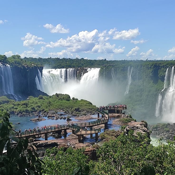
These waterfalls at the border between Argentina and Brazil stretch across nearly 2 miles through subtropical rainforest. Hundreds of water streams drop between rock walls and forested islands. The Devil's Throat forms the heart of the site: a horseshoe-shaped chasm where water crashes down with a roar and creates a permanent mist cloud. Narrow walkways lead to the edge of the cascades, where moisture clings to the skin and rainbows appear in the spray. The Argentine side brings visitors close to the waterfalls, while the Brazilian side offers a wide view of the entire panorama. This geological formation demonstrates the power of water erosion over time.
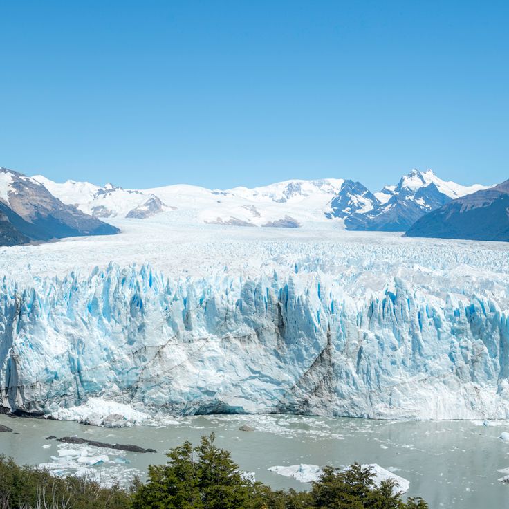
This glacier represents one of Earth's geological wonders, showing how ice shapes landscapes over millions of years. The Perito Moreno Glacier stretches across the Andes and pushes into a lake, where its wall of bluish ice rises in places to around 240 feet (70 meters). The ice creaks, cracks and breaks off regularly, with large blocks crashing into the water with a deep rumble. From viewing platforms you can watch the mass slowly advance and shape itself through its own weight. Unlike many other glaciers in the region, this one does not retreat but holds its volume. The movement is visible, the ice seems alive. Visitor paths lead close to the front, some take guided walks on the surface. The cold, the light and the sound of falling ice blocks shape the place.
The Danxia formation in Gansu Province shows the geological processes that shaped the Earth over millions of years. Horizontal layers of sandstone stack upon one another, displaying bands ranging from red to yellow to orange. This coloring comes from different minerals, mainly iron oxide and other metal compounds that settled over time. Rain and wind have eroded the softer rock layers unevenly, creating wavy surfaces and grooves. The color contrasts become more visible as light changes throughout the day. This formation tells the story of Earth's geology and demonstrates how water and wind continue to reshape the landscape.
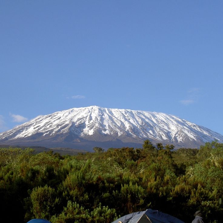
Mount Kilimanjaro is an inactive volcano in East Africa composed of three cones: Kibo, Mawenzi, and Shira. Its highest point reaches 19341 feet (5895 meters) above sea level. The upper reaches carry glaciers that have shrunk considerably over recent decades. The mountain's slopes display distinct vegetation zones, from tropical rainforest at the base to alpine desert at higher elevations. The volcano formed through tectonic activity in the East African Rift and has been dormant for around 150000 years. Its shape dominates the landscape far across the Tanzanian plateau, telling the story of Earth's geological forces.
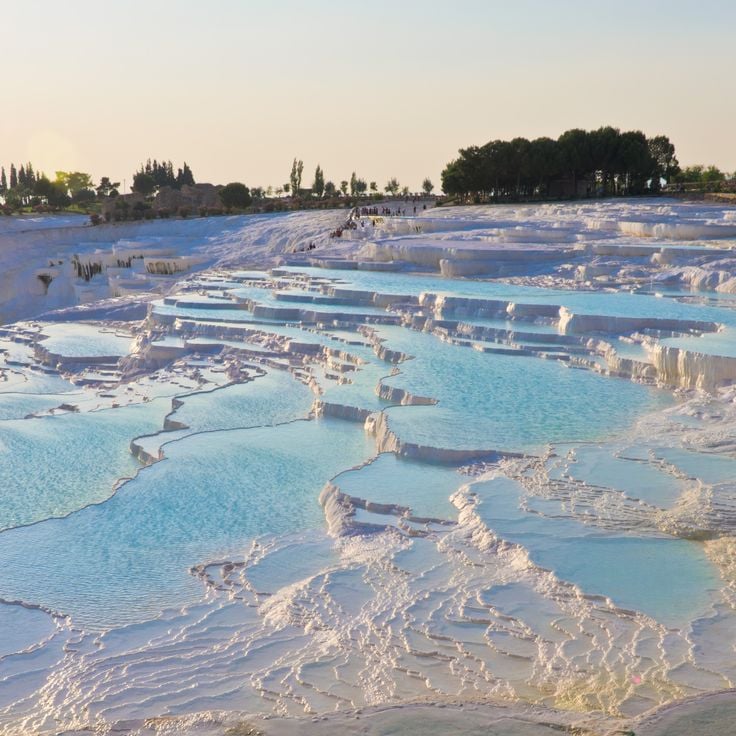
Pamukkale is one of the geological formations that shape our planet. In southwestern Turkey, hot springs deliver mineral-rich water over limestone terraces, creating pools at different levels. As the water cools, it deposits calcium carbonate and forms white structures that look like cascading cotton or cauliflower. The water remains warm even in the lower pools. The white color comes from mineral deposits. Visitors walk barefoot across the upper terraces where shallow pools form. The contrast between the white limestone and the blue water creates a striking visual effect. The slopes below the plateau show how minerals have accumulated over thousands of years. The site has been used as a bathing place since ancient times.
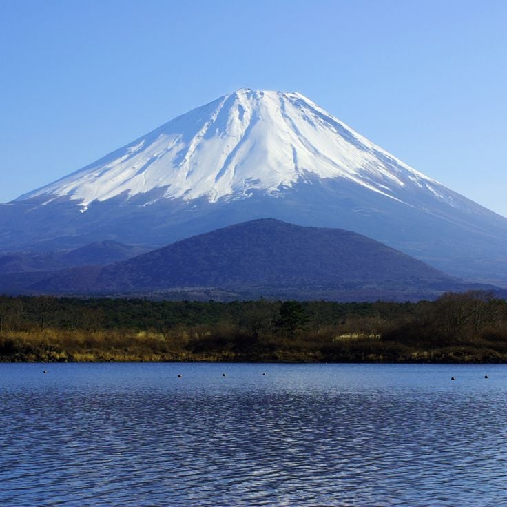
Mount Fuji is a dormant volcano that demonstrates how volcanic activity shapes the Earth's geology. With a height of 3776 meters and its symmetrical cone shape, this mountain stands alone on the Kanto plain. The snow-capped peak is visible from Tokyo on clear days. The volcano's last eruption occurred in 1707. Lower slopes are covered with forests, while higher elevations have sparse vegetation. In winter, snow blankets the upper reaches and contrasts sharply with the dark volcanic rock. Hikers follow established routes to the summit, passing through different ecological zones that show how volcanic mountains create varied habitats.
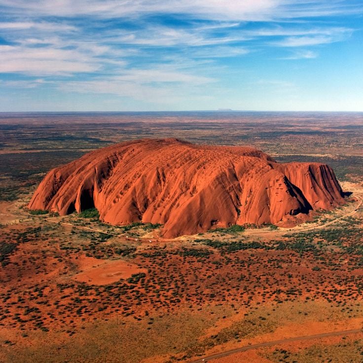
Uluru is a massive sandstone monolith rising 348 meters from the red desert floor in the heart of Australia, exemplifying the geological formations featured in this collection. The rock changes color throughout the day, shifting from reddish-orange to deep purple and crimson as the sun moves across the sky. The formation is sacred to the Anangu Aboriginal people, who have lived in this region for thousands of years. The base of the rock shows caves and water holes that provided shelter and drinking water. The surrounding landscape is flat desert with sparse vegetation adapted to the dry climate.
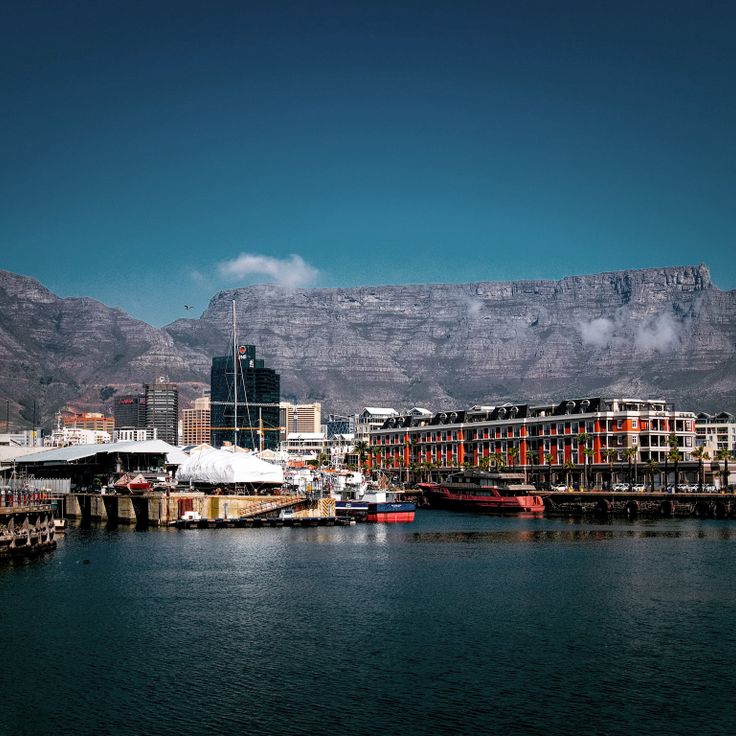
Table Mountain rises 1,086 meters above Cape Town, its flat top giving the mountain its distinctive name. This geological formation is part of a larger rocky range that shapes the landscape and overlooks the city below. A rotating cable car transports visitors to the summit, where views stretch across the coastline and surrounding mountain ranges. The rock face consists of sandstone layered in stacked formations. On cloudy days, mist rolls across the flat top like a tablecloth. Fynbos vegetation covers the slopes, featuring proteas and other flowering plants adapted to the local climate. Hikers traverse trails that climb the sides, passing through different plant communities. As part of Earth's geological story, Table Mountain demonstrates the layered rock formations created over millions of years.
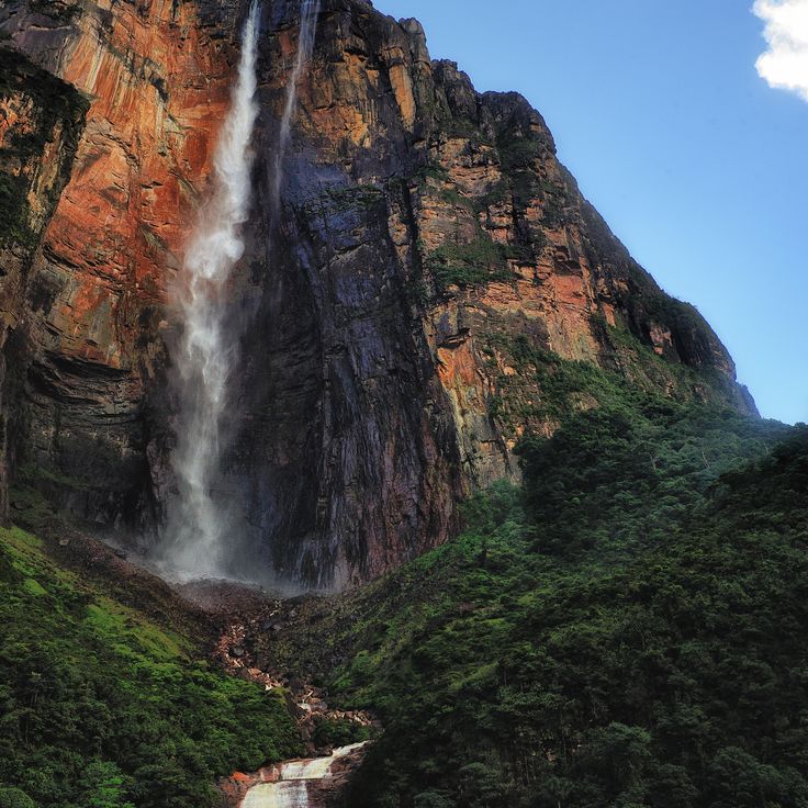
Angel Falls in Bolívar State is the world's highest uninterrupted waterfall, plunging 979 meters from the flat-topped mountain of Auyan Tepui into the Churun River below. The water falls from such a height that mist and spray break the flow into fragments before reaching the bottom. Located deep within a remote jungle, Angel Falls sits among ancient flat-topped mountains called tepuis that rise sharply from the surrounding forest. These formations are among the oldest rock structures on Earth and demonstrate how geological processes have shaped our world over millions of years. Reaching the falls requires a combination of boat travel and hiking through dense rainforest. The water flow changes with the seasons, appearing most powerful during the rainy months.
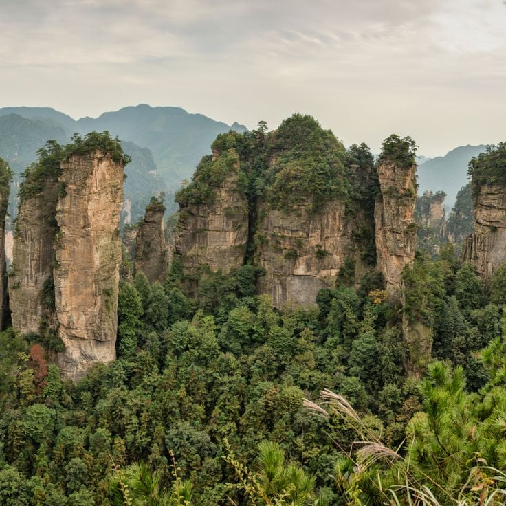
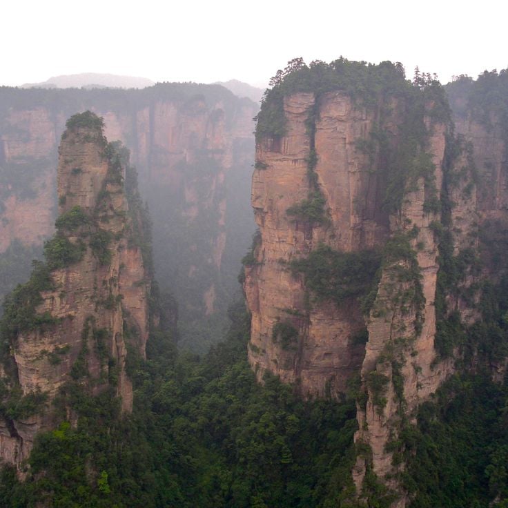
Zhangjiajie National Forest Park represents the diverse geological shapes that Earth develops over millions of years through weather and tectonic movement. Located in Hunan Province, China, the park contains thousands of tall, narrow quartz sandstone columns rising from the landscape. The tallest pillars exceed 200 meters in height. Mist and clouds frequently fill the valleys between the columns, creating an otherworldly appearance. Pathways and glass skywalk bridges connect the formations, allowing visitors to walk among them. Vegetation clings to the pillar sides and fills the valleys. These columns formed through geological processes operating over millions of years that carved through sandstone layers, leaving standing stone pillars behind.
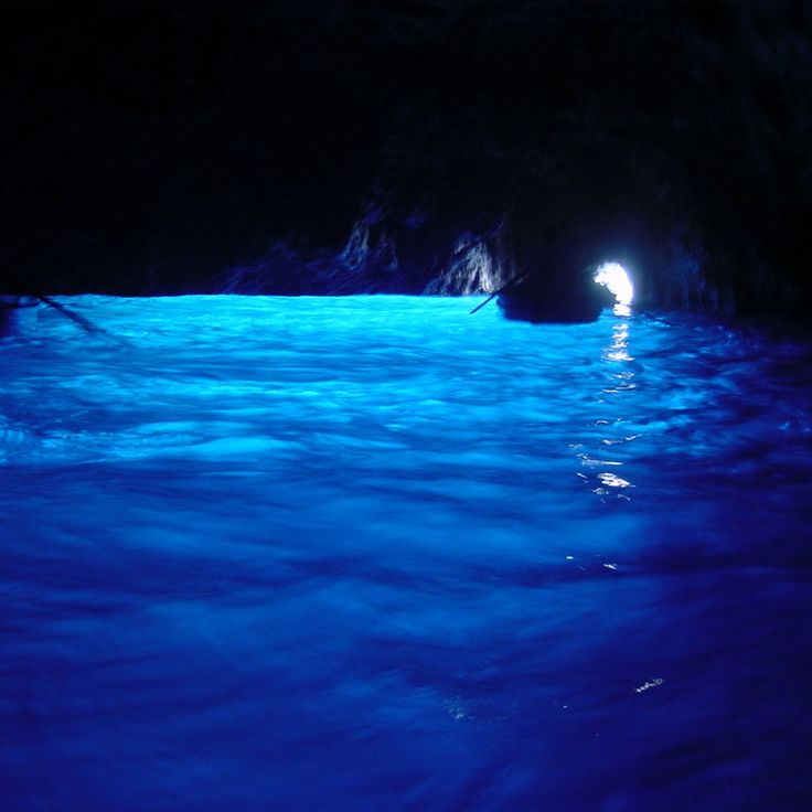
The Blue Grotto is a sea cave on Capri that shows how water and light shape limestone formations over millions of years. Sunlight enters through an underwater opening and fills the interior with intense blue light. The cave was formed by wave action and erosion of the rock. Visitors must lie down in small boats and pass through a narrow opening just above water level to enter. Inside, the blue light seems to come from the walls and water themselves. The effect is strongest on clear days when the sun shines directly. This grotto is one of Earth's geological wonders and has been part of Italian history for centuries.
Torres del Paine is a mountain range in southern Chile featuring three large granite peaks that rise sharply from the surrounding landscape. This place demonstrates the geological forces that have shaped the Earth over millions of years. The peaks stand about 2,500 meters high and dominate the vista across the Magallanes region. The larger protected area contains lakes, rivers and glaciers. The landscape shifts from grasslands to rocky slopes to snow-covered peaks. The granite formations show how tectonic forces pushed rock upward and erosion exposed the underlying stone. Hiking trails lead to viewpoints where visitors see the towers from different angles. The weather changes rapidly, with sun, wind, rain and clouds often appearing in the same day.
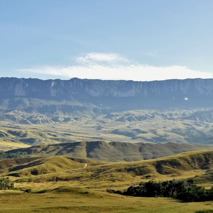
Mount Roraima is a table-top mountain at the border where Venezuela, Brazil and Guyana meet, standing as one of Earth's most distinctive geological formations shaped over millions of years. The flat summit holds its own ecosystem with plants and animals found nowhere else on the planet. Nearly vertical cliffs drop from the edges, with waterfalls cascading down the sides. The mountain's shape inspired Arthur Conan Doyle's novel The Lost World, and local indigenous peoples have considered it sacred for centuries.
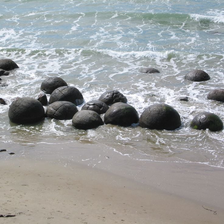
The Moeraki Boulders in Otago are enormous spherical rocks formed over millions of years. Minerals and sediment concentrated around a hard core to create these stones, each about 2 to 3 meters across. They sit on the beach and in shallow water, forming an unusual landscape that looks deliberately arranged but formed through slow natural processes. The beach is covered with dark sand containing volcanic minerals. Wind, water, and salt spray gradually weather the rocks, creating visible cracks on their surfaces. At high tide, the boulders rest in shallow water; at low tide, they sit on exposed sand.
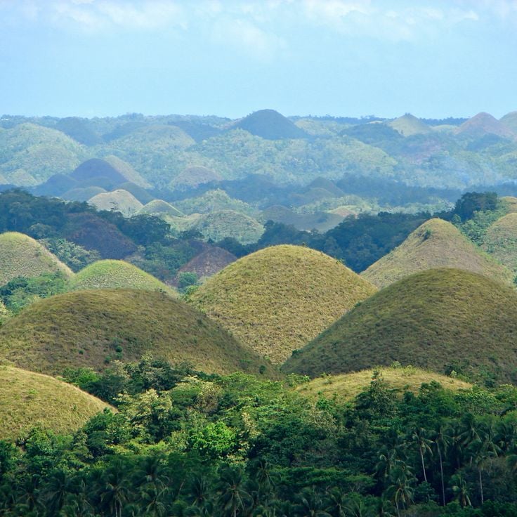
The Chocolate Hills in Bohol are part of Earth's varied geological story, shaped by limestone erosion over millions of years. These roughly 1,300 hills of limestone rise between 30 and 50 meters high, creating a regular pattern that becomes especially visible from elevated viewpoints. During the dry season, grass covering the hills turns brown, resembling chocolate, while the rainy season brings a green transformation. Between the hills lie flat lands where small communities have settled. The site is now protected as a national geological monument and draws visitors from around the world.
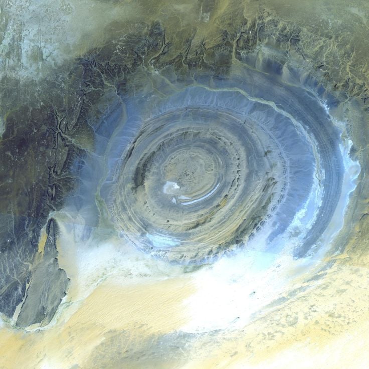
The Eye of the Sahara on the Adrar Plateau tells the story of Earth's geological forces in action. This circular formation reveals how erosion and the uplifting of rock layers create concentric rings visible from space. The structure sits in one of the harshest environments on Earth, where extreme temperatures shape the desert landscape. Few people reach this remote location due to its isolation, yet scientists continue to study how such a symmetrical pattern emerged from the combination of natural forces that have sculpted the Sahara over millions of years.
The Giant's Causeway tells the story of Earth's geology by showing how volcanic activity shaped the landscape over millions of years. These basalt columns in County Antrim formed around 60 million years ago when lava reached the surface and cooled into hexagonal shapes. About 40,000 columns rise along the coast, some reaching 12 meters (40 feet) high, and fit together like paving stones. You can walk on the flat tops at low tide. The basalt ranges in color from gray to reddish depending on light and moisture. Seabirds nest in the rock crevices, and waves crash against the lower formations.
The Grand Canyon is a large river valley carved by the Colorado River over millions of years into the high plateau of Arizona. The gorge runs roughly 450 kilometers (280 miles) through the desert landscape and displays layers of rock from different geological eras on its walls. Anyone standing at the rim looks down more than 1,000 meters (3,000 feet) to the river. Light shifts during the day and tints the cliffs from pale red through orange to violet. Trails lead from the upper plateau down to the water, past cacti and dry pines. The river itself has not finished its work and continues to dig into the rock, while rain and wind alter the shapes of the cliff faces. The Grand Canyon demonstrates how water, time, and movement of the land shape the Earth's surface in ways that take millions of years to unfold.
Valley of Dreams sits in northwestern New Mexico and displays gray and white hills made of petrified wood and mineral-rich sediments. This landscape formed from deposits left by rivers and lakes about 70 million years ago, when the region was a humid lowland. Wind and water have exposed the soft rock and shaped it into waves and cones. The petrified wood comes from trees that were buried by volcanic ash and replaced by silica. You walk on dry ground between formations that change color with the light.
Mount Everest represents the power of tectonic plate collisions in Earth's geological story. The mountain rises 8,849 meters (29,032 feet) above sea level as the tallest peak on the planet. Mount Everest formed millions of years ago when the Indian and Eurasian plates collided, a process still happening today as the landmasses continue to push against each other. From the Tibetan side, the summit looks like a sharp pyramid of rock and ice, while glaciers flow down the southern face in Nepal between steep cliffs. The air grows thin at this altitude, making breathing difficult without extra oxygen. The surrounding landscape is harsh and unforgiving, marked by extreme cold, strong winds, and deep crevasses.
The Great Barrier Reef extends along the coast of Queensland and stands as one of the largest structures created by living organisms. This coral reef contains thousands of individual coral blocks and islands in warm, shallow water. The coral gardens display many colors: pink, orange, purple and yellow. Fish, turtles and rays swim among the corals. Visitors travel by boat to snorkel or dive. The water is typically clear and turquoise. The corals grow slowly and remain sensitive to temperature changes.
The Salar de Uyuni is a salt flat on the Bolivian altiplano and represents one of Earth's remarkable geological formations shaped over millions of years. After rainfall, a thin layer of water covers the white surface and mirrors the sky above. During the dry season, the salt crust breaks into hexagonal patterns that spread across the level ground. A lake once covered this area, then evaporated and left behind thick deposits of salt and minerals. Cacti grow on islands made of volcanic rock, flamingos feed at shallow lagoons, and villages harvest salt from the ground. The air is dry, the sun strong under a clear sky, and the open space makes distances hard to judge.
Devil's Garden sits within Grand Staircase-Escalante National Monument and holds a landscape shaped by wind and water over millions of years. Red and orange sandstone rises from the ground, with narrow passages and natural arches carved by erosion. The arches appear as openings in the rock, forming passages you can walk through. The sandstone is soft and porous, allowing water to seep in and wear away material. Over time, cavities and cracks form. The surroundings are dry, vegetation is sparse, with only scattered desert plants growing among the rocks. Visitors move between rock formations that differ in color and shape. Some arches are wide and tall, others narrow and low. The terrain is uneven, the path crosses rock surfaces and sandy stretches.
The Yellowstone Caldera showcases one of North America's most active volcanic systems and serves as a key example of the geological forces that shape our planet. Beneath the surface lies a massive magma chamber, whose activity reveals itself through hot springs, geysers, and mudpots that constantly release steam and water. The ground rises and falls year after year, a sign that this system remains alive. The landscape shifts between forested hills and open valleys where sulfurous vapors rise into the air. Visitors walk along wooden boardwalks through fields where rock is stained orange, yellow, and green by mineral deposits. The heat beneath the ground influences all life at the surface. Three major eruptions over the past two million years have shaped this caldera. Scientists continuously monitor the volcanic activity to track changes.
The Wave is a sandstone formation made of Navajo rock laid down around 190 million years ago. Fine sand from ancient dunes hardened over time, leaving layers that now curve in ribbons of ochre, orange, and red. Wind and rain continue to shape the surface, bringing out the bands. Reaching The Wave requires a hike of about 6 kilometers (3.6 miles) across open ground with no marked trail, so visitors rely on GPS or a map. The sun beats down most of the day, and shade is rare. Daily visitor numbers are limited to protect the rock. The route crosses narrow slots and slickrock before arriving at the formation.
Kasha-Katuwe Tent Rocks National Monument displays volcanic ash layers shaped over six to seven million years into slender cone formations with pointed caps. Wind and water erosion wore away softer material faster than the harder protective rock at the tips, creating this distinctive pattern. The formations sit within a landscape of canyons and mesa plateaus in the New Mexico highlands. A trail passes through narrow slots between walls of banded tuff rock and gives views across the surrounding high desert. The layers show different shades from tan to gray that shift with changing light.
The Muddy Volcanoes of Buzău are part of Earth's geological formations, demonstrating how natural forces shape landscapes over millions of years. These mud volcanoes form when natural gas rises through layers of sediment and pushes mud to the surface. Small cones and craters emerge with gray bubbles coming from them. The terrain appears barren and resembles a lunar landscape. When it rains, the ground becomes a slippery mass. Activity is continuous but slow-moving. The mud is cool and contains minerals. The landscape is flat and surrounded by sparse vegetation.
Victoria Falls is a waterfall system that drops across a width of 1700 meters into a narrow gorge carved by the river over millions of years into the rock below. Water plunges 108 meters as the Zambezi River carries it over the edge in a dramatic flow. During the rainy season, the volume of water increases sharply, and the rising mist can be seen from several kilometers away. In the dry season, the river splits into several streams, and parts of the rock face become visible. The gorge continues to form through ongoing erosion as the falling water deepens the channel. Vegetation along the falls benefits from the constant moisture brought by the spray. On both sides of the gorge, paths run along the rock edge, offering views of the water's power and movement.
Antelope Canyon shows how water shaped sandstone over thousands of years. Narrow passages formed through erosion, while wind and rain polished the reddish walls. Smooth surfaces with wavy lines and curved shapes mark the landscape. Light enters through openings from above and casts changing colors on the rock. In some places, the passages are so tight that you need to squeeze between the walls. This canyon belongs to the geological formations that arise from the force of water in dry regions.
The Avenue of the Baobabs demonstrates how Earth's landscapes evolve over long periods. This tree-lined road lies west of Morondava and connects several villages across the plain. About a dozen baobab trees stand along an unpaved road surrounded by rice paddies and dry pastures. The trees belong to a species found only in Madagascar. Their trunks store water during the rainy season and can live for several hundred years. The road is used mostly at dusk by ox carts and people on foot. Some trees reach 100 feet (30 meters) in height.
The Jeita Grotto demonstrates the geological forces that have shaped the Earth over millions of years. This site consists of two interconnected limestone cave systems in the mountains north of Beirut. The lower cave contains an underground river flowing through large chambers accessible by boat. The upper cave can be explored on foot and displays stalactites and stalagmites in reddish and white tones. Water has deposited calcite over thousands of years, creating columns, draperies and pools. The Jeita Grotto also serves as a drinking water source for the region.
Along Bay displays how limestone transforms over millions of years through the action of water. More than 1600 islands and rock formations rise from the water, created by karst processes that shaped this landscape. The steep slopes of the islands support dense vegetation, while the water in the bay remains generally calm. Fishermen navigate small boats through the rocks, and caves become accessible when tides permit. This place demonstrates how geological forces continue to reshape the Earth's surface.
The Dead Sea represents one of Earth's most extreme geological phenomena and belongs in this collection of natural wonders. This body of water sits at the lowest point on Earth's surface, more than 1,300 feet (400 meters) below sea level. The water holds a salt concentration of around 34 percent, ten times higher than the ocean. Anyone who enters floats effortlessly at the surface. The shoreline is often lined with white salt crusts that glint in the sunlight. The surrounding landscape is barren, with dry hills and sparse vegetation. Almost no life survives in this water. The air down here is warm and thick, especially in summer. People come to coat themselves in the mineral-rich mud. The water evaporates constantly, so the surface has been shrinking for decades. The silence is notable, with no waves breaking the smooth expanse.
Meteora displays striking sandstone pillars that rise up to 400 meters above the Thessalian plain, part of a geological collection documenting Earth's diverse landforms shaped over millions of years. Six monasteries perched on these pillars date from the 14th and 15th centuries, forming one of Europe's most unusual religious complexes. Monks originally reached the summits using ladders and rope hoists. Today, staircases carved into the rock provide access. From the top, you look out over pine forests and fields below. The monasteries remain inhabited and house icons and frescoes from the late Middle Ages.
Wulingyuan Scenic Area displays more than 3,000 sandstone pillars rising up to 200 meters (656 feet) that formed through erosion over millions of years. The landscape features scattered rock formations in valleys and plateaus that resemble a natural maze. About 40 caves and two large natural bridges carved from the same sandstone cut through the terrain. Vegetation grows on the rocks and within crevices. Rivers and streams flow through the area, continuously shaping the stone. Mist and clouds frequently envelope the pillar tops and constantly change how the landscape appears. The caves offer glimpses into the inner layers of sandstone and reveal the geological story written in stone.
The Cliffs of Moher in County Clare represent the geological formations that shape Earth, built over millions of years through natural forces. These cliffs rise about 214 meters (700 feet) above the Atlantic and extend eight kilometers along Ireland's west coast. Wind has shaped the layers of shale and sandstone for thousands of years. Visitors walk on narrow paths near the edge while birds nest in large colonies on the steep rock faces. The 19th-century tower stands at one of the highest points and offers views across Galway Bay and the Aran Islands. On stormy days, spray reaches far up the cliffs as the ocean crashes directly against the rock. The landscape appears both bare and green at once, with grass growing right to the edge of the precipice.
These waterfalls at the border between Argentina and Brazil stretch across nearly 2 miles through subtropical rainforest. Hundreds of water streams drop between rock walls and forested islands. The Devil's Throat forms the heart of the site: a horseshoe-shaped chasm where water crashes down with a roar and creates a permanent mist cloud. Narrow walkways lead to the edge of the cascades, where moisture clings to the skin and rainbows appear in the spray. The Argentine side brings visitors close to the waterfalls, while the Brazilian side offers a wide view of the entire panorama. This geological formation demonstrates the power of water erosion over time.
This glacier represents one of Earth's geological wonders, showing how ice shapes landscapes over millions of years. The Perito Moreno Glacier stretches across the Andes and pushes into a lake, where its wall of bluish ice rises in places to around 240 feet (70 meters). The ice creaks, cracks and breaks off regularly, with large blocks crashing into the water with a deep rumble. From viewing platforms you can watch the mass slowly advance and shape itself through its own weight. Unlike many other glaciers in the region, this one does not retreat but holds its volume. The movement is visible, the ice seems alive. Visitor paths lead close to the front, some take guided walks on the surface. The cold, the light and the sound of falling ice blocks shape the place.
The Danxia formation in Gansu Province shows the geological processes that shaped the Earth over millions of years. Horizontal layers of sandstone stack upon one another, displaying bands ranging from red to yellow to orange. This coloring comes from different minerals, mainly iron oxide and other metal compounds that settled over time. Rain and wind have eroded the softer rock layers unevenly, creating wavy surfaces and grooves. The color contrasts become more visible as light changes throughout the day. This formation tells the story of Earth's geology and demonstrates how water and wind continue to reshape the landscape.
Mount Kilimanjaro is an inactive volcano in East Africa composed of three cones: Kibo, Mawenzi, and Shira. Its highest point reaches 19341 feet (5895 meters) above sea level. The upper reaches carry glaciers that have shrunk considerably over recent decades. The mountain's slopes display distinct vegetation zones, from tropical rainforest at the base to alpine desert at higher elevations. The volcano formed through tectonic activity in the East African Rift and has been dormant for around 150000 years. Its shape dominates the landscape far across the Tanzanian plateau, telling the story of Earth's geological forces.
Pamukkale is one of the geological formations that shape our planet. In southwestern Turkey, hot springs deliver mineral-rich water over limestone terraces, creating pools at different levels. As the water cools, it deposits calcium carbonate and forms white structures that look like cascading cotton or cauliflower. The water remains warm even in the lower pools. The white color comes from mineral deposits. Visitors walk barefoot across the upper terraces where shallow pools form. The contrast between the white limestone and the blue water creates a striking visual effect. The slopes below the plateau show how minerals have accumulated over thousands of years. The site has been used as a bathing place since ancient times.
Mount Fuji is a dormant volcano that demonstrates how volcanic activity shapes the Earth's geology. With a height of 3776 meters and its symmetrical cone shape, this mountain stands alone on the Kanto plain. The snow-capped peak is visible from Tokyo on clear days. The volcano's last eruption occurred in 1707. Lower slopes are covered with forests, while higher elevations have sparse vegetation. In winter, snow blankets the upper reaches and contrasts sharply with the dark volcanic rock. Hikers follow established routes to the summit, passing through different ecological zones that show how volcanic mountains create varied habitats.
Uluru is a massive sandstone monolith rising 348 meters from the red desert floor in the heart of Australia, exemplifying the geological formations featured in this collection. The rock changes color throughout the day, shifting from reddish-orange to deep purple and crimson as the sun moves across the sky. The formation is sacred to the Anangu Aboriginal people, who have lived in this region for thousands of years. The base of the rock shows caves and water holes that provided shelter and drinking water. The surrounding landscape is flat desert with sparse vegetation adapted to the dry climate.
Table Mountain rises 1,086 meters above Cape Town, its flat top giving the mountain its distinctive name. This geological formation is part of a larger rocky range that shapes the landscape and overlooks the city below. A rotating cable car transports visitors to the summit, where views stretch across the coastline and surrounding mountain ranges. The rock face consists of sandstone layered in stacked formations. On cloudy days, mist rolls across the flat top like a tablecloth. Fynbos vegetation covers the slopes, featuring proteas and other flowering plants adapted to the local climate. Hikers traverse trails that climb the sides, passing through different plant communities. As part of Earth's geological story, Table Mountain demonstrates the layered rock formations created over millions of years.
Angel Falls in Bolívar State is the world's highest uninterrupted waterfall, plunging 979 meters from the flat-topped mountain of Auyan Tepui into the Churun River below. The water falls from such a height that mist and spray break the flow into fragments before reaching the bottom. Located deep within a remote jungle, Angel Falls sits among ancient flat-topped mountains called tepuis that rise sharply from the surrounding forest. These formations are among the oldest rock structures on Earth and demonstrate how geological processes have shaped our world over millions of years. Reaching the falls requires a combination of boat travel and hiking through dense rainforest. The water flow changes with the seasons, appearing most powerful during the rainy months.
Zhangjiajie National Forest Park represents the diverse geological shapes that Earth develops over millions of years through weather and tectonic movement. Located in Hunan Province, China, the park contains thousands of tall, narrow quartz sandstone columns rising from the landscape. The tallest pillars exceed 200 meters in height. Mist and clouds frequently fill the valleys between the columns, creating an otherworldly appearance. Pathways and glass skywalk bridges connect the formations, allowing visitors to walk among them. Vegetation clings to the pillar sides and fills the valleys. These columns formed through geological processes operating over millions of years that carved through sandstone layers, leaving standing stone pillars behind.
The Blue Grotto is a sea cave on Capri that shows how water and light shape limestone formations over millions of years. Sunlight enters through an underwater opening and fills the interior with intense blue light. The cave was formed by wave action and erosion of the rock. Visitors must lie down in small boats and pass through a narrow opening just above water level to enter. Inside, the blue light seems to come from the walls and water themselves. The effect is strongest on clear days when the sun shines directly. This grotto is one of Earth's geological wonders and has been part of Italian history for centuries.
Torres del Paine is a mountain range in southern Chile featuring three large granite peaks that rise sharply from the surrounding landscape. This place demonstrates the geological forces that have shaped the Earth over millions of years. The peaks stand about 2,500 meters high and dominate the vista across the Magallanes region. The larger protected area contains lakes, rivers and glaciers. The landscape shifts from grasslands to rocky slopes to snow-covered peaks. The granite formations show how tectonic forces pushed rock upward and erosion exposed the underlying stone. Hiking trails lead to viewpoints where visitors see the towers from different angles. The weather changes rapidly, with sun, wind, rain and clouds often appearing in the same day.
Mount Roraima is a table-top mountain at the border where Venezuela, Brazil and Guyana meet, standing as one of Earth's most distinctive geological formations shaped over millions of years. The flat summit holds its own ecosystem with plants and animals found nowhere else on the planet. Nearly vertical cliffs drop from the edges, with waterfalls cascading down the sides. The mountain's shape inspired Arthur Conan Doyle's novel The Lost World, and local indigenous peoples have considered it sacred for centuries.
The Moeraki Boulders in Otago are enormous spherical rocks formed over millions of years. Minerals and sediment concentrated around a hard core to create these stones, each about 2 to 3 meters across. They sit on the beach and in shallow water, forming an unusual landscape that looks deliberately arranged but formed through slow natural processes. The beach is covered with dark sand containing volcanic minerals. Wind, water, and salt spray gradually weather the rocks, creating visible cracks on their surfaces. At high tide, the boulders rest in shallow water; at low tide, they sit on exposed sand.
The Chocolate Hills in Bohol are part of Earth's varied geological story, shaped by limestone erosion over millions of years. These roughly 1,300 hills of limestone rise between 30 and 50 meters high, creating a regular pattern that becomes especially visible from elevated viewpoints. During the dry season, grass covering the hills turns brown, resembling chocolate, while the rainy season brings a green transformation. Between the hills lie flat lands where small communities have settled. The site is now protected as a national geological monument and draws visitors from around the world.
The Eye of the Sahara on the Adrar Plateau tells the story of Earth's geological forces in action. This circular formation reveals how erosion and the uplifting of rock layers create concentric rings visible from space. The structure sits in one of the harshest environments on Earth, where extreme temperatures shape the desert landscape. Few people reach this remote location due to its isolation, yet scientists continue to study how such a symmetrical pattern emerged from the combination of natural forces that have sculpted the Sahara over millions of years.