See the monuments around you in AROpen chests in the app
Around Us is built for your phone — point your camera at the streets and discover the monuments and places around you in augmented reality.Around Us is built for your phone — chests unlock when you walk, explore and capture nearby places.
Wild Ardèche: between nature, ancient stones, and heritage
The Ardèche combines natural formations with centuries of human settlement. This southeastern French département stretches from the volcanic heights of the Cévennes to deeply carved limestone gorges along the river of the same name. The Pont d'Arc, a 197-foot (60-meter) natural stone arch, marks the entrance to the Gorges de l'Ardèche, while the Grotte Chauvet preserves cave paintings created 36,000 years ago. The landscape alternates between forested plateaus like the Bois de Païolive, where weathered limestone takes unusual shapes, and river valleys that have supported communities for centuries.
Several villages including Balazuc, Vogüé, and Labeaume cling to cliffsides above the water, their narrow lanes leading past castle ruins and Romanesque churches. The Cascade du Ray-Pic drops 197 feet (60 meters) over a basalt wall, while Mont Gerbier de Jonc holds the source of the Loire River. Beneath the surface, extensive cave systems include the Grotte de la Madeleine and the Aven d'Orgnac with its underground chambers. The Château de Crussol stands on a rocky outcrop above the Rhône valley, while the Château d'Aubenas dominates the town below. Between these natural and historical sites, the Train du Vivarais and the Vélorail des Gorges du Doux connect visitors to the region in practical ways.
This natural limestone arch marks the gateway to the Gorges de l'Ardèche and stands as one of the region's most recognized geological formations. The Ardèche River has carved through the rock over thousands of years, creating a span that reaches 177 feet (54 meters) in height and 197 feet (60 meters) in width. The Pont d'Arc is visible from both the riverbanks and the water itself, serving as the starting point for canoe trips through the gorges. The surrounding area offers hiking trails and swimming spots where visitors can grasp the scale of this formation.
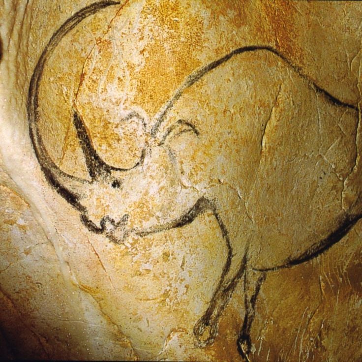
This cave was discovered in 1994 and preserves over a thousand paintings on its walls dating back 36,000 years. Bison, lions, bears – images from a vanished world that still impress with their vitality. The Grotte Chauvet contains some of the oldest known cave art created by humans and documents the artistic skill of our ancestors. Access to the original cave is restricted to protect the artwork, but a faithful replica, the Grotte Chauvet 2, allows visitors to experience the representations in their original arrangement. The replica was created with scientific precision and conveys an authentic impression of Ice Age art.
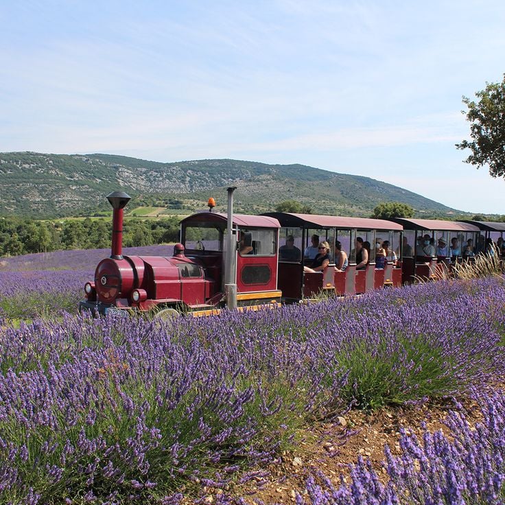
This museum in Saint-Remèze traces the history and cultivation of lavender, a plant grown in this region for generations. Visitors encounter historic distillation equipment, farming tools and explanations of traditional methods for producing essential oils. The exhibits detail lavender's economic role in the area and clarify the differences between lavender varieties and their applications. An outdoor section with flowering lavender fields complements the indoor displays. Located near the Gorges de l'Ardèche, the museum offers insight into an agricultural heritage that has shaped southern France.
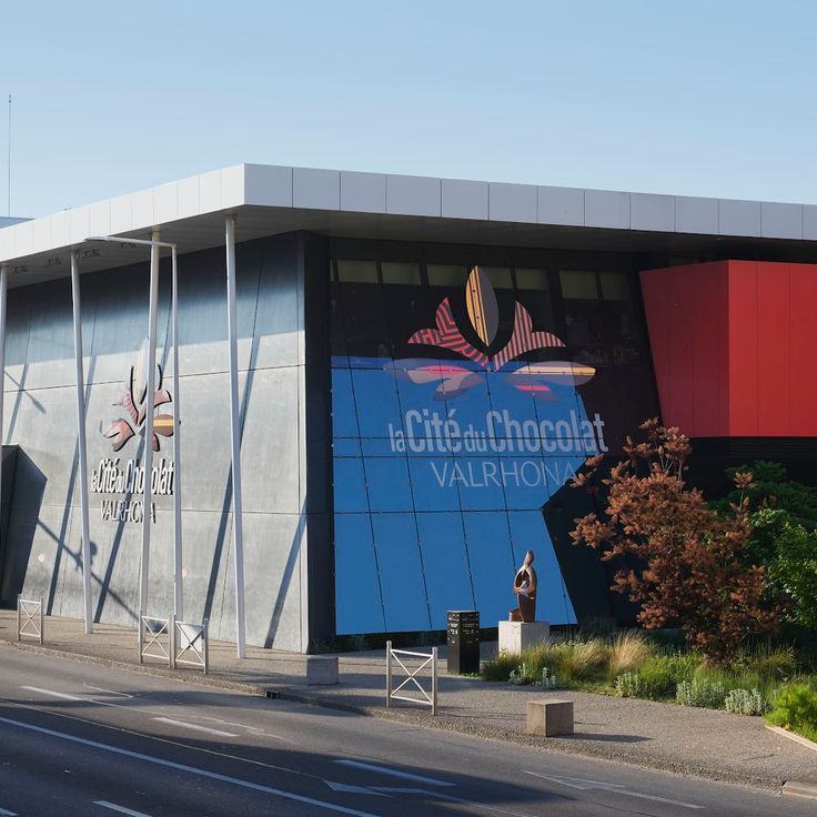
The Cité du Chocolat Valrhona walks visitors through the complete journey from cacao bean to finished product. This center in Tain-l'Hermitage presents manufacturing processes, ingredient origins, and flavor profiles through interactive exhibits. Tasting stations offer various chocolate types with different cacao percentages and regional sources. Workshops provide hands-on experience with techniques like tempering and molding. The museum combines technical knowledge with sensory exploration, making the complexity of chocolate production accessible to all ages.
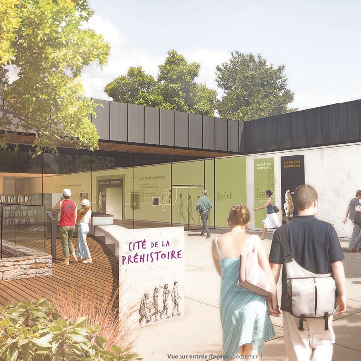
The Cité de la Préhistoire provides direct access to the prehistoric past of the Ardèche region. This museum displays archaeological finds spanning three millennia, from the Paleolithic through the Bronze Age. Exhibition rooms explain the development of human societies through tools, pottery and skeletal remains recovered from local excavations. Interactive stations demonstrate techniques such as fire-making and stone-working. The research center collaborates with regional archaeological sites and regularly updates its collections. A visit takes about two hours and pairs well with the nearby Aven d'Orgnac, one of the largest caves in southern France.
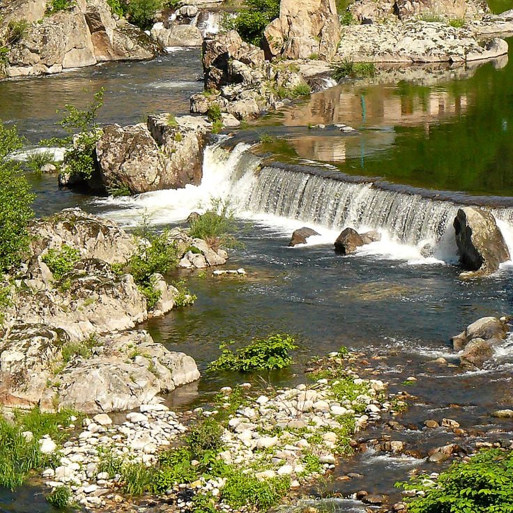
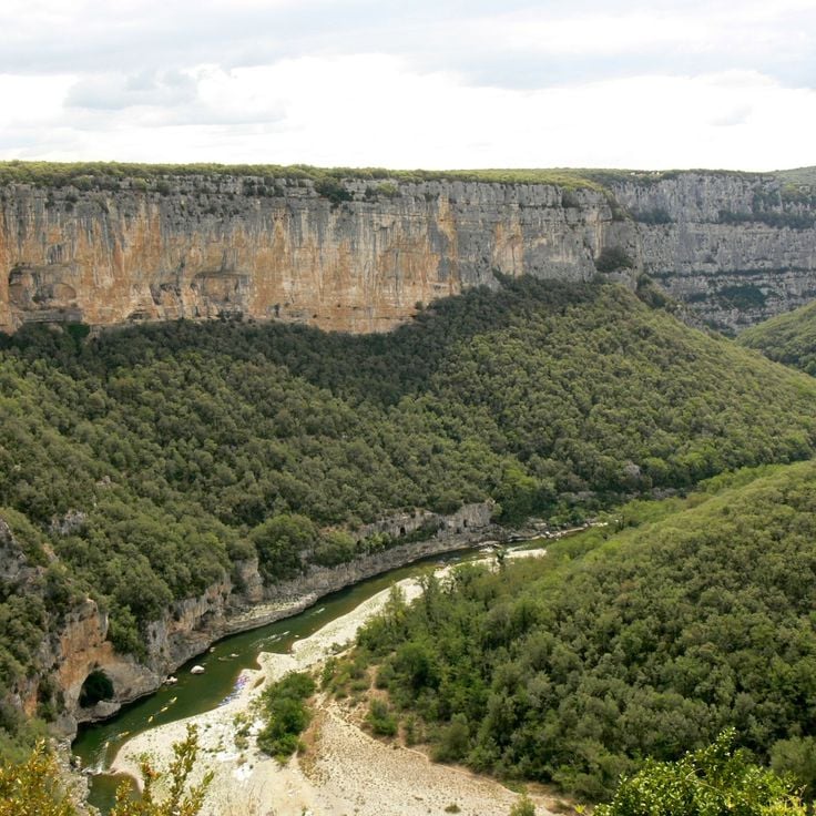
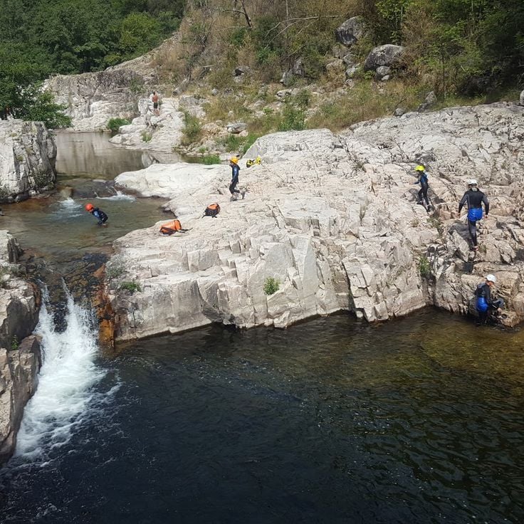
The Gorges de l'Ardèche form a limestone canyon carved by the Ardèche River over 19 miles (30 kilometers) between Vallon-Pont-d'Arc and Saint-Martin-d'Ardèche, with cliffs reaching up to nearly 1,000 feet (300 meters) in height. The gorge features numerous viewpoints along a winding scenic road that follows the river's course. Visitors can explore the gorge on foot, by canoe, or by bicycle, with the river offering paddling routes during summer months and marked hiking trails running through the limestone formations.
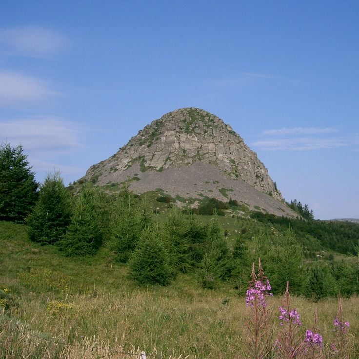
Mont Gerbier de Jonc is a 5089-foot (1551-meter) volcanic peak in the southern Massif Central, rising from the plateau with its distinctive phonolite dome. Three springs at its base mark the source of the Loire River, which begins its 620-mile (1000-kilometer) journey to the Atlantic from this point. The summit trail takes about 45 minutes through moorland and offers views across the volcanic ranges of Ardèche. The mountain's steep conical shape comes from phonolite, an uncommon volcanic rock that formed during ancient eruptions. A small museum near the parking area explains the site's hydrological significance and the mountain's geological history.
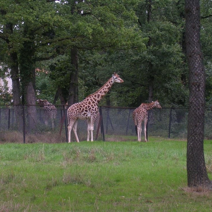
This zoological park covers 80 hectares (198 acres) and houses around 1,200 animals representing 128 different species. Safari de Peaugres offers two ways to explore: a walking trail through themed areas featuring primates, predators and birds, and a driving circuit several miles long where visitors observe giraffes, lions, bears and other large animals from their own vehicles. Located on the edge of Ardèche, the park combines conservation efforts with practical education programs. Families will find playgrounds, picnic areas and several daily feeding sessions with commentary at various animal exhibits.
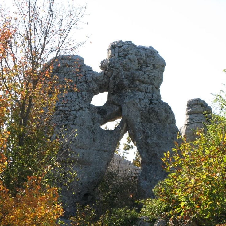
The Bois de Païolive stretches across 6 square miles (16 square kilometers) of white oak forest and limestone formations carved by erosion into natural labyrinths. Wind and water have shaped the rocks into forms resembling animals, buildings, or abstract sculptures. Marked trails guide visitors through this forested landscape where light and shadow shift between twisted trees and gray stone blocks. The terrain requires sturdy footwear and a sense of direction, as paths sometimes fork between the rocks. The combination of Mediterranean vegetation and geological formations makes this forest a place where nature and time work together in visible ways.
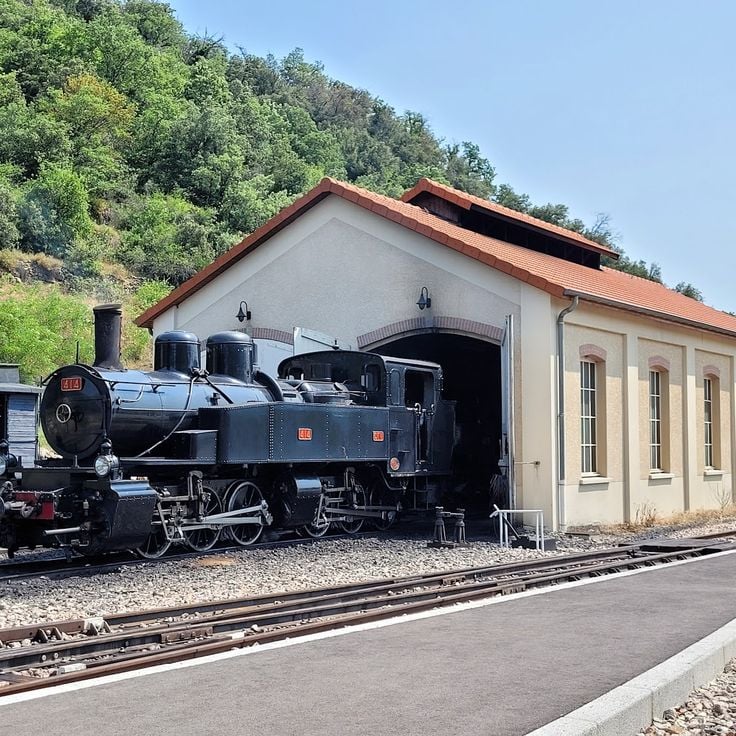
Between Saint-Jean-de-Muzols and Lamastre, this historic steam train works its way through the Doux Valley. The Train du Vivarais covers 21 miles (33 kilometers) on a narrow gauge line built in the early 1900s, crossing viaducts and tunneling through rock as it connects two villages in the Ardèche backcountry. The locomotive burns coal and emits black smoke and rhythmic whistles that echo off the valley walls. Passengers ride in vintage carriages through forested slopes and past riverbanks, experiencing rail travel as it was more than a century ago. The journey takes about two hours each way and offers a practical look at regional history and terrain from an angle you cannot get by car.
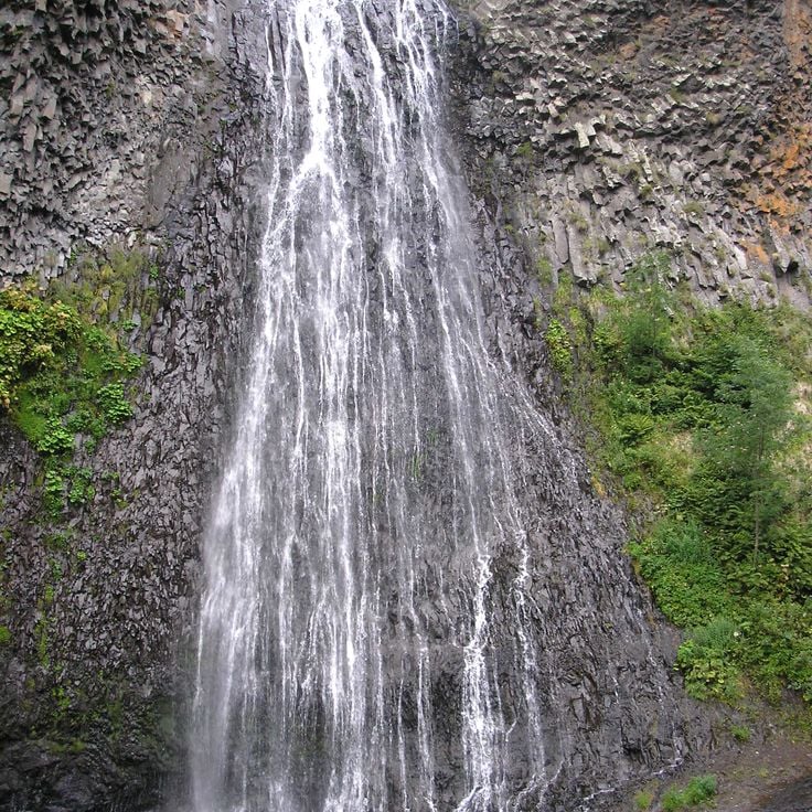
This waterfall drops 200 feet (60 meters) over a wall of basalt columns formed by ancient volcanic activity. The Ray-Pic is reached by a short forest trail and marks a dramatic point where the Bourges River tumbles over solidified lava. The geometric columns and the roar of the water create an unusual scene in this remote corner of the Ardèche. A visit takes about an hour, longer if you explore the surrounding trails.
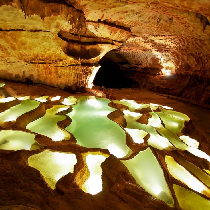
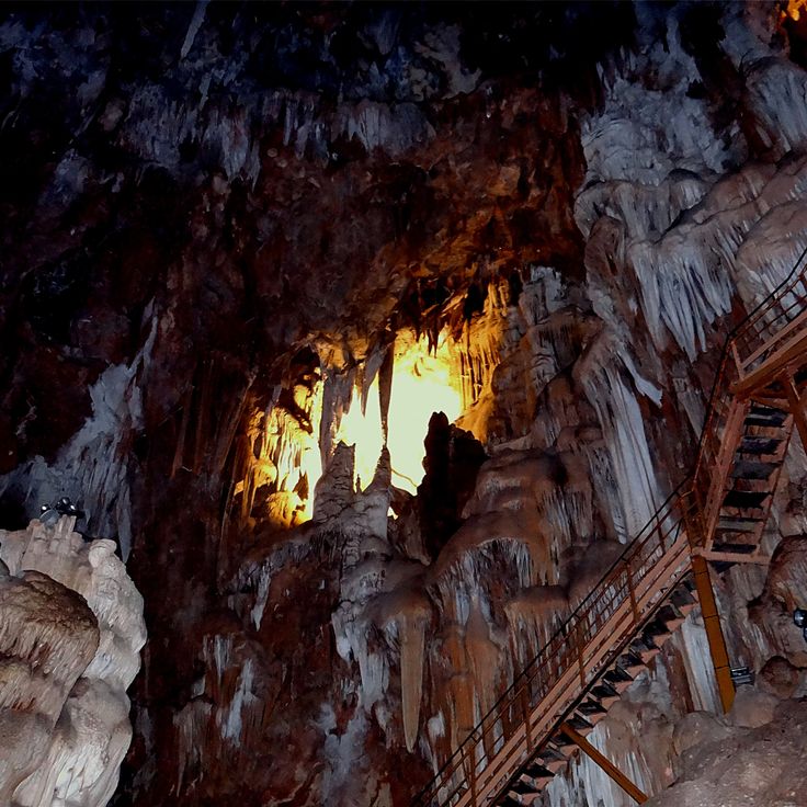
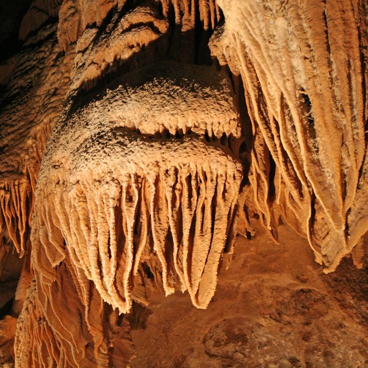
The Grotte de la Cocalière extends for about three fifths of a mile (1 kilometer) beneath the surface, displaying a sequence of limestone formations shaped over thousands of years. The tour moves through several chambers filled with stalactites, stalagmites and flowing stone curtains, alongside an underground river. Sections of the network contain prehistoric traces indicating early human presence. Access is by guided tour only, lasting around an hour through lit passages. The circuit concludes with a short ride on a small train covering the final stretch back to the exit. Interior climate remains steady year round at approximately 57 degrees Fahrenheit (14 degrees Celsius).
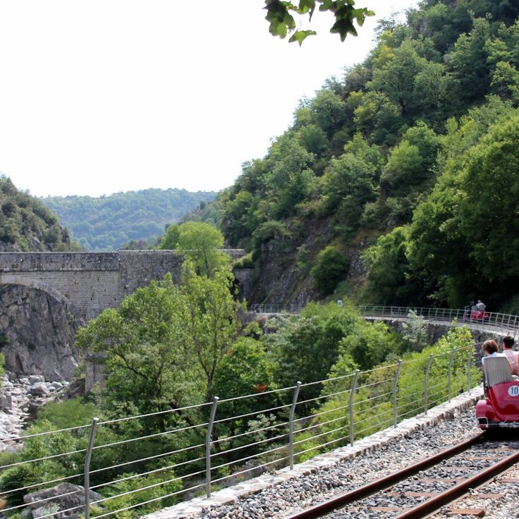
This rail bike operates on a former railway line along the Doux Gorges, offering four different routes ranging from 5 to 12.4 miles (8 to 20 kilometers) in length. The track runs through the wooded river valley, combining physical activity with access to the natural landscape. The ride follows original rails that once served freight transport, providing an unconventional way to experience the region's terrain. The Vélorail des Gorges du Doux connects the history of local rail infrastructure with a practical approach to exploring the Doux Valley.
The ruins of Château de Crussol stand on a rocky promontory 1,300 feet (400 m) above the Rhône Valley, documenting the strategic vision of medieval builders. Built in the 12th century, this fortress once controlled trade routes between the Rhône corridor and the Massif Central. Today the remaining walls, towers and vaulted chambers testify to the military engineering of that era. The climb through Mediterranean scrubland leads to remnants of watchtowers, living quarters and cisterns. From the ruins, views extend across the Rhône Valley, the Ardèche plateaus and on clear days toward Mont Blanc. The site demonstrates how natural topography and human construction merged to create one of the region's most important fortifications.
Balazuc is a medieval village dating from the 11th century, built on a rocky outcrop above the Ardèche River. The fortified settlement preserves its keep, castle and narrow cobbled lanes that wind between stone houses. The elevated position provided protection for centuries and now offers wide views over the river valley. Like many sites in the region, Balazuc shows how people adapted to the rocky terrain, integrating their buildings into the cliffs. The village is one of the historic settlements that define the cultural heritage of the Ardèche, where nature and architecture have intertwined since the Middle Ages.
The Balmes de Montbrun are a network of dwellings carved into volcanic rock, documenting human occupation since the Middle Ages. These cave homes, cut into the cliff face of the Coiron plateau, reflect centuries of adaptation to the Ardèche landscape. The site includes multiple levels of chambers hewn directly from porous basalt, which once served as permanent residences. The location offers insight into traditional building techniques and how residents utilized the natural properties of volcanic stone. The Balmes sit within a region known for its geological diversity, fitting into the mosaic of natural heritage and historic settlements that defines the Ardèche.
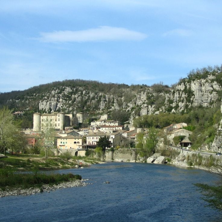
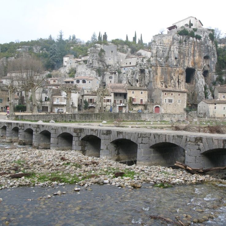
Vogüé clings to the side of a steep limestone outcrop, a medieval village where stone houses press against the walls of an 11th-century château. Narrow lanes wind between dwellings linked by vaulted passageways, connecting different levels of the village that was ruled for centuries by the Lords of Vogüé. The château, rebuilt several times over, dominates the scene from its rocky perch while stone terraces open toward the water at the riverbank. Located at the foot of the Ardèche, the village offers direct access to the river gorges downstream and the wooded limestone plateaus above.
This cave extends across 35 miles (57 kilometers) of underground passages, linking limestone formations with geological history. Guided tours reveal calcite deposits, natural pools and concretions that formed over millennia. The accessible section offers insight into the processes that shaped the Ardèche plateau. Visitors follow marked paths through lit chambers, where guides explain the formation of stalactites and stalagmites and the role of water in carving the limestone.
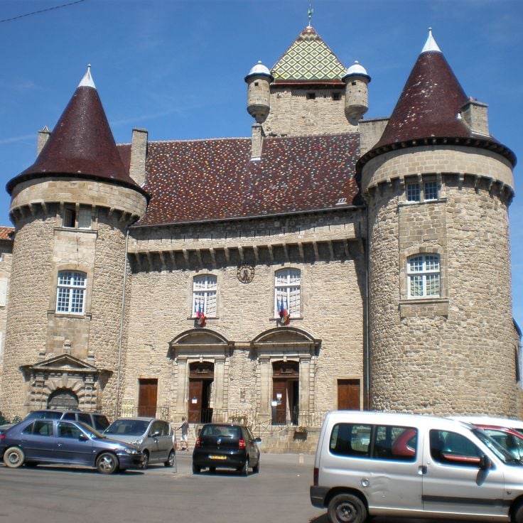
The Château d'Aubenas sits above the town and provides insight into the region's medieval architecture. Built in the 12th century, this fortress underwent modifications over the centuries and now displays elements from different periods. Visitors explore the guard room, decorated chambers and climb the tower for a panorama across the Ardèche valley. The castle serves as a cultural center with rotating exhibitions and documents the history of this area between the Cévennes and the Rhône valley.
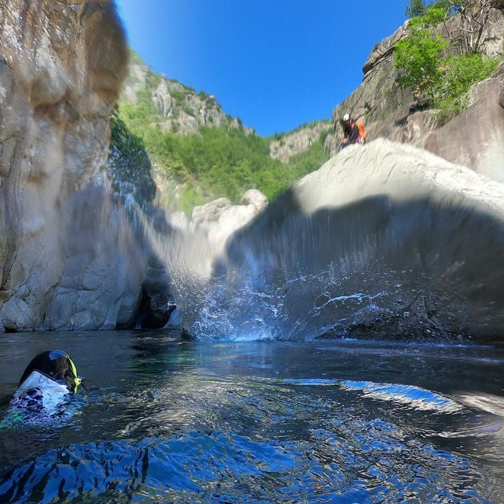
These limestone gorges follow the Beaume River for 20 miles (32 kilometers), connecting the village of Joyeuse with the Ardèche River near Ruoms. The D24 road runs along the watercourse between steep rock walls rising up to 490 feet (150 meters). Several hiking trails start from parking areas along the route, providing access to the riverbank, gravel beaches and viewpoints above the gorge. The Beaume flows year-round, including during summer, and offers natural pools suitable for swimming among the rocks. In winter, the road typically remains open, though the water runs higher.
Pont du Diable is a medieval stone bridge spanning the Ardèche River near Thueyts. The arch crosses the river where basalt formations line the banks. Built in the 13th century, the bridge once connected isolated villages on the plateau. From Pont du Diable, you see the black columns of cooled lava rock rising from the riverbed. A footpath leads down to the water and offers views of the structure from below. The bridge still carries foot traffic today and provides access to several routes along the Ardèche.
The Gorges du Chassezac cut through the landscape south of Les Vans, where the river flows between rock walls that rise up to 400 feet (120 meters) in some sections. The valley provides access to several swimming spots along the river, where clear water runs over flat rock slabs. Climbing routes of varying difficulty follow the steep limestone walls, while hiking trails trace the course of the gorge and lead to viewpoints overlooking the wooded slopes and the winding watercourse. The Gorges du Chassezac belong to the less crowded gorges of the Ardèche and combine geological formations with opportunities for outdoor activities.
The Château d'Alba la Romaine rises above the remains of the Roman settlement of Alba Helviorum, embodying the layers of Ardèche history. Built in the 11th century, this fortress with its square central tower formed the center of medieval power in a region where stone villages cling to rock faces and history lives in every wall. The facade preserves decorative paintings, while the interior rooms display furnishings and features from various periods. From its walls, views extend across the valley where Romans, feudal lords and farmers have succeeded one another over centuries. This site connects the warm stones of Ardèche with its long human occupation, a testament to the continuity that defines the department between nature and built heritage.
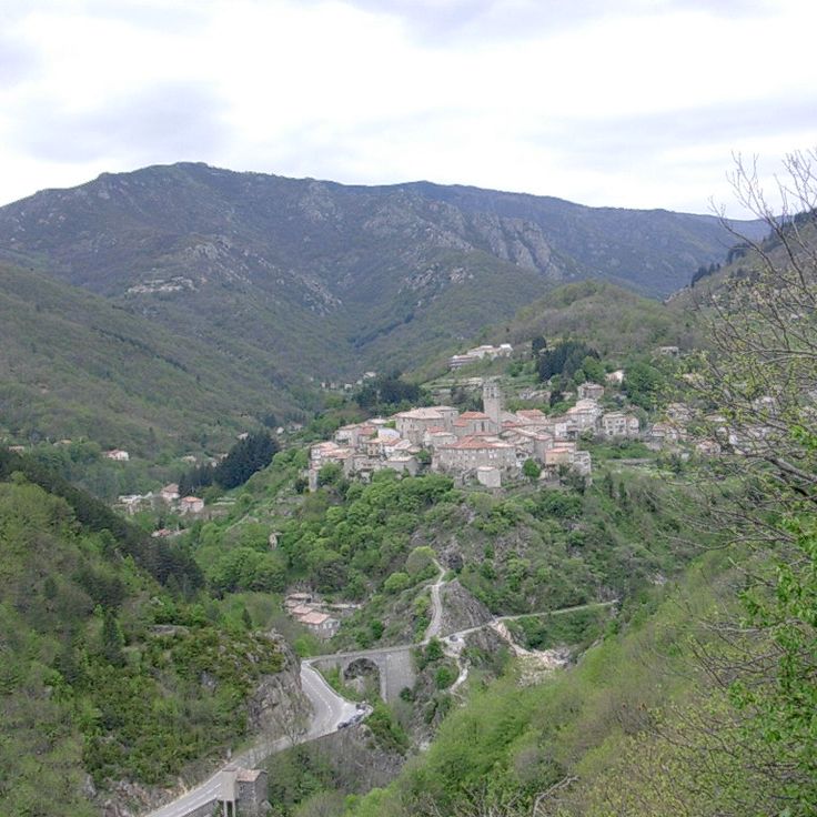
Antraigues-sur-Volane sits at 1,540 feet (470 meters) on the slopes of an extinct volcano. The village has preserved narrow lanes built from basalt stone that wind between houses with dark facades. Along the pathways and on building walls, visitors find over one hundred faces carved into volcanic rock by local sculptors. A Romanesque church stands above the central square. From several vantage points, views extend across the forested valleys of the Ardèche and surrounding mountains. The village was home to singer Jean Ferrat for many years and attracts those interested in walking through historic lanes and discovering the stonework scattered throughout.
The Aven Marzal is a cave system with three levels of underground galleries, accessed by staircases and equipped with lighting. The geological chambers display calcite formations, stalactites and stalagmites that illustrate the slow work of water through limestone. The site also includes a paleontological museum housing fossil finds from the region, offering a concrete view of the geological history of the Ardèche. Visits follow a secured route and last approximately one hour.
Labeaume dates to the 12th century and sits on a limestone cliff above the Beaume River. The lanes are narrow, the houses built from stone, the colors earthy. The village once served as a stop for traders and travelers, and today it draws hikers exploring the Beaume Valley or the Gorges de l'Ardèche. In summer, locals and visitors swim in the river, where the water runs clear and cool. From the village, several marked trails lead into surrounding forests and to the limestone cliffs that rise above the valley. The church of Saint-Pierre-aux-Liens stands on a rocky outcrop and offers views over the valley. The area is part of the Monts d'Ardèche regional nature park.
This natural cave, opened to the public in 1969, sits above the Ardèche Gorge and ranks among the largest accessible cave systems in the region. The Grotte de la Madeleine extends through several underground chambers, where limestone formations such as stalactites, stalagmites and columns appear in various stages of development. The marked route leads through galleries with ceilings reaching up to 131 feet (40 meters), past draperies and speleothems formed by thousands of years of calcium carbonate dissolution and deposition. The guided tour lasts about an hour. At the exit, a wide view opens over the wooded plateau and the limestone cliffs of the surrounding area.
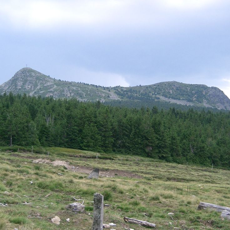
Mont Mézenc rises as the highest peak in the Monts d'Ardèche at 5,751 feet (1,753 meters), marking the border between Ardèche and Haute-Loire. This extinct volcano of phonolite rock shapes the landscape with its characteristic formations and forms the watershed between the Atlantic and Mediterranean. Several hiking trails lead to the summit, including the GR 7, from where a clear day reveals views across the Massif Central to the Alps. The plateau surrounding this mountain contains flora typical of the elevation and lies within a protected natural area that preserves the volcanic past of the region.
The MuséAl in Alba-la-Romaine guides visitors through the Roman past of the region, displaying artifacts recovered from excavations at Alba Helviorum. The permanent collection includes pottery, coins, tools and architectural fragments that document daily life in this Gallo-Roman settlement. The museum complements a visit to the nearby ancient site and offers a tangible understanding of the Roman presence in the Ardèche, away from major tourist routes.
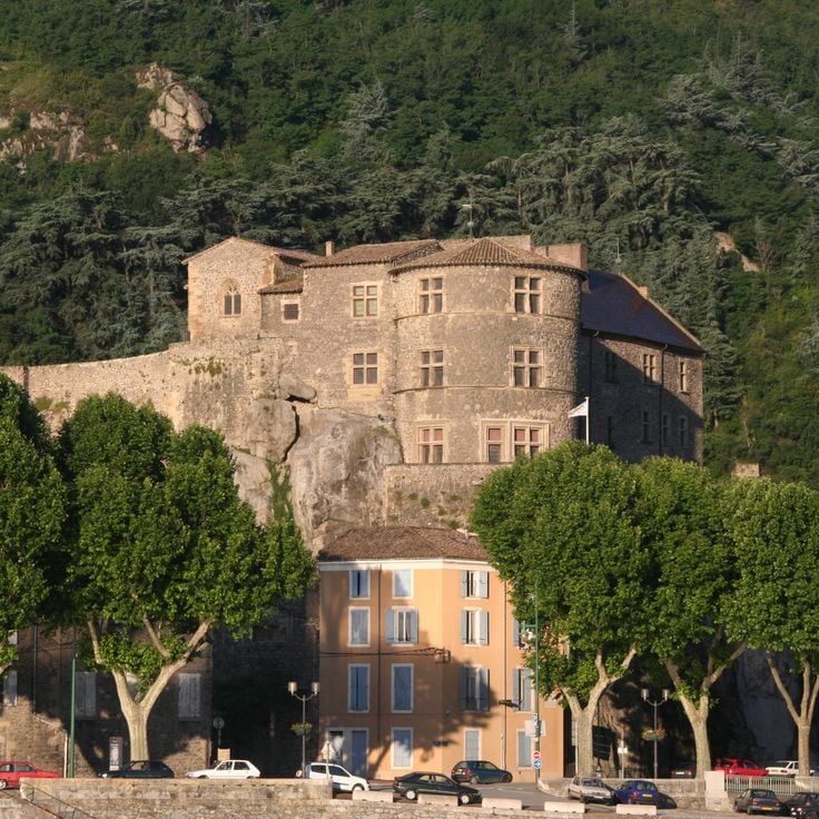
This medieval castle now houses a museum whose rooms on two floors document the region's history. The upper levels offer direct views over the Rhône Valley. The building itself shows construction phases from the 14th through 16th centuries. Inside, archaeological finds, historical documents and objects from daily life of past centuries are displayed. Its riverside location makes the Château de Tournon a recognizable landmark in this part of Ardèche.
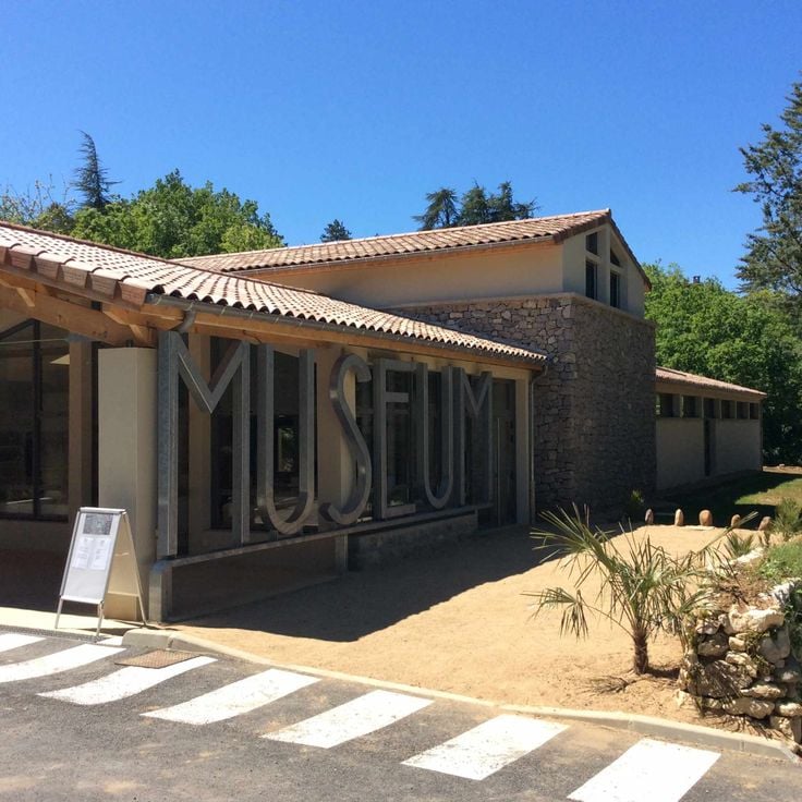
The Muséum de l'Ardèche displays a collection of fossils discovered in the region across 2,150 square feet (200 square meters), including marine and terrestrial specimens from various geological periods. The exhibition documents the history of this landscape, which was covered by seas millions of years ago before tectonic forces shaped it. Visitors see fossilized shells, ammonites and other evidence of past life forms discovered in the limestone layers of the Ardèche. The museum is located in Balazuc, one of the characteristic stone villages on the edge of the Gorges de l'Ardèche, where the geological past remains readable in the surrounding rock formations.
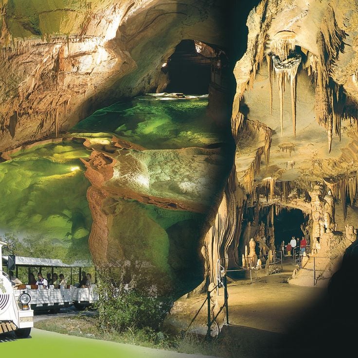
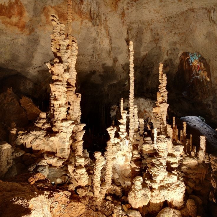
This cave descends through a series of underground galleries on multiple levels, displaying limestone formations built over thousands of years. The Aven d'Orgnac alternates vast chambers with stalactites, stalagmites and hanging formations that give scale and time a physical presence. Visitors follow a developed path that winds down and loops through several rooms, some reaching extraordinary heights of around 160 feet (50 meters). A prehistory museum on the site above complements the visit, presenting findings from settlements and caves across the region. This location ranks among the significant natural spaces of the Ardèche and offers insight into the work of water beneath the surface.
This museum in Cruas dedicates 2,700 square feet (250 m²) to the history and evolution of sports. The collection displays historic and contemporary sporting equipment across various disciplines and includes interactive simulation areas where visitors can engage directly. The exhibition combines documentary elements with hands-on experiences, making the development of athletic practices and technologies accessible. Located in Cruas, a town in the southern Ardèche, the museum complements the regional offering between nature exploration and cultural heritage by focusing on movement and physical activity.
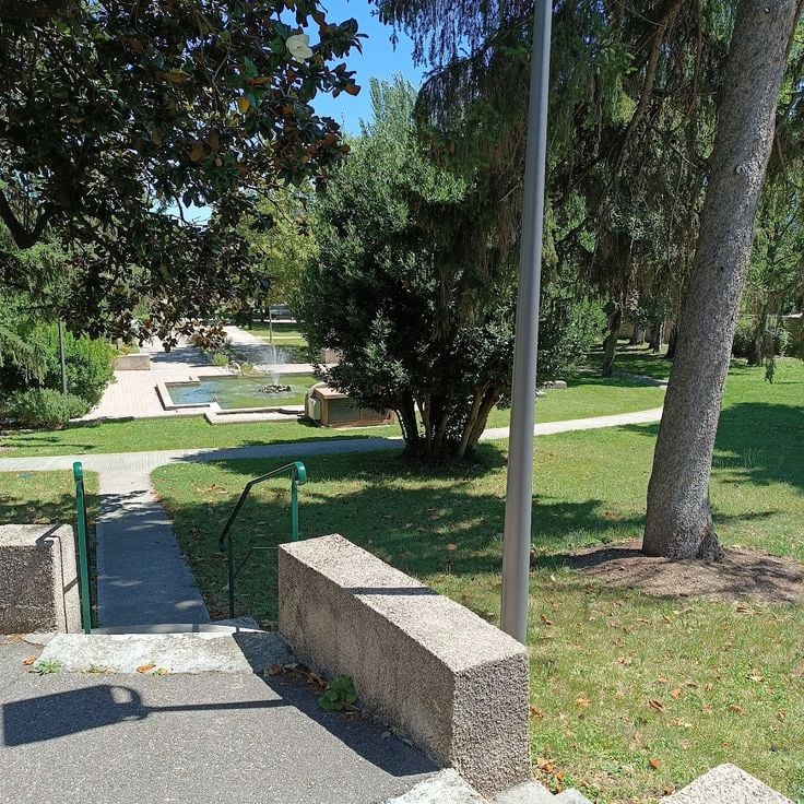
Vals-les-Bains is a spa town with a long tradition of hydrotherapy. The naturally carbonated mineral springs have been used for therapeutic purposes since the 17th century. The thermal center offers various treatments based on the mineral properties of the local springs. The town sits in a narrow valley and combines bathing culture with the Ardèche landscape. Several springs are accessible to the public, allowing visitors to taste the water directly. The historical development as a spa town has shaped the architecture and character of the place.
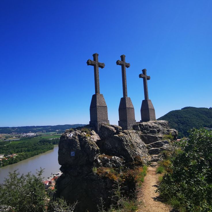
This mountain trail climbs through wooded terrain to a viewpoint above Andance, offering views across the Rhône Valley and the Vivarais hills. The ascent follows mixed forest paths and rocky sections that bridge the elevation gain between the village and the summit. At the top, the landscape opens to reveal the river plain, the opposite slopes and the layout of the middle Rhône corridor. The three crosses mark the highest point of the hike and have served as landmarks for walkers and pilgrims for generations. The descent can follow the same route or take alternative paths through vineyards and terraced cultivation back to the village.
The Eyrieux Valley cuts through the Ardèche over 28 miles (45 kilometers), following a former railway line now converted into a cycling and walking path. The route connects La Voulte-sur-Rhône to Le Cheylard, offering a paved trail through forests, alongside the river and past villages. Gradients remain gentle, and old train stations have been repurposed as rest stops. This corner of the Ardèche reveals a quieter side of the region, less dramatic than the Gorges but equally tangible in its history and landscape.
This natural limestone arch marks the gateway to the Gorges de l'Ardèche and stands as one of the region's most recognized geological formations. The Ardèche River has carved through the rock over thousands of years, creating a span that reaches 177 feet (54 meters) in height and 197 feet (60 meters) in width. The Pont d'Arc is visible from both the riverbanks and the water itself, serving as the starting point for canoe trips through the gorges. The surrounding area offers hiking trails and swimming spots where visitors can grasp the scale of this formation.
This cave was discovered in 1994 and preserves over a thousand paintings on its walls dating back 36,000 years. Bison, lions, bears – images from a vanished world that still impress with their vitality. The Grotte Chauvet contains some of the oldest known cave art created by humans and documents the artistic skill of our ancestors. Access to the original cave is restricted to protect the artwork, but a faithful replica, the Grotte Chauvet 2, allows visitors to experience the representations in their original arrangement. The replica was created with scientific precision and conveys an authentic impression of Ice Age art.
This museum in Saint-Remèze traces the history and cultivation of lavender, a plant grown in this region for generations. Visitors encounter historic distillation equipment, farming tools and explanations of traditional methods for producing essential oils. The exhibits detail lavender's economic role in the area and clarify the differences between lavender varieties and their applications. An outdoor section with flowering lavender fields complements the indoor displays. Located near the Gorges de l'Ardèche, the museum offers insight into an agricultural heritage that has shaped southern France.
The Cité du Chocolat Valrhona walks visitors through the complete journey from cacao bean to finished product. This center in Tain-l'Hermitage presents manufacturing processes, ingredient origins, and flavor profiles through interactive exhibits. Tasting stations offer various chocolate types with different cacao percentages and regional sources. Workshops provide hands-on experience with techniques like tempering and molding. The museum combines technical knowledge with sensory exploration, making the complexity of chocolate production accessible to all ages.
The Cité de la Préhistoire provides direct access to the prehistoric past of the Ardèche region. This museum displays archaeological finds spanning three millennia, from the Paleolithic through the Bronze Age. Exhibition rooms explain the development of human societies through tools, pottery and skeletal remains recovered from local excavations. Interactive stations demonstrate techniques such as fire-making and stone-working. The research center collaborates with regional archaeological sites and regularly updates its collections. A visit takes about two hours and pairs well with the nearby Aven d'Orgnac, one of the largest caves in southern France.
The Gorges de l'Ardèche form a limestone canyon carved by the Ardèche River over 19 miles (30 kilometers) between Vallon-Pont-d'Arc and Saint-Martin-d'Ardèche, with cliffs reaching up to nearly 1,000 feet (300 meters) in height. The gorge features numerous viewpoints along a winding scenic road that follows the river's course. Visitors can explore the gorge on foot, by canoe, or by bicycle, with the river offering paddling routes during summer months and marked hiking trails running through the limestone formations.
Mont Gerbier de Jonc is a 5089-foot (1551-meter) volcanic peak in the southern Massif Central, rising from the plateau with its distinctive phonolite dome. Three springs at its base mark the source of the Loire River, which begins its 620-mile (1000-kilometer) journey to the Atlantic from this point. The summit trail takes about 45 minutes through moorland and offers views across the volcanic ranges of Ardèche. The mountain's steep conical shape comes from phonolite, an uncommon volcanic rock that formed during ancient eruptions. A small museum near the parking area explains the site's hydrological significance and the mountain's geological history.
This zoological park covers 80 hectares (198 acres) and houses around 1,200 animals representing 128 different species. Safari de Peaugres offers two ways to explore: a walking trail through themed areas featuring primates, predators and birds, and a driving circuit several miles long where visitors observe giraffes, lions, bears and other large animals from their own vehicles. Located on the edge of Ardèche, the park combines conservation efforts with practical education programs. Families will find playgrounds, picnic areas and several daily feeding sessions with commentary at various animal exhibits.
The Bois de Païolive stretches across 6 square miles (16 square kilometers) of white oak forest and limestone formations carved by erosion into natural labyrinths. Wind and water have shaped the rocks into forms resembling animals, buildings, or abstract sculptures. Marked trails guide visitors through this forested landscape where light and shadow shift between twisted trees and gray stone blocks. The terrain requires sturdy footwear and a sense of direction, as paths sometimes fork between the rocks. The combination of Mediterranean vegetation and geological formations makes this forest a place where nature and time work together in visible ways.
Between Saint-Jean-de-Muzols and Lamastre, this historic steam train works its way through the Doux Valley. The Train du Vivarais covers 21 miles (33 kilometers) on a narrow gauge line built in the early 1900s, crossing viaducts and tunneling through rock as it connects two villages in the Ardèche backcountry. The locomotive burns coal and emits black smoke and rhythmic whistles that echo off the valley walls. Passengers ride in vintage carriages through forested slopes and past riverbanks, experiencing rail travel as it was more than a century ago. The journey takes about two hours each way and offers a practical look at regional history and terrain from an angle you cannot get by car.
This waterfall drops 200 feet (60 meters) over a wall of basalt columns formed by ancient volcanic activity. The Ray-Pic is reached by a short forest trail and marks a dramatic point where the Bourges River tumbles over solidified lava. The geometric columns and the roar of the water create an unusual scene in this remote corner of the Ardèche. A visit takes about an hour, longer if you explore the surrounding trails.
The Grotte de la Cocalière extends for about three fifths of a mile (1 kilometer) beneath the surface, displaying a sequence of limestone formations shaped over thousands of years. The tour moves through several chambers filled with stalactites, stalagmites and flowing stone curtains, alongside an underground river. Sections of the network contain prehistoric traces indicating early human presence. Access is by guided tour only, lasting around an hour through lit passages. The circuit concludes with a short ride on a small train covering the final stretch back to the exit. Interior climate remains steady year round at approximately 57 degrees Fahrenheit (14 degrees Celsius).
This rail bike operates on a former railway line along the Doux Gorges, offering four different routes ranging from 5 to 12.4 miles (8 to 20 kilometers) in length. The track runs through the wooded river valley, combining physical activity with access to the natural landscape. The ride follows original rails that once served freight transport, providing an unconventional way to experience the region's terrain. The Vélorail des Gorges du Doux connects the history of local rail infrastructure with a practical approach to exploring the Doux Valley.
The ruins of Château de Crussol stand on a rocky promontory 1,300 feet (400 m) above the Rhône Valley, documenting the strategic vision of medieval builders. Built in the 12th century, this fortress once controlled trade routes between the Rhône corridor and the Massif Central. Today the remaining walls, towers and vaulted chambers testify to the military engineering of that era. The climb through Mediterranean scrubland leads to remnants of watchtowers, living quarters and cisterns. From the ruins, views extend across the Rhône Valley, the Ardèche plateaus and on clear days toward Mont Blanc. The site demonstrates how natural topography and human construction merged to create one of the region's most important fortifications.
Balazuc is a medieval village dating from the 11th century, built on a rocky outcrop above the Ardèche River. The fortified settlement preserves its keep, castle and narrow cobbled lanes that wind between stone houses. The elevated position provided protection for centuries and now offers wide views over the river valley. Like many sites in the region, Balazuc shows how people adapted to the rocky terrain, integrating their buildings into the cliffs. The village is one of the historic settlements that define the cultural heritage of the Ardèche, where nature and architecture have intertwined since the Middle Ages.
The Balmes de Montbrun are a network of dwellings carved into volcanic rock, documenting human occupation since the Middle Ages. These cave homes, cut into the cliff face of the Coiron plateau, reflect centuries of adaptation to the Ardèche landscape. The site includes multiple levels of chambers hewn directly from porous basalt, which once served as permanent residences. The location offers insight into traditional building techniques and how residents utilized the natural properties of volcanic stone. The Balmes sit within a region known for its geological diversity, fitting into the mosaic of natural heritage and historic settlements that defines the Ardèche.
Vogüé clings to the side of a steep limestone outcrop, a medieval village where stone houses press against the walls of an 11th-century château. Narrow lanes wind between dwellings linked by vaulted passageways, connecting different levels of the village that was ruled for centuries by the Lords of Vogüé. The château, rebuilt several times over, dominates the scene from its rocky perch while stone terraces open toward the water at the riverbank. Located at the foot of the Ardèche, the village offers direct access to the river gorges downstream and the wooded limestone plateaus above.
This cave extends across 35 miles (57 kilometers) of underground passages, linking limestone formations with geological history. Guided tours reveal calcite deposits, natural pools and concretions that formed over millennia. The accessible section offers insight into the processes that shaped the Ardèche plateau. Visitors follow marked paths through lit chambers, where guides explain the formation of stalactites and stalagmites and the role of water in carving the limestone.
The Château d'Aubenas sits above the town and provides insight into the region's medieval architecture. Built in the 12th century, this fortress underwent modifications over the centuries and now displays elements from different periods. Visitors explore the guard room, decorated chambers and climb the tower for a panorama across the Ardèche valley. The castle serves as a cultural center with rotating exhibitions and documents the history of this area between the Cévennes and the Rhône valley.
These limestone gorges follow the Beaume River for 20 miles (32 kilometers), connecting the village of Joyeuse with the Ardèche River near Ruoms. The D24 road runs along the watercourse between steep rock walls rising up to 490 feet (150 meters). Several hiking trails start from parking areas along the route, providing access to the riverbank, gravel beaches and viewpoints above the gorge. The Beaume flows year-round, including during summer, and offers natural pools suitable for swimming among the rocks. In winter, the road typically remains open, though the water runs higher.
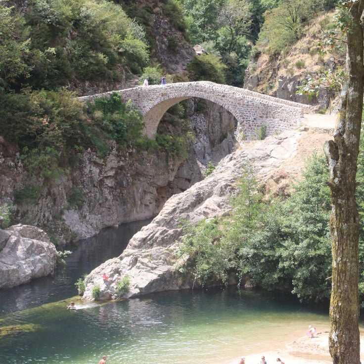
Pont du Diable is a medieval stone bridge spanning the Ardèche River near Thueyts. The arch crosses the river where basalt formations line the banks. Built in the 13th century, the bridge once connected isolated villages on the plateau. From Pont du Diable, you see the black columns of cooled lava rock rising from the riverbed. A footpath leads down to the water and offers views of the structure from below. The bridge still carries foot traffic today and provides access to several routes along the Ardèche.
The Gorges du Chassezac cut through the landscape south of Les Vans, where the river flows between rock walls that rise up to 400 feet (120 meters) in some sections. The valley provides access to several swimming spots along the river, where clear water runs over flat rock slabs. Climbing routes of varying difficulty follow the steep limestone walls, while hiking trails trace the course of the gorge and lead to viewpoints overlooking the wooded slopes and the winding watercourse. The Gorges du Chassezac belong to the less crowded gorges of the Ardèche and combine geological formations with opportunities for outdoor activities.
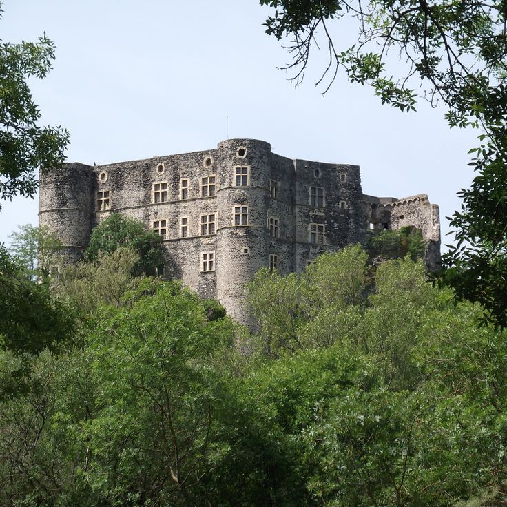
The Château d'Alba la Romaine rises above the remains of the Roman settlement of Alba Helviorum, embodying the layers of Ardèche history. Built in the 11th century, this fortress with its square central tower formed the center of medieval power in a region where stone villages cling to rock faces and history lives in every wall. The facade preserves decorative paintings, while the interior rooms display furnishings and features from various periods. From its walls, views extend across the valley where Romans, feudal lords and farmers have succeeded one another over centuries. This site connects the warm stones of Ardèche with its long human occupation, a testament to the continuity that defines the department between nature and built heritage.
Antraigues-sur-Volane sits at 1,540 feet (470 meters) on the slopes of an extinct volcano. The village has preserved narrow lanes built from basalt stone that wind between houses with dark facades. Along the pathways and on building walls, visitors find over one hundred faces carved into volcanic rock by local sculptors. A Romanesque church stands above the central square. From several vantage points, views extend across the forested valleys of the Ardèche and surrounding mountains. The village was home to singer Jean Ferrat for many years and attracts those interested in walking through historic lanes and discovering the stonework scattered throughout.
The Aven Marzal is a cave system with three levels of underground galleries, accessed by staircases and equipped with lighting. The geological chambers display calcite formations, stalactites and stalagmites that illustrate the slow work of water through limestone. The site also includes a paleontological museum housing fossil finds from the region, offering a concrete view of the geological history of the Ardèche. Visits follow a secured route and last approximately one hour.
Labeaume dates to the 12th century and sits on a limestone cliff above the Beaume River. The lanes are narrow, the houses built from stone, the colors earthy. The village once served as a stop for traders and travelers, and today it draws hikers exploring the Beaume Valley or the Gorges de l'Ardèche. In summer, locals and visitors swim in the river, where the water runs clear and cool. From the village, several marked trails lead into surrounding forests and to the limestone cliffs that rise above the valley. The church of Saint-Pierre-aux-Liens stands on a rocky outcrop and offers views over the valley. The area is part of the Monts d'Ardèche regional nature park.
This natural cave, opened to the public in 1969, sits above the Ardèche Gorge and ranks among the largest accessible cave systems in the region. The Grotte de la Madeleine extends through several underground chambers, where limestone formations such as stalactites, stalagmites and columns appear in various stages of development. The marked route leads through galleries with ceilings reaching up to 131 feet (40 meters), past draperies and speleothems formed by thousands of years of calcium carbonate dissolution and deposition. The guided tour lasts about an hour. At the exit, a wide view opens over the wooded plateau and the limestone cliffs of the surrounding area.
Mont Mézenc rises as the highest peak in the Monts d'Ardèche at 5,751 feet (1,753 meters), marking the border between Ardèche and Haute-Loire. This extinct volcano of phonolite rock shapes the landscape with its characteristic formations and forms the watershed between the Atlantic and Mediterranean. Several hiking trails lead to the summit, including the GR 7, from where a clear day reveals views across the Massif Central to the Alps. The plateau surrounding this mountain contains flora typical of the elevation and lies within a protected natural area that preserves the volcanic past of the region.
The MuséAl in Alba-la-Romaine guides visitors through the Roman past of the region, displaying artifacts recovered from excavations at Alba Helviorum. The permanent collection includes pottery, coins, tools and architectural fragments that document daily life in this Gallo-Roman settlement. The museum complements a visit to the nearby ancient site and offers a tangible understanding of the Roman presence in the Ardèche, away from major tourist routes.
This medieval castle now houses a museum whose rooms on two floors document the region's history. The upper levels offer direct views over the Rhône Valley. The building itself shows construction phases from the 14th through 16th centuries. Inside, archaeological finds, historical documents and objects from daily life of past centuries are displayed. Its riverside location makes the Château de Tournon a recognizable landmark in this part of Ardèche.
The Muséum de l'Ardèche displays a collection of fossils discovered in the region across 2,150 square feet (200 square meters), including marine and terrestrial specimens from various geological periods. The exhibition documents the history of this landscape, which was covered by seas millions of years ago before tectonic forces shaped it. Visitors see fossilized shells, ammonites and other evidence of past life forms discovered in the limestone layers of the Ardèche. The museum is located in Balazuc, one of the characteristic stone villages on the edge of the Gorges de l'Ardèche, where the geological past remains readable in the surrounding rock formations.
This cave descends through a series of underground galleries on multiple levels, displaying limestone formations built over thousands of years. The Aven d'Orgnac alternates vast chambers with stalactites, stalagmites and hanging formations that give scale and time a physical presence. Visitors follow a developed path that winds down and loops through several rooms, some reaching extraordinary heights of around 160 feet (50 meters). A prehistory museum on the site above complements the visit, presenting findings from settlements and caves across the region. This location ranks among the significant natural spaces of the Ardèche and offers insight into the work of water beneath the surface.
This museum in Cruas dedicates 2,700 square feet (250 m²) to the history and evolution of sports. The collection displays historic and contemporary sporting equipment across various disciplines and includes interactive simulation areas where visitors can engage directly. The exhibition combines documentary elements with hands-on experiences, making the development of athletic practices and technologies accessible. Located in Cruas, a town in the southern Ardèche, the museum complements the regional offering between nature exploration and cultural heritage by focusing on movement and physical activity.
Vals-les-Bains is a spa town with a long tradition of hydrotherapy. The naturally carbonated mineral springs have been used for therapeutic purposes since the 17th century. The thermal center offers various treatments based on the mineral properties of the local springs. The town sits in a narrow valley and combines bathing culture with the Ardèche landscape. Several springs are accessible to the public, allowing visitors to taste the water directly. The historical development as a spa town has shaped the architecture and character of the place.
This mountain trail climbs through wooded terrain to a viewpoint above Andance, offering views across the Rhône Valley and the Vivarais hills. The ascent follows mixed forest paths and rocky sections that bridge the elevation gain between the village and the summit. At the top, the landscape opens to reveal the river plain, the opposite slopes and the layout of the middle Rhône corridor. The three crosses mark the highest point of the hike and have served as landmarks for walkers and pilgrims for generations. The descent can follow the same route or take alternative paths through vineyards and terraced cultivation back to the village.
The Eyrieux Valley cuts through the Ardèche over 28 miles (45 kilometers), following a former railway line now converted into a cycling and walking path. The route connects La Voulte-sur-Rhône to Le Cheylard, offering a paved trail through forests, alongside the river and past villages. Gradients remain gentle, and old train stations have been repurposed as rest stops. This corner of the Ardèche reveals a quieter side of the region, less dramatic than the Gorges but equally tangible in its history and landscape.
This natural limestone arch marks the gateway to the Gorges de l'Ardèche and stands as one of the region's most recognized geological formations. The Ardèche River has carved through the rock over thousands of years, creating a span that reaches 177 feet (54 meters) in height and 197 feet (60 meters) in width. The Pont d'Arc is visible from both the riverbanks and the water itself, serving as the starting point for canoe trips through the gorges. The surrounding area offers hiking trails and swimming spots where visitors can grasp the scale of this formation.
This cave was discovered in 1994 and preserves over a thousand paintings on its walls dating back 36,000 years. Bison, lions, bears – images from a vanished world that still impress with their vitality. The Grotte Chauvet contains some of the oldest known cave art created by humans and documents the artistic skill of our ancestors. Access to the original cave is restricted to protect the artwork, but a faithful replica, the Grotte Chauvet 2, allows visitors to experience the representations in their original arrangement. The replica was created with scientific precision and conveys an authentic impression of Ice Age art.
This museum in Saint-Remèze traces the history and cultivation of lavender, a plant grown in this region for generations. Visitors encounter historic distillation equipment, farming tools and explanations of traditional methods for producing essential oils. The exhibits detail lavender's economic role in the area and clarify the differences between lavender varieties and their applications. An outdoor section with flowering lavender fields complements the indoor displays. Located near the Gorges de l'Ardèche, the museum offers insight into an agricultural heritage that has shaped southern France.
The Cité du Chocolat Valrhona walks visitors through the complete journey from cacao bean to finished product. This center in Tain-l'Hermitage presents manufacturing processes, ingredient origins, and flavor profiles through interactive exhibits. Tasting stations offer various chocolate types with different cacao percentages and regional sources. Workshops provide hands-on experience with techniques like tempering and molding. The museum combines technical knowledge with sensory exploration, making the complexity of chocolate production accessible to all ages.
The Cité de la Préhistoire provides direct access to the prehistoric past of the Ardèche region. This museum displays archaeological finds spanning three millennia, from the Paleolithic through the Bronze Age. Exhibition rooms explain the development of human societies through tools, pottery and skeletal remains recovered from local excavations. Interactive stations demonstrate techniques such as fire-making and stone-working. The research center collaborates with regional archaeological sites and regularly updates its collections. A visit takes about two hours and pairs well with the nearby Aven d'Orgnac, one of the largest caves in southern France.
The Gorges de l'Ardèche form a limestone canyon carved by the Ardèche River over 19 miles (30 kilometers) between Vallon-Pont-d'Arc and Saint-Martin-d'Ardèche, with cliffs reaching up to nearly 1,000 feet (300 meters) in height. The gorge features numerous viewpoints along a winding scenic road that follows the river's course. Visitors can explore the gorge on foot, by canoe, or by bicycle, with the river offering paddling routes during summer months and marked hiking trails running through the limestone formations.
Mont Gerbier de Jonc is a 5089-foot (1551-meter) volcanic peak in the southern Massif Central, rising from the plateau with its distinctive phonolite dome. Three springs at its base mark the source of the Loire River, which begins its 620-mile (1000-kilometer) journey to the Atlantic from this point. The summit trail takes about 45 minutes through moorland and offers views across the volcanic ranges of Ardèche. The mountain's steep conical shape comes from phonolite, an uncommon volcanic rock that formed during ancient eruptions. A small museum near the parking area explains the site's hydrological significance and the mountain's geological history.
This zoological park covers 80 hectares (198 acres) and houses around 1,200 animals representing 128 different species. Safari de Peaugres offers two ways to explore: a walking trail through themed areas featuring primates, predators and birds, and a driving circuit several miles long where visitors observe giraffes, lions, bears and other large animals from their own vehicles. Located on the edge of Ardèche, the park combines conservation efforts with practical education programs. Families will find playgrounds, picnic areas and several daily feeding sessions with commentary at various animal exhibits.
The Bois de Païolive stretches across 6 square miles (16 square kilometers) of white oak forest and limestone formations carved by erosion into natural labyrinths. Wind and water have shaped the rocks into forms resembling animals, buildings, or abstract sculptures. Marked trails guide visitors through this forested landscape where light and shadow shift between twisted trees and gray stone blocks. The terrain requires sturdy footwear and a sense of direction, as paths sometimes fork between the rocks. The combination of Mediterranean vegetation and geological formations makes this forest a place where nature and time work together in visible ways.
Between Saint-Jean-de-Muzols and Lamastre, this historic steam train works its way through the Doux Valley. The Train du Vivarais covers 21 miles (33 kilometers) on a narrow gauge line built in the early 1900s, crossing viaducts and tunneling through rock as it connects two villages in the Ardèche backcountry. The locomotive burns coal and emits black smoke and rhythmic whistles that echo off the valley walls. Passengers ride in vintage carriages through forested slopes and past riverbanks, experiencing rail travel as it was more than a century ago. The journey takes about two hours each way and offers a practical look at regional history and terrain from an angle you cannot get by car.
This waterfall drops 200 feet (60 meters) over a wall of basalt columns formed by ancient volcanic activity. The Ray-Pic is reached by a short forest trail and marks a dramatic point where the Bourges River tumbles over solidified lava. The geometric columns and the roar of the water create an unusual scene in this remote corner of the Ardèche. A visit takes about an hour, longer if you explore the surrounding trails.
The Grotte de la Cocalière extends for about three fifths of a mile (1 kilometer) beneath the surface, displaying a sequence of limestone formations shaped over thousands of years. The tour moves through several chambers filled with stalactites, stalagmites and flowing stone curtains, alongside an underground river. Sections of the network contain prehistoric traces indicating early human presence. Access is by guided tour only, lasting around an hour through lit passages. The circuit concludes with a short ride on a small train covering the final stretch back to the exit. Interior climate remains steady year round at approximately 57 degrees Fahrenheit (14 degrees Celsius).
This rail bike operates on a former railway line along the Doux Gorges, offering four different routes ranging from 5 to 12.4 miles (8 to 20 kilometers) in length. The track runs through the wooded river valley, combining physical activity with access to the natural landscape. The ride follows original rails that once served freight transport, providing an unconventional way to experience the region's terrain. The Vélorail des Gorges du Doux connects the history of local rail infrastructure with a practical approach to exploring the Doux Valley.
The ruins of Château de Crussol stand on a rocky promontory 1,300 feet (400 m) above the Rhône Valley, documenting the strategic vision of medieval builders. Built in the 12th century, this fortress once controlled trade routes between the Rhône corridor and the Massif Central. Today the remaining walls, towers and vaulted chambers testify to the military engineering of that era. The climb through Mediterranean scrubland leads to remnants of watchtowers, living quarters and cisterns. From the ruins, views extend across the Rhône Valley, the Ardèche plateaus and on clear days toward Mont Blanc. The site demonstrates how natural topography and human construction merged to create one of the region's most important fortifications.
Balazuc is a medieval village dating from the 11th century, built on a rocky outcrop above the Ardèche River. The fortified settlement preserves its keep, castle and narrow cobbled lanes that wind between stone houses. The elevated position provided protection for centuries and now offers wide views over the river valley. Like many sites in the region, Balazuc shows how people adapted to the rocky terrain, integrating their buildings into the cliffs. The village is one of the historic settlements that define the cultural heritage of the Ardèche, where nature and architecture have intertwined since the Middle Ages.
The Balmes de Montbrun are a network of dwellings carved into volcanic rock, documenting human occupation since the Middle Ages. These cave homes, cut into the cliff face of the Coiron plateau, reflect centuries of adaptation to the Ardèche landscape. The site includes multiple levels of chambers hewn directly from porous basalt, which once served as permanent residences. The location offers insight into traditional building techniques and how residents utilized the natural properties of volcanic stone. The Balmes sit within a region known for its geological diversity, fitting into the mosaic of natural heritage and historic settlements that defines the Ardèche.
Vogüé clings to the side of a steep limestone outcrop, a medieval village where stone houses press against the walls of an 11th-century château. Narrow lanes wind between dwellings linked by vaulted passageways, connecting different levels of the village that was ruled for centuries by the Lords of Vogüé. The château, rebuilt several times over, dominates the scene from its rocky perch while stone terraces open toward the water at the riverbank. Located at the foot of the Ardèche, the village offers direct access to the river gorges downstream and the wooded limestone plateaus above.
This cave extends across 35 miles (57 kilometers) of underground passages, linking limestone formations with geological history. Guided tours reveal calcite deposits, natural pools and concretions that formed over millennia. The accessible section offers insight into the processes that shaped the Ardèche plateau. Visitors follow marked paths through lit chambers, where guides explain the formation of stalactites and stalagmites and the role of water in carving the limestone.
The Château d'Aubenas sits above the town and provides insight into the region's medieval architecture. Built in the 12th century, this fortress underwent modifications over the centuries and now displays elements from different periods. Visitors explore the guard room, decorated chambers and climb the tower for a panorama across the Ardèche valley. The castle serves as a cultural center with rotating exhibitions and documents the history of this area between the Cévennes and the Rhône valley.
These limestone gorges follow the Beaume River for 20 miles (32 kilometers), connecting the village of Joyeuse with the Ardèche River near Ruoms. The D24 road runs along the watercourse between steep rock walls rising up to 490 feet (150 meters). Several hiking trails start from parking areas along the route, providing access to the riverbank, gravel beaches and viewpoints above the gorge. The Beaume flows year-round, including during summer, and offers natural pools suitable for swimming among the rocks. In winter, the road typically remains open, though the water runs higher.
Pont du Diable is a medieval stone bridge spanning the Ardèche River near Thueyts. The arch crosses the river where basalt formations line the banks. Built in the 13th century, the bridge once connected isolated villages on the plateau. From Pont du Diable, you see the black columns of cooled lava rock rising from the riverbed. A footpath leads down to the water and offers views of the structure from below. The bridge still carries foot traffic today and provides access to several routes along the Ardèche.
The Gorges du Chassezac cut through the landscape south of Les Vans, where the river flows between rock walls that rise up to 400 feet (120 meters) in some sections. The valley provides access to several swimming spots along the river, where clear water runs over flat rock slabs. Climbing routes of varying difficulty follow the steep limestone walls, while hiking trails trace the course of the gorge and lead to viewpoints overlooking the wooded slopes and the winding watercourse. The Gorges du Chassezac belong to the less crowded gorges of the Ardèche and combine geological formations with opportunities for outdoor activities.
The Château d'Alba la Romaine rises above the remains of the Roman settlement of Alba Helviorum, embodying the layers of Ardèche history. Built in the 11th century, this fortress with its square central tower formed the center of medieval power in a region where stone villages cling to rock faces and history lives in every wall. The facade preserves decorative paintings, while the interior rooms display furnishings and features from various periods. From its walls, views extend across the valley where Romans, feudal lords and farmers have succeeded one another over centuries. This site connects the warm stones of Ardèche with its long human occupation, a testament to the continuity that defines the department between nature and built heritage.
Antraigues-sur-Volane sits at 1,540 feet (470 meters) on the slopes of an extinct volcano. The village has preserved narrow lanes built from basalt stone that wind between houses with dark facades. Along the pathways and on building walls, visitors find over one hundred faces carved into volcanic rock by local sculptors. A Romanesque church stands above the central square. From several vantage points, views extend across the forested valleys of the Ardèche and surrounding mountains. The village was home to singer Jean Ferrat for many years and attracts those interested in walking through historic lanes and discovering the stonework scattered throughout.
The Aven Marzal is a cave system with three levels of underground galleries, accessed by staircases and equipped with lighting. The geological chambers display calcite formations, stalactites and stalagmites that illustrate the slow work of water through limestone. The site also includes a paleontological museum housing fossil finds from the region, offering a concrete view of the geological history of the Ardèche. Visits follow a secured route and last approximately one hour.
Labeaume dates to the 12th century and sits on a limestone cliff above the Beaume River. The lanes are narrow, the houses built from stone, the colors earthy. The village once served as a stop for traders and travelers, and today it draws hikers exploring the Beaume Valley or the Gorges de l'Ardèche. In summer, locals and visitors swim in the river, where the water runs clear and cool. From the village, several marked trails lead into surrounding forests and to the limestone cliffs that rise above the valley. The church of Saint-Pierre-aux-Liens stands on a rocky outcrop and offers views over the valley. The area is part of the Monts d'Ardèche regional nature park.
This natural cave, opened to the public in 1969, sits above the Ardèche Gorge and ranks among the largest accessible cave systems in the region. The Grotte de la Madeleine extends through several underground chambers, where limestone formations such as stalactites, stalagmites and columns appear in various stages of development. The marked route leads through galleries with ceilings reaching up to 131 feet (40 meters), past draperies and speleothems formed by thousands of years of calcium carbonate dissolution and deposition. The guided tour lasts about an hour. At the exit, a wide view opens over the wooded plateau and the limestone cliffs of the surrounding area.
Mont Mézenc rises as the highest peak in the Monts d'Ardèche at 5,751 feet (1,753 meters), marking the border between Ardèche and Haute-Loire. This extinct volcano of phonolite rock shapes the landscape with its characteristic formations and forms the watershed between the Atlantic and Mediterranean. Several hiking trails lead to the summit, including the GR 7, from where a clear day reveals views across the Massif Central to the Alps. The plateau surrounding this mountain contains flora typical of the elevation and lies within a protected natural area that preserves the volcanic past of the region.
The MuséAl in Alba-la-Romaine guides visitors through the Roman past of the region, displaying artifacts recovered from excavations at Alba Helviorum. The permanent collection includes pottery, coins, tools and architectural fragments that document daily life in this Gallo-Roman settlement. The museum complements a visit to the nearby ancient site and offers a tangible understanding of the Roman presence in the Ardèche, away from major tourist routes.
This medieval castle now houses a museum whose rooms on two floors document the region's history. The upper levels offer direct views over the Rhône Valley. The building itself shows construction phases from the 14th through 16th centuries. Inside, archaeological finds, historical documents and objects from daily life of past centuries are displayed. Its riverside location makes the Château de Tournon a recognizable landmark in this part of Ardèche.
The Muséum de l'Ardèche displays a collection of fossils discovered in the region across 2,150 square feet (200 square meters), including marine and terrestrial specimens from various geological periods. The exhibition documents the history of this landscape, which was covered by seas millions of years ago before tectonic forces shaped it. Visitors see fossilized shells, ammonites and other evidence of past life forms discovered in the limestone layers of the Ardèche. The museum is located in Balazuc, one of the characteristic stone villages on the edge of the Gorges de l'Ardèche, where the geological past remains readable in the surrounding rock formations.
This cave descends through a series of underground galleries on multiple levels, displaying limestone formations built over thousands of years. The Aven d'Orgnac alternates vast chambers with stalactites, stalagmites and hanging formations that give scale and time a physical presence. Visitors follow a developed path that winds down and loops through several rooms, some reaching extraordinary heights of around 160 feet (50 meters). A prehistory museum on the site above complements the visit, presenting findings from settlements and caves across the region. This location ranks among the significant natural spaces of the Ardèche and offers insight into the work of water beneath the surface.
This museum in Cruas dedicates 2,700 square feet (250 m²) to the history and evolution of sports. The collection displays historic and contemporary sporting equipment across various disciplines and includes interactive simulation areas where visitors can engage directly. The exhibition combines documentary elements with hands-on experiences, making the development of athletic practices and technologies accessible. Located in Cruas, a town in the southern Ardèche, the museum complements the regional offering between nature exploration and cultural heritage by focusing on movement and physical activity.
Vals-les-Bains is a spa town with a long tradition of hydrotherapy. The naturally carbonated mineral springs have been used for therapeutic purposes since the 17th century. The thermal center offers various treatments based on the mineral properties of the local springs. The town sits in a narrow valley and combines bathing culture with the Ardèche landscape. Several springs are accessible to the public, allowing visitors to taste the water directly. The historical development as a spa town has shaped the architecture and character of the place.
This mountain trail climbs through wooded terrain to a viewpoint above Andance, offering views across the Rhône Valley and the Vivarais hills. The ascent follows mixed forest paths and rocky sections that bridge the elevation gain between the village and the summit. At the top, the landscape opens to reveal the river plain, the opposite slopes and the layout of the middle Rhône corridor. The three crosses mark the highest point of the hike and have served as landmarks for walkers and pilgrims for generations. The descent can follow the same route or take alternative paths through vineyards and terraced cultivation back to the village.
The Eyrieux Valley cuts through the Ardèche over 28 miles (45 kilometers), following a former railway line now converted into a cycling and walking path. The route connects La Voulte-sur-Rhône to Le Cheylard, offering a paved trail through forests, alongside the river and past villages. Gradients remain gentle, and old train stations have been repurposed as rest stops. This corner of the Ardèche reveals a quieter side of the region, less dramatic than the Gorges but equally tangible in its history and landscape.