Chest opened
+${chestReward.xp} XP
Explorer
NOUVEAU ×${chestReward.collectible.quantity}
tapez pour fermer
Chest locked

Open chests in the app

Around Us is built for your phone — chests unlock when you walk, explore and capture nearby places.

Enable Location

We need your location to show you interesting places around you

Discover nearby places

Find interesting locations and hidden gems around you

Precise directions

Get accurate directions and distances to places

Your location is never shared with other users. It's only used when you tap the location button.

Menominee River

Log in to your account

Start exploring — it's free

Trusted by 72,886 travelers worldwide

Continue with Google
Continue with Apple
or

We will send you a code to connect

By continuing, you accept our Terms and Conditions and our Privacy Policy

Check your inbox

We've sent a pincode in your inbox. Please enter the code below.

Menominee River
Discussion Reviews 1 Photos
11.8k Popularity

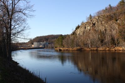
Menominee River, Natural border river between Michigan and Wisconsin, United States

The Menominee River is a border river between Michigan and Wisconsin that flows for about 116 miles through the northwestern region. It receives water from several tributaries and forms a natural water boundary between the two states.

In the late 1800s the river was a key transportation route for logging timber and moving iron ore to industrial sites. This role as a transport corridor shaped the economic growth of the surrounding region.

The name comes from the Ojibwe language and refers to wild rice that once grew along the banks and fed the people living here. The river landscape today still reflects this deep connection to the natural world.

The river has several access points for anglers looking to fish for pike, bass, and other species. Multiple bridges cross it at different locations, making it easy to move between Michigan and Wisconsin.

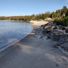
The river forms a series of deep reservoirs with limited shoreline development that protects water quality. This natural structure preserves habitats for fish and wildlife, keeping the banks a true wild refuge.

The community of curious travelers

AroundUs brings together thousands of curated places, local tips, and hidden gems, enriched daily by 60,000 contributors worldwide.

Start exploring
Location
Location
Location
Location
Location
GPS coordinates
45.09471,-87.59122
Latest update
December 7, 2025 20:49
Around this place
DeYoung Family Zoo
United States of America

DeYoung Family Zoo

24.1 km
Green Island Light
United States of America

Green Island Light

8.8 km
Interstate Bridge
United States of America

Interstate Bridge

2.9 km
Peshtigo Fire Museum
United States of America

Peshtigo Fire Museum

13.5 km
Sherwood Point Light
United States of America

Sherwood Point Light

25.6 km
Eagle Bluff Light
United States of America

Eagle Bluff Light

29 km
Alexander Noble House
United States of America

Alexander Noble House

27.3 km
Peshtigo Fire Cemetery
United States of America

Peshtigo Fire Cemetery

13.5 km
Bayshore Blufflands State Natural Area
United States of America

Bayshore Blufflands State Natural Area

23.8 km
Riverside Site
United States of America

Riverside Site

5.5 km
Chambers Island Light
United States of America

Chambers Island Light

21.5 km
Church of the Atonement
United States of America

Church of the Atonement

27.1 km
Cupola House
United States of America

Cupola House

24.9 km
Peshtigo Reef Light
United States of America

Peshtigo Reef Light

15.4 km
St. John the Baptist Catholic Church
United States of America

St. John the Baptist Catholic Church

2.3 km
F.J. Lauerman House
United States of America

F.J. Lauerman House

3.8 km
Dunlap Square Building
United States of America

Dunlap Square Building

3.2 km
Vorous General Store
United States of America

Vorous General Store

27.3 km
First Street Historic District
United States of America

First Street Historic District

1.5 km
Bijou Theatre
United States of America

Bijou Theatre

3.1 km
Freeman and Jesse Thorp House and Cottages
United States of America

Freeman and Jesse Thorp House and Cottages

27.5 km
Independent Order of Odd Fellows-Lodge No. 189 Building
United States of America

Independent Order of Odd Fellows-Lodge No. 189 Building

2.4 km
Egg Harbor Fun Park
United States of America

Egg Harbor Fun Park

25 km
Potawatomi State Park Observation Tower
United States of America

Potawatomi State Park Observation Tower

27.5 km
Menominee Pier Light
United States of America

Menominee Pier Light

501 m
Egg Harbor Beach
United States of America

Egg Harbor Beach

24.7 km
Menominee County Courthouse
United States of America

Menominee County Courthouse

2.2 km
Menekaunee, Wisconsin
United States of America

Menekaunee, Wisconsin

836 m
Show the full map
Reviews
Share your experience

No review yet

Discussions
Start a discussion...

No discussion yet

« Menominee River - Natural border river between Michigan and Wisconsin, United States » is provided by Around Us (aroundus.com). Images and texts are derived from Wikimedia project under a Creative Commons license. You are allowed to copy, distribute, and modify copies of this page, under the conditions set by the license, as long as this note is clearly visible.

Discover hidden gems everywhere you go!

From secret cafés to breathtaking viewpoints, skip the crowded tourist spots and find places that match your style. Our app makes it easy with voice search, smart filtering, route optimization, and insider tips from travelers worldwide. Download now for the complete mobile experience.

Around Us App Screenshot

A unique approach to discovering new places

Le Figaro

All the places worth exploring

France Info

A tailor-made excursion in just a few clicks

20 Minutes

Around Us
Travel Guide & Maps
Download

Send to your phone

QR Code
1

Open the camera app on your mobile.

2

Point at the QR code with your camera. A notification will appear.

3

Tap the notification to open the link.