Enable Location

We need your location to show you interesting places around you

Discover nearby places

Find interesting locations and hidden gems around you

Precise directions

Get accurate directions and distances to places

Your location is never shared with other users. It's only used when you tap the location button.

Goat Canyon Trestle

Log in to your account

Start exploring — it's free

Trusted by 62,033 travelers worldwide

Continue with Google
Continue with Apple
or

We will send you a code to connect

By continuing, you accept our Terms and Conditions and our Privacy Policy

Check your inbox

We've sent a pincode in your inbox. Please enter the code below.

Goat Canyon Trestle

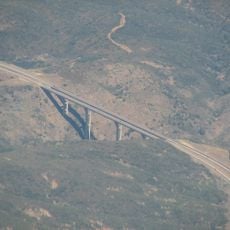
Goat Canyon Trestle, Railway bridge in Anza-Borrego Desert State Park, United States

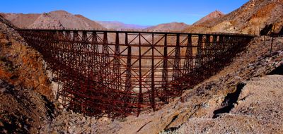
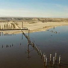
Goat Canyon Trestle is a railway bridge in San Diego County, United States, spanning a desert gorge while following a gentle arc. The wooden piers rise about 200 feet (61 meters) above the ground, while the platform rests on multiple rows of vertical supports leaning against the rock walls.

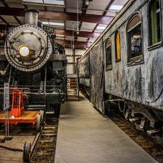
The bridge arose in 1933 after a tunnel collapse on the line between San Diego and Arizona. It remained in operation until 1976 and was then abandoned when freight traffic ended and the line closed.

Redwood timber from northern California forms the framework of this bridge, chosen because it warps less than steel in extreme heat and cold. The nail-free construction uses interlocking joints and bolts, a method from the early 20th century that remains visible in several desert rail lines today.

Access is via a roughly 6-mile trail through desert terrain, requiring experience with rocky paths and several liters of water per person. The best time is between October and April when temperatures stay below 86 degrees Fahrenheit (30 degrees Celsius) and the route becomes less risky.

This bridge is considered the largest curved wooden trestle in the world, following a 14-degree arc across its full length. The curve was designed to distribute wind forces and reduce the risk of gusts tearing the structure from its anchors.

The community of curious travelers

AroundUs brings together thousands of curated places, local tips, and hidden gems, enriched daily by 60,000 contributors worldwide.

Start exploring
Location
Inception
1933
Made from material
Sequoioideae
GPS coordinates
32.72917,-116.18333
Latest update
December 17, 2025 09:48
Around this place
Anza-Borrego Desert State Park
United States of America

Anza-Borrego Desert State Park

62.3 km
Cuyamaca Rancho State Park
United States of America

Cuyamaca Rancho State Park

43.3 km
Cuyamaca Peak
United States of America

Cuyamaca Peak

46.4 km
Sonny Bono Salton Sea National Wildlife Refuge
United States of America

Sonny Bono Salton Sea National Wildlife Refuge

63 km
Desert View Tower
United States of America

Desert View Tower

11.1 km
Mount Laguna Observatory
United States of America

Mount Laguna Observatory

26.1 km
Mud Caves
United States of America

Mud Caves

21.8 km
Otay Mountain
United States of America

Otay Mountain

63.8 km
Pine Valley Creek Bridge
United States of America

Pine Valley Creek Bridge

36.8 km
El Vallecito
Mexico

El Vallecito

24.4 km
Sawtooth Mountains Wilderness
United States of America

Sawtooth Mountains Wilderness

25.1 km
Santa Ysabel Asistencia
United States of America

Santa Ysabel Asistencia

64.3 km
El Capitan Reservoir
United States of America

El Capitan Reservoir

61.1 km
El Cajon Mountain
United States of America

El Cajon Mountain

63.1 km
Fish Creek Mountains Wilderness
United States of America

Fish Creek Mountains Wilderness

31.6 km
Viejas Mountain
United States of America

Viejas Mountain

52.9 km
Barrett Dam
United States of America

Barrett Dam

46 km
Tecate Peak
United States of America

Tecate Peak

50.2 km
Loveland Dam
United States of America

Loveland Dam

57.5 km
La Posta Astro-Geophysical Observatory
United States of America

La Posta Astro-Geophysical Observatory

24.4 km
Lyons Peak
United States of America

Lyons Peak

54.4 km
McGinty Mountain
United States of America

McGinty Mountain

63.5 km
Morena Reservoir
United States of America

Morena Reservoir

33.1 km
Pacific Southwest Railway Museum Association
United States of America

Pacific Southwest Railway Museum Association

30 km
"Camp Alaska" Site Museum
Mexico

"Camp Alaska" Site Museum

23.2 km
Estación de Inspección de los Estados Unidos-Tecate
United States of America

Estación de Inspección de los Estados Unidos-Tecate

44.9 km
Pacific Crest Trail Southern Terminus
United States of America

Pacific Crest Trail Southern Terminus

30.8 km
Sea View Beach
United States of America

Sea View Beach

62.1 km
Show the full map
« Goat Canyon Trestle - Railway bridge in Anza-Borrego Desert State Park, United States » is provided by Around Us (aroundus.com). Images and texts are derived from Wikimedia project under a Creative Commons license. You are allowed to copy, distribute, and modify copies of this page, under the conditions set by the license, as long as this note is clearly visible.

Discover hidden gems everywhere you go!

From secret cafés to breathtaking viewpoints, skip the crowded tourist spots and find places that match your style. Our app makes it easy with voice search, smart filtering, route optimization, and insider tips from travelers worldwide. Download now for the complete mobile experience.

Around Us App Screenshot

A unique approach to discovering new places

Le Figaro

All the places worth exploring

France Info

A tailor-made excursion in just a few clicks

20 Minutes

Around Us
Travel Guide & Maps
Download

Send to your phone

QR Code
1

Open the camera app on your mobile.

2

Point at the QR code with your camera. A notification will appear.

3

Tap the notification to open the link.