Enable Location

We need your location to show you interesting places around you

Discover nearby places

Find interesting locations and hidden gems around you

Precise directions

Get accurate directions and distances to places

Your location is never shared with other users. It's only used when you tap the location button.

Pine Valley Creek Bridge

Log in to your account

Start exploring — it's free

Trusted by 62,031 travelers worldwide

Continue with Google
Continue with Apple
or

We will send you a code to connect

By continuing, you accept our Terms and Conditions and our Privacy Policy

Check your inbox

We've sent a pincode in your inbox. Please enter the code below.

Pine Valley Creek Bridge

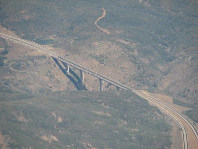
Pine Valley Creek Bridge, Highway bridge in Pine Valley, California.

The Pine Valley Creek Bridge is a highway bridge in California that crosses a deep canyon using concrete beam construction. The main span extends roughly 450 feet, while the overall height of the structure reaches approximately 440 feet.

The bridge opened in 1974 as the first United States structure built using the cast-in-place segmental balanced cantilever method for concrete construction. This innovative technique marked a turning point in bridge engineering and influenced future projects.

The bridge honors transportation engineer Nello Irwin Greer through its official name, a tribute granted by the California State Senate. This naming reflects the region's recognition of the people who shaped modern infrastructure.

The bridge carries Interstate 8 traffic and sits about 60 miles east of San Diego in California's desert region. It is a major traffic route, so travelers should expect regular vehicle flow when crossing.

Engineer Man-Chung Tang designed this structure entirely from scratch, developing revolutionary construction techniques in the process. These innovations quickly spread and shaped bridge projects throughout North America for decades to come.

The community of curious travelers

AroundUs brings together thousands of curated places, local tips, and hidden gems, enriched daily by 60,000 contributors worldwide.

Start exploring
Location
Inception
1974
GPS coordinates
32.82310,-116.56000
Latest update
December 10, 2025 20:02
Around this place
Goat Canyon Trestle
United States of America

Goat Canyon Trestle

36.8 km
Cuyamaca Rancho State Park
United States of America

Cuyamaca Rancho State Park

13.1 km
Blackjack Hall of Fame
United States of America

Blackjack Hall of Fame

32.2 km
Barona Casino
United States of America

Barona Casino

32.1 km
Viejas Casino
United States of America

Viejas Casino

13.7 km
Cuyamaca Peak
United States of America

Cuyamaca Peak

14.4 km
San Vicente Reservoir
United States of America

San Vicente Reservoir

35.5 km
Mount Laguna Observatory
United States of America

Mount Laguna Observatory

12.5 km
Mud Caves
United States of America

Mud Caves

36.5 km
Otay Mountain
United States of America

Otay Mountain

36.9 km
Sawtooth Mountains Wilderness
United States of America

Sawtooth Mountains Wilderness

21.2 km
Santa Ysabel Asistencia
United States of America

Santa Ysabel Asistencia

35.9 km
El Capitan Reservoir
United States of America

El Capitan Reservoir

24.3 km
El Cajon Mountain
United States of America

El Cajon Mountain

26.4 km
San Vicente Dam
United States of America

San Vicente Dam

35.5 km
Viejas Mountain
United States of America

Viejas Mountain

16.1 km
Barrett Dam
United States of America

Barrett Dam

19.1 km
Tecate Peak
United States of America

Tecate Peak

29.7 km
Loveland Dam
United States of America

Loveland Dam

22.4 km
La Posta Astro-Geophysical Observatory
United States of America

La Posta Astro-Geophysical Observatory

19.9 km
Lyons Peak
United States of America

Lyons Peak

23.3 km
McGinty Mountain
United States of America

McGinty Mountain

29.2 km
Morena Reservoir
United States of America

Morena Reservoir

15.4 km
Pacific Southwest Railway Museum Association
United States of America

Pacific Southwest Railway Museum Association

24.7 km
Estación de Inspección de los Estados Unidos-Tecate
United States of America

Estación de Inspección de los Estados Unidos-Tecate

28.1 km
Jardín Ahorrador de Agua en el Cuyamaca College
United States of America

Jardín Ahorrador de Agua en el Cuyamaca College

36.6 km
San Vicente Golf Club
United States of America

San Vicente Golf Club

30.5 km
Museum
United States of America

Museum

36.7 km
Show the full map
« Pine Valley Creek Bridge - Highway bridge in Pine Valley, California » is provided by Around Us (aroundus.com). Images and texts are derived from Wikimedia project under a Creative Commons license. You are allowed to copy, distribute, and modify copies of this page, under the conditions set by the license, as long as this note is clearly visible.

Discover hidden gems everywhere you go!

From secret cafés to breathtaking viewpoints, skip the crowded tourist spots and find places that match your style. Our app makes it easy with voice search, smart filtering, route optimization, and insider tips from travelers worldwide. Download now for the complete mobile experience.

Around Us App Screenshot

A unique approach to discovering new places

Le Figaro

All the places worth exploring

France Info

A tailor-made excursion in just a few clicks

20 Minutes

Around Us
Travel Guide & Maps
Download

Send to your phone

QR Code
1

Open the camera app on your mobile.

2

Point at the QR code with your camera. A notification will appear.

3

Tap the notification to open the link.