
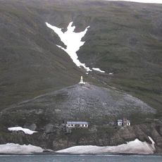
Поселок «Пинакуль», historic site in Chukotka Autonomous Okrug, Russia
Location: Chukotka Autonomous Okrug
GPS coordinates: 65.62712,-170.84461
Latest update: May 28, 2025 16:14
Naukan
67.6 km
Whale Bone Alley
134.9 km
Beringia National Park
181.7 km
Monument to Semyon Dezhnev
67.7 km
Trail Creek Caves
340.5 km
Pilgrim Hot Springs
281.1 km
Cape Nome Mining District Discovery Sites
282.5 km
Council City and Solomon River Railroad
323.7 km
Old St. Joseph's Catholic Church
284.2 km
Nome River
282.4 km
Snake River
274.8 km
Chamisso Wilderness
414.6 km
Wales Site
126.8 km
Cape Vankarem
329.6 km
Kougarok River
283.7 km
Squirrel River
469.6 km
Kuzitrin River
300.1 km
Swanberg Dredge
286.4 km
Solomon Roadhouse
322.8 km
Niukluk River
331.1 km
Iyatayet Site
458.6 km
Kugruk River
377.1 km
Shishmaref Inlet
235.8 km
Noxapaga River
311.3 km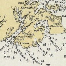
Slavyanka Cove
183 km
Историко-культурный комплекс Пловер
183.8 km
Kugururok River
509.6 km
Памятный знак в честь 250-летия Первой Камчатской экспедиции (Провидения)
175.7 kmReviews
Visited this place? Tap the stars to rate it and share your experience / photos with the community! Try now! You can cancel it anytime.
Discover hidden gems everywhere you go!
From secret cafés to breathtaking viewpoints, skip the crowded tourist spots and find places that match your style. Our app makes it easy with voice search, smart filtering, route optimization, and insider tips from travelers worldwide. Download now for the complete mobile experience.

A unique approach to discovering new places❞
— Le Figaro
All the places worth exploring❞
— France Info
A tailor-made excursion in just a few clicks❞
— 20 Minutes