Chest opened
+${chestReward.xp} XP
Explorer
NOUVEAU ×${chestReward.collectible.quantity}
tapez pour fermer
Chest locked

Open chests in the app

Around Us is built for your phone — chests unlock when you walk, explore and capture nearby places.

Enable Location

We need your location to show you interesting places around you

Discover nearby places

Find interesting locations and hidden gems around you

Precise directions

Get accurate directions and distances to places

Your location is never shared with other users. It's only used when you tap the location button.

Log in to your account

Start exploring — it's free

Trusted by 73,026 travelers worldwide

Continue with Google
Continue with Apple
or

We will send you a code to connect

By continuing, you accept our Terms and Conditions and our Privacy Policy

Check your inbox

We've sent a pincode in your inbox. Please enter the code below.

Manitou Park Recreation Area, Colorado
Discussion Reviews Photo
1.2k Popularity

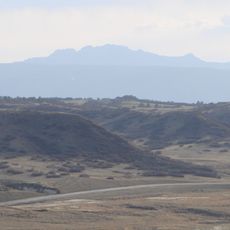
Manitou Park Recreation Area, Colorado, Recreational park in Pike National Forest, Colorado

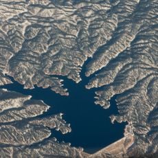
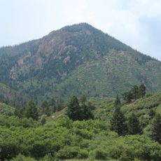
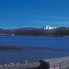
Manitou Park Recreation Area is a recreation site in Pike National Forest featuring a 5-acre lake, grassy meadows, and ponderosa pine trees arranged across multiple camping and day-use zones. The location sits at an elevation of 7,700 feet, creating cooler conditions during summer months.

The earthen dam creating Manitou Lake was built in 1937 to hold back Trout Creek as part of a water management system for the regional community. This project shaped how the area developed and what visitors find there today.

The area has become a gathering place where families and groups meet during warmer months, using the open spaces and facilities for recreation. The lake itself reflects the landscape around it, drawing people who want to spend time in nature without traveling far.

Day-use and camping areas require entrance fees paid on arrival at the site. Arriving early during weekends and warmer months helps secure better locations and facilities.

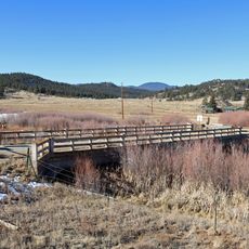
A paved bike path stretches about 8 miles from the day-use area toward Woodland Park, passing by several campgrounds along the route. This flat trail allows visitors to explore the forest without returning to their vehicles.

The community of curious travelers

AroundUs brings together thousands of curated places, local tips, and hidden gems, enriched daily by 60,000 contributors worldwide.

Start exploring
Location
GPS coordinates
39.09702,-105.09559
Latest update
December 14, 2025 18:02
Around this place
United States Air Force Academy Cadet Chapel
United States of America

United States Air Force Academy Cadet Chapel

20.3 km
Falcon Stadium
United States of America

Falcon Stadium

24.6 km
Mueller State Park
United States of America

Mueller State Park

25.3 km
Devil's Head Lookout
United States of America

Devil's Head Lookout

18.2 km
Flying W Ranch
United States of America

Flying W Ranch

27.1 km
Rampart Reservoir
United States of America

Rampart Reservoir

16.9 km
United States Air Force Academy Cemetery
United States of America

United States Air Force Academy Cemetery

22.7 km
Devils Head
United States of America

Devils Head

18.2 km
United States Air Force Academy, Cadet Area
United States of America

United States Air Force Academy, Cadet Area

20.3 km
Rocky Mountain Dinosaur Resource Center
United States of America

Rocky Mountain Dinosaur Resource Center

12.1 km
Ute Pass
United States of America

Ute Pass

18.1 km
Santa's Workshop
United States of America

Santa's Workshop

23.7 km
North Pole Colorado
United States of America

North Pole Colorado

23.9 km
Colorado Renaissance Festival
United States of America

Colorado Renaissance Festival

22.3 km
Blodgett Peak
United States of America

Blodgett Peak

22.4 km
Tri-Lakes, Colorado
United States of America

Tri-Lakes, Colorado

19.5 km
Western Museum of Mining & Industry
United States of America

Western Museum of Mining & Industry

24.3 km
Dawson Butte
United States of America

Dawson Butte

26.4 km
Eastholme
United States of America

Eastholme

24.8 km
Hornbek House
United States of America

Hornbek House

25 km
Colorado Consistory No. 1
United States of America

Colorado Consistory No. 1

24.7 km
Reginald Sinclaire House
United States of America

Reginald Sinclaire House

24.2 km
Inez Johnson Lewis School
United States of America

Inez Johnson Lewis School

19.5 km
South Platte River Bridge
United States of America

South Platte River Bridge

26.2 km
John Kinner House
United States of America

John Kinner House

22.8 km
Colorado Wolf and Wildlife Center
United States of America

Colorado Wolf and Wildlife Center

21 km
The Country Club at Woodmoor
United States of America

The Country Club at Woodmoor

22.4 km
Florissant Fossil Beds Visitors Center
United States of America

Florissant Fossil Beds Visitors Center

26.2 km
Show the full map
Reviews
Share your experience

No review yet

Discussions
Start a discussion...

No discussion yet

« Manitou Park Recreation Area, Colorado - Recreational park in Pike National Forest, Colorado » is provided by Around Us (aroundus.com). Images and texts are derived from Wikimedia project under a Creative Commons license. You are allowed to copy, distribute, and modify copies of this page, under the conditions set by the license, as long as this note is clearly visible.

Discover hidden gems everywhere you go!

From secret cafés to breathtaking viewpoints, skip the crowded tourist spots and find places that match your style. Our app makes it easy with voice search, smart filtering, route optimization, and insider tips from travelers worldwide. Download now for the complete mobile experience.

Around Us App Screenshot

A unique approach to discovering new places

Le Figaro

All the places worth exploring

France Info

A tailor-made excursion in just a few clicks

20 Minutes

Around Us
Travel Guide & Maps
Download

Send to your phone

QR Code
1

Open the camera app on your mobile.

2

Point at the QR code with your camera. A notification will appear.

3

Tap the notification to open the link.