Enable Location

We need your location to show you interesting places around you

Discover nearby places

Find interesting locations and hidden gems around you

Precise directions

Get accurate directions and distances to places

Your location is never shared with other users. It's only used when you tap the location button.

Rampart Reservoir

Log in to your account

Start exploring — it's free

Trusted by 62,198 travelers worldwide

Continue with Google
Continue with Apple
or

We will send you a code to connect

By continuing, you accept our Terms and Conditions and our Privacy Policy

Check your inbox

We've sent a pincode in your inbox. Please enter the code below.

Rampart Reservoir

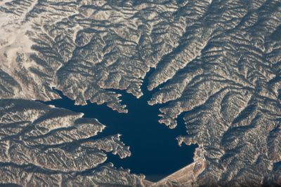
Rampart Reservoir, body of water
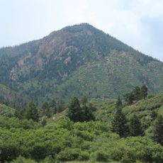
Rampart Reservoir is a large water body in Pike National Forest sitting on a high granite plateau at about 9,000 feet elevation, with clear water surrounded by pine trees and rocky terrain. The site spans roughly 500 acres and is ringed by trails, boat launch facilities, two campgrounds with tent and parking areas, and designated picnic spots along the shoreline.

The reservoir was built in the late 1960s when a dam was constructed across West Monument Creek to supply drinking water to Colorado Springs and nearby communities. Following a significant wildfire that temporarily closed the site, it reopened after cleanup and restoration work was completed.

The road to the reservoir is unpaved and rough, so drive slowly and carefully with a 20 mph speed limit throughout. All boaters must wear Coast Guard-approved life jackets, swimming is prohibited, and boat launch inspections occur at specific times to prevent the spread of invasive species.

The reservoir was built to supply drinking water to Colorado Springs and continues serving this function today, though most visitors focus on recreation and fishing activities. This working water supply means strict rules like no swimming and mandatory boat inspections exist to protect water quality, setting it apart from typical leisure lakes.

The community of curious travelers

AroundUs brings together thousands of curated places, local tips, and hidden gems, enriched daily by 60,000 contributors worldwide.

Start exploring
Location
GPS coordinates
38.98077,-104.97000
Latest update
February 7, 2026 11:01
Around this place
Garden of the Gods
United States of America

Garden of the Gods

14.3 km
Manitou Incline
United States of America

Manitou Incline

14.2 km
United States Air Force Academy Cadet Chapel
United States of America

United States Air Force Academy Cadet Chapel

7.5 km
Manitou Cliff Dwellings
United States of America

Manitou Cliff Dwellings

14 km
Falcon Stadium
United States of America

Falcon Stadium

11.2 km
Cave of the Winds
United States of America

Cave of the Winds

12.7 km
Glen Eyrie
United States of America

Glen Eyrie

12.4 km
Miramont Castle
United States of America

Miramont Castle

14.2 km
Flying W Ranch
United States of America

Flying W Ranch

10.4 km
Manitou Cliff Dwellings
United States of America

Manitou Cliff Dwellings

14 km
Manitou Mineral Springs
United States of America

Manitou Mineral Springs

14.3 km
United States Air Force Academy Cemetery
United States of America

United States Air Force Academy Cemetery

10.6 km
United States Air Force Academy, Cadet Area
United States of America

United States Air Force Academy, Cadet Area

7.5 km
Rainbow Falls
United States of America

Rainbow Falls

12.9 km
The Broadmoor Manitou and Pikes Peak Cog Railway
United States of America

The Broadmoor Manitou and Pikes Peak Cog Railway

14.3 km
Rocky Mountain Dinosaur Resource Center
United States of America

Rocky Mountain Dinosaur Resource Center

7.2 km
Manitou Springs Historic District
United States of America

Manitou Springs Historic District

14.3 km
Santa's Workshop
United States of America

Santa's Workshop

8.5 km
North Pole Colorado
United States of America

North Pole Colorado

8.6 km
Blodgett Peak
United States of America

Blodgett Peak

6 km
Cliff House
United States of America

Cliff House

14.2 km
Balanced Rock
United States of America

Balanced Rock

14.4 km
Western Museum of Mining & Industry
United States of America

Western Museum of Mining & Industry

13.3 km
Steamboat Rock
United States of America

Steamboat Rock

14.4 km
Barker House (Manitou Springs, Colorado)
United States of America

Barker House (Manitou Springs, Colorado)

14.4 km
Manitou Bathhouse
United States of America

Manitou Bathhouse

14.2 km
Eastholme
United States of America

Eastholme

9.3 km
Bridge over Fountain Creek
United States of America

Bridge over Fountain Creek

12.9 km
Show the full map
« Rampart Reservoir - body of water » is provided by Around Us (aroundus.com). Images and texts are derived from Wikimedia project under a Creative Commons license. You are allowed to copy, distribute, and modify copies of this page, under the conditions set by the license, as long as this note is clearly visible.

Discover hidden gems everywhere you go!

From secret cafés to breathtaking viewpoints, skip the crowded tourist spots and find places that match your style. Our app makes it easy with voice search, smart filtering, route optimization, and insider tips from travelers worldwide. Download now for the complete mobile experience.

Around Us App Screenshot

A unique approach to discovering new places

Le Figaro

All the places worth exploring

France Info

A tailor-made excursion in just a few clicks

20 Minutes

Around Us
Travel Guide & Maps
Download

Send to your phone

QR Code
1

Open the camera app on your mobile.

2

Point at the QR code with your camera. A notification will appear.

3

Tap the notification to open the link.