Enable Location

We need your location to show you interesting places around you

Discover nearby places

Find interesting locations and hidden gems around you

Precise directions

Get accurate directions and distances to places

Your location is never shared with other users. It's only used when you tap the location button.

Blodgett Peak

Log in to your account

Start exploring — it's free

Trusted by 65,418 travelers worldwide

Continue with Google
Continue with Apple
or

We will send you a code to connect

By continuing, you accept our Terms and Conditions and our Privacy Policy

Check your inbox

We've sent a pincode in your inbox. Please enter the code below.

Blodgett Peak
Discussion Reviews 1 Photos
3.5k Popularity

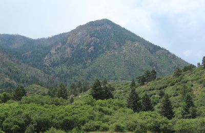
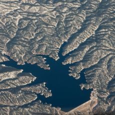
Blodgett Peak, Mountain summit in Pike National Forest, Colorado.

Blodgett Peak is a mountain summit located just north of Colorado Springs in Colorado, rising to around 9,430 feet (about 2,875 meters). The area around it is managed as an open space with hiking trails that pass through canyons, pine forests, and rocky terrain at various elevations.

In 1959, the U.S. military studied the mountain as a possible site for an underground command center, but chose Cheyenne Mountain nearby instead. A major fire in 2012 burned through much of the surrounding forest, prompting years of restoration work on the slopes.

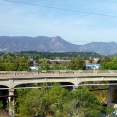
Blodgett Peak is clearly visible from Colorado Springs and serves as a familiar landmark for people living in the city below. Many locals hike here regularly, treating the trails as part of their outdoor routine rather than a special excursion.

The hike is strenuous and best suited for those who are comfortable on uneven, rocky ground and carry enough water for a long outing. Starting early in the day is a good habit here, as afternoon weather can shift quickly at this elevation.

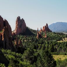
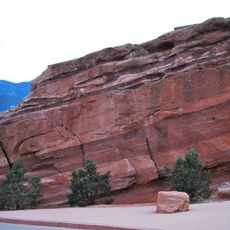
The rock faces near the summit contain three distinct geological layers, including Pierre Shale and Manitou Limestone, each formed during a different ocean period hundreds of millions of years ago. Visitors who look closely at the exposed rock walls can often spot the color shifts between these layers without any special equipment.

The community of curious travelers

AroundUs brings together thousands of curated places, local tips, and hidden gems, enriched daily by 60,000 contributors worldwide.

Start exploring
Location
GPS coordinates
38.95886,-104.90717
Latest update
March 3, 2026 13:58
Around this place
Garden of the Gods
United States of America

Garden of the Gods

9.6 km
Focus on the Family
United States of America

Focus on the Family

10.2 km
United States Air Force Academy Cadet Chapel
United States of America

United States Air Force Academy Cadet Chapel

5.7 km
Manitou Cliff Dwellings
United States of America

Manitou Cliff Dwellings

10.6 km
Falcon Stadium
United States of America

Falcon Stadium

7 km
Cave of the Winds
United States of America

Cave of the Winds

9.6 km
Glen Eyrie
United States of America

Glen Eyrie

7.7 km
Miramont Castle
United States of America

Miramont Castle

11.2 km
Flying W Ranch
United States of America

Flying W Ranch

4.7 km
Manitou Cliff Dwellings
United States of America

Manitou Cliff Dwellings

10.7 km
Manitou Mineral Springs
United States of America

Manitou Mineral Springs

11.3 km
Rampart Reservoir
United States of America

Rampart Reservoir

6 km
United States Air Force Academy Cemetery
United States of America

United States Air Force Academy Cemetery

7.6 km
United States Air Force Academy, Cadet Area
United States of America

United States Air Force Academy, Cadet Area

5.7 km
Rainbow Falls
United States of America

Rainbow Falls

10 km
Manitou Springs Historic District
United States of America

Manitou Springs Historic District

11.3 km
Santa's Workshop
United States of America

Santa's Workshop

8.5 km
Rock Ledge Ranch Historic Site
United States of America

Rock Ledge Ranch Historic Site

10 km
Balanced Rock
United States of America

Balanced Rock

10.5 km
Western Museum of Mining & Industry
United States of America

Western Museum of Mining & Industry

10.2 km
Steamboat Rock
United States of America

Steamboat Rock

10.5 km
Manitou Bathhouse
United States of America

Manitou Bathhouse

11.1 km
Eastholme
United States of America

Eastholme

8.7 km
Bridge over Fountain Creek
United States of America

Bridge over Fountain Creek

11.3 km
Bridge over Fountain Creek
United States of America

Bridge over Fountain Creek

10 km
Cottonwood Creek Bridge
United States of America

Cottonwood Creek Bridge

9.1 km
Regal Interquest Stadium 14
United States of America

Regal Interquest Stadium 14

9.3 km
Ppld - Library 21c
United States of America

Ppld - Library 21c

10 km
Show the full map
Reviews
Share your experience

No review yet

Discussions
Start a discussion...

No discussion yet

« Blodgett Peak - Mountain summit in Pike National Forest, Colorado » is provided by Around Us (aroundus.com). Images and texts are derived from Wikimedia project under a Creative Commons license. You are allowed to copy, distribute, and modify copies of this page, under the conditions set by the license, as long as this note is clearly visible.

Discover hidden gems everywhere you go!

From secret cafés to breathtaking viewpoints, skip the crowded tourist spots and find places that match your style. Our app makes it easy with voice search, smart filtering, route optimization, and insider tips from travelers worldwide. Download now for the complete mobile experience.

Around Us App Screenshot

A unique approach to discovering new places

Le Figaro

All the places worth exploring

France Info

A tailor-made excursion in just a few clicks

20 Minutes

Around Us
Travel Guide & Maps
Download

Send to your phone

QR Code
1

Open the camera app on your mobile.

2

Point at the QR code with your camera. A notification will appear.

3

Tap the notification to open the link.