Chest opened
+${chestReward.xp} XP
Explorer
NOUVEAU ×${chestReward.collectible.quantity}
tapez pour fermer
Chest locked

Open chests in the app

Around Us is built for your phone — chests unlock when you walk, explore and capture nearby places.

Enable Location

We need your location to show you interesting places around you

Discover nearby places

Find interesting locations and hidden gems around you

Precise directions

Get accurate directions and distances to places

Your location is never shared with other users. It's only used when you tap the location button.

Log in to your account

Start exploring — it's free

Trusted by 72,972 travelers worldwide

Continue with Google
Continue with Apple
or

We will send you a code to connect

By continuing, you accept our Terms and Conditions and our Privacy Policy

Check your inbox

We've sent a pincode in your inbox. Please enter the code below.

Newfoundland Evaporation Basin
Discussion Reviews Photo
2k Popularity

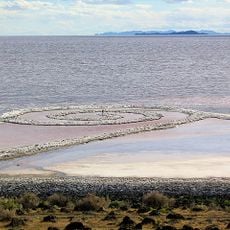
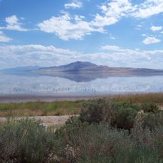
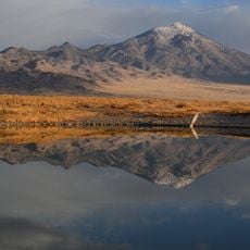
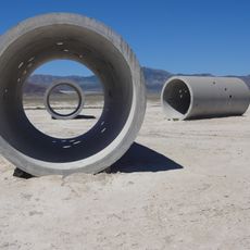
Newfoundland Evaporation Basin, Salt flat evaporation basin in Box Elder County, Utah.

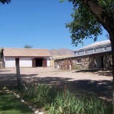
Newfoundland Evaporation Basin is a salt flat system in Box Elder County, northwestern Utah, designed to collect water and allow minerals to accumulate through evaporation. The site features multiple large ponds connected by channels that spread across the flat desert landscape.

The basin was created by Utah in 1986 to divert excess water from the Great Salt Lake and regulate the lake's water level. It became a key water management infrastructure for the region since its establishment.

The basin represents industrial ingenuity in water management, demonstrating how communities adapt to environmental challenges in the American West.

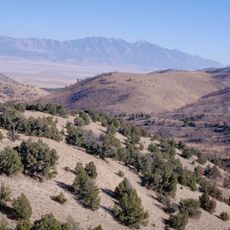
The location is highly remote and requires careful planning since cellular coverage is absent and roads are not well marked. Visitors should allow plenty of time and research their route before arriving.

The system uses a natural gas pipeline running roughly 60 kilometers and more than 40 kilometers of dikes to control water flow. These engineering structures are particularly visible from above and reveal the project's scale.

The community of curious travelers

AroundUs brings together thousands of curated places, local tips, and hidden gems, enriched daily by 60,000 contributors worldwide.

Start exploring
Location
GPS coordinates
41.08326,-113.58417
Latest update
December 14, 2025 09:40
Around this place
Spiral Jetty
United States of America

Spiral Jetty

86.2 km
Bonneville Speedway
United States of America

Bonneville Speedway

44.3 km
Metaphor: The Tree of Utah
United States of America

Metaphor: The Tree of Utah

39 km
City of Rocks National Reserve
United States of America

City of Rocks National Reserve

110.9 km
Golden Spike National Historical Park
United States of America

Golden Spike National Historical Park

105 km
Antelope Island bison herd
United States of America

Antelope Island bison herd

116.5 km
United States of America

Japanese Village

103 km
Antelope Island State Park
United States of America

Antelope Island State Park

116.5 km
Pilot Peak
United States of America

Pilot Peak

42 km
Danger Cave
United States of America

Danger Cave

51.8 km
Fielding Garr Ranch
United States of America

Fielding Garr Ranch

116.5 km
Deseret Peak
United States of America

Deseret Peak

106.5 km
Castle Rocks State Park
United States of America

Castle Rocks State Park

117.6 km
Hogup Cave
United States of America

Hogup Cave

59.2 km
Cedar Mountain Wilderness
United States of America

Cedar Mountain Wilderness

76.5 km
Deseret Peak Wilderness
United States of America

Deseret Peak Wilderness

99.3 km
Sun Tunnels
United States of America

Sun Tunnels

33.9 km
Lincoln Highway Bridge
United States of America

Lincoln Highway Bridge

114.7 km
Thomas N. Taylor House
United States of America

Thomas N. Taylor House

109.3 km
A. N. Tanner House
United States of America

A. N. Tanner House

73.6 km
Hilda Erickson House
United States of America

Hilda Erickson House

108.1 km
Alex and Mary Alice Johnson House
United States of America

Alex and Mary Alice Johnson House

108.7 km
James and Penninah Wrathall House
United States of America

James and Penninah Wrathall House

108.2 km
Maverick Canyon
United States of America

Maverick Canyon

85.7 km
Grantsville First Ward Meetinghouse
United States of America

Grantsville First Ward Meetinghouse

107.8 km
Grantsville School and Meetinghouse
United States of America

Grantsville School and Meetinghouse

107.8 km
John T. Rich House
United States of America

John T. Rich House

107.9 km
Johnson Hall-Deseret Mercantile Building
United States of America

Johnson Hall-Deseret Mercantile Building

108.6 km
Show the full map
Reviews
Share your experience

No review yet

Discussions
Start a discussion...

No discussion yet

« Newfoundland Evaporation Basin - Salt flat evaporation basin in Box Elder County, Utah » is provided by Around Us (aroundus.com). Images and texts are derived from Wikimedia project under a Creative Commons license. You are allowed to copy, distribute, and modify copies of this page, under the conditions set by the license, as long as this note is clearly visible.

Discover hidden gems everywhere you go!

From secret cafés to breathtaking viewpoints, skip the crowded tourist spots and find places that match your style. Our app makes it easy with voice search, smart filtering, route optimization, and insider tips from travelers worldwide. Download now for the complete mobile experience.

Around Us App Screenshot

A unique approach to discovering new places

Le Figaro

All the places worth exploring

France Info

A tailor-made excursion in just a few clicks

20 Minutes

Around Us
Travel Guide & Maps
Download

Send to your phone

QR Code
1

Open the camera app on your mobile.

2

Point at the QR code with your camera. A notification will appear.

3

Tap the notification to open the link.